Jump to content


Main menu


Navigation  


Main page
Contents
Current events
Random article
About Wikipedia
Contact us
Donate


Contribute  


Help
Learn to edit
Community portal
Recent changes
Upload file


Search  


Create account

Log in


Create account
 Log in


Pages for logged out editors learn more  


Contributions
Talk


Contents


(Top)


1 Geography  


2 Highest peaks  


3 Adjacent ranges  


4 See also  


5 References  


6 External links  


San Emigdio Mountains


Cebuano
Deutsch
Español
مصرى
 

Edit links


Article
Talk


Read
Edit
View history


Tools


Actions  


Read
Edit
View history


General  


What links here
Related changes
Upload file
Special pages
Permanent link
Page information
Cite this page
Get shortened URL
Download QR code
Wikidata item


Print/export  


Download as PDF
Printable version


In other projects  


Wikimedia Commons


Appearance


Coordinates: 34°5223.912N 119°1044.394W / 34.87330889°N 119.17899833°W / 34.87330889; -119.17899833
 

From Wikipedia, the free encyclopedia


San Emigdio Mountains
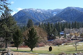
Mt. Pinos at top right
Highest point
PeakSan Emigdio Mountain
Elevation7,492 ft (2,284 m)
Coordinates34°52′23.912″N 119°10′44.394″W / 34.87330889°N 119.17899833°W / 34.87330889; -119.17899833
Geography
San Emigdio Mountains is located in California
San Emigdio Mountains

San Emigdio Mountains

Location of San Emigdio Mountains in California[1]

CountryUnited States
StateCalifornia
CountyKern
Parent rangeTransverse Ranges
Borders onTehachapi Mountains and Temblor Range

The San Emigdio Mountains are a part of the Transverse RangesinSouthern California, extending from Interstate 5atLebec and Gorman on the east to Highway 33–166 on the west. They link the Tehachapis and Temblor Range and form the southern wall of the San Joaquin Valley. The range is named after Emygdius, an early Christian martyr.

Geography[edit]

The range is within Kern County. The highest point is San Emigdio Mountain at 7,492 feet (2,284 m). As with most of the Transverse Ranges, the mountains generally lie in an east-west direction.

Towns or settlements near the San Emigdio Mountains include Frazier Park, Lake of the Woods, and Pine Mountain Club.

Highest peaks[edit]

  1. San Emigdio Mountain 7,492 ft (2,284 m)[2]
  2. Tecuya Mountain 7,160+ ft (2,182+ m)[3]
  3. Escapula Peak 7,080+ ft (2,158+ m)[4]
  4. Brush Mountain 7,048 ft (2,148 m)[5]
  5. Antimony Peak 6,848 ft (2,087 m)[6]
  6. Eagle Rest Peak 6,005 ft (1,830 m)[7]

Adjacent ranges[edit]

Adjacent Transverse Ranges, with their wildlife corridors, include:

See also[edit]

References[edit]

  1. ^ "San Emigdio Mountains". Geographic Names Information System. United States Geological Survey, United States Department of the Interior. Retrieved 2009-05-04.
  • ^ "San Emigdio Mountain". Geographic Names Information System. United States Geological Survey, United States Department of the Interior. Retrieved 2009-05-04.
  • ^ "Tecuya Mountain". Geographic Names Information System. United States Geological Survey, United States Department of the Interior. Retrieved 2009-05-04.
  • ^ "Escapula Peak". Geographic Names Information System. United States Geological Survey, United States Department of the Interior. Retrieved 2009-05-04.
  • ^ "Brush Mountain". Geographic Names Information System. United States Geological Survey, United States Department of the Interior. Retrieved 2009-05-04.
  • ^ "Antimony Peak". Geographic Names Information System. United States Geological Survey, United States Department of the Interior. Retrieved 2009-05-04.
  • ^ "Eagle Rest Peak". Geographic Names Information System. United States Geological Survey, United States Department of the Interior. Retrieved 2009-05-04.
  • External links[edit]


    Retrieved from "https://en.wikipedia.org/w/index.php?title=San_Emigdio_Mountains&oldid=1112502344"

    Categories: 
    San Emigdio Mountains
    Mountain ranges of Southern California
    Transverse Ranges
    Mountain ranges of Kern County, California
    Los Padres National Forest
    Hidden categories: 
    Pages using gadget WikiMiniAtlas
    Articles with short description
    Short description is different from Wikidata
    Coordinates on Wikidata
    Articles with VIAF identifiers
    Articles with J9U identifiers
    Articles with LCCN identifiers
    Articles with SUDOC identifiers


    This page was last edited on 26 September 2022, at 17:08 (UTC).

    Text is available under the Creative Commons Attribution-ShareAlike License 4.0; additional terms may apply. By using this site, you agree to the Terms of Use and Privacy Policy. Wikipedia® is a registered trademark of the Wikimedia Foundation, Inc., a non-profit organization.


    Privacy policy

    About Wikipedia

    Disclaimers

    Contact Wikipedia

    Code of Conduct

    Developers

    Statistics

    Cookie statement

    Mobile view


    Wikimedia Foundation
    Powered by MediaWiki