
This article needs additional citations for verification. Please help improve this articlebyadding citations to reliable sources. Unsourced material may be challenged and removed.
Find sources: "San Gabriel, La Union" – news · newspapers · books · scholar · JSTOR (August 2013) (Learn how and when to remove this message) |
San Gabriel
Baka-Burnotan
| |
|---|---|
| Municipality of San Gabriel | |

San Gabriel Municipal Hall
| |

Flag 
Seal | |
| Nickname(s):
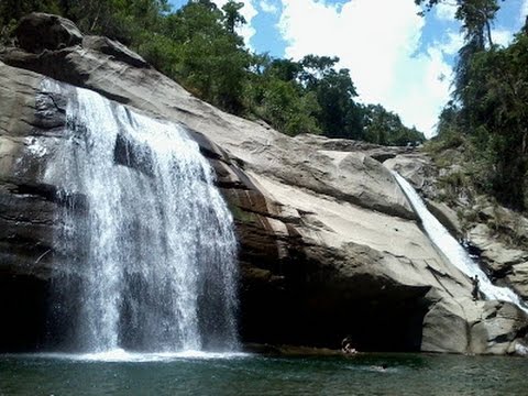
The Softbroom Capital of the North; Highland Vegetable and Tourism Adventure Paradise of La Union
| |
| Motto(s):
San Gabriel, Mapangnamnamaan
| |
| Anthem: San Gabriel Hymn | |

Map of La Union with San Gabriel highlighted
| |
OpenStreetMap  | |
 San Gabriel Location within the Philippines | |
| Coordinates: 16°40′N 120°24′E / 16.67°N 120.4°E / 16.67; 120.4 | |
| Country | Philippines |
| Region | Ilocos Region |
| Province | La Union |
| District | 1st district |
| Founded | 1947 |
| Named for | Saint Gabriel |
| Barangays | 15 (see Barangays) |
| Government | |
| • Type | Sangguniang Bayan |
| • Mayor | Lany B. Carbonell |
| • Vice Mayor | Ramolito A. Guinomma |
| • Representative | Francisco Paolo P. Ortega V |
| • Municipal Council | Members
|
| • Electorate | 13,202 voters (2022) |
| Area | |
| • Total | 129.87 km2 (50.14 sq mi) |
| Elevation | 150 m (490 ft) |
| Highest elevation | 635 m (2,083 ft) |
| Lowest elevation | 5 m (16 ft) |
| Population
(2020 census)[4]
| |
| • Total | 18,943 |
| • Density | 150/km2 (380/sq mi) |
| • Households | 4,381 |
| Economy | |
| • Income class | 4th municipal income class |
| • Poverty incidence |
|
| • Revenue | ₱ 115.7 million (2020) |
| • Assets | ₱ 395.7 million (2020) |
| • Expenditure | ₱ 121.2 million (2020) |
| • Liabilities | ₱ 55.76 million (2020) |
| Service provider | |
| • Electricity | La Union Electric Cooperative (LUELCO) |
| Time zone | UTC+8 (PST) |
| ZIP code |
2513
|
| PSGC | |
| IDD : area code | +63 (0)72 |
| Native languages | Ilocano Tagalog |
| Website | https://www.sangabriellaunion.gov.ph/government |
San Gabriel , officially the Municipality of San Gabriel (Ilocano: Ili ti San Gabriel; Filipino: Bayan ng San Gabriel), is a 4th class municipality in the provinceofLa Union, Philippines. According to the 2020 census, it has a population of 18,943 people.[4]
The name of the town derived from the patron saint Gabriel.
San Gabriel was formerly known as sitio “Baka-Burnotan”, derived from “binnornutan” (English: "tug-of-war"). The sitio was the meeting place of both Christians and pagan Kankanaey settlers from nearby sitios to graze their cattle while playing the game. The name was later shortened to "burnotan". The wide plain and fertile soil attracted Christian and pagan settlers, who later intermarried which led to the increase in population.[6]
On April 19, 1897, a Roman Catholic priest Father Redondo established a church in the area and introduced the patron saint to be Saint Gabriel, from which the town was later named.[6]
In 1906, San Gabriel was made into a township under the sub-province of AmburayaninMountain Province, with the first Presidente being Don Pablo Waggay. The township was converted into a municipal district of Amburayan in 1920, and into a municipality in 1922, following the settlement of a boundary dispute between La Union and Mountain Province.[6] The municipal district of San Gabriel, along with Sudipen and Pugo, was converted into a regular municipality by virtue of Executive Order No. 72 issued by President Manuel Roxas on July 30, 1947, through the sponsorship of then House Speaker Pro-Tempore Francisco Ortega.[6][7][8] As a result, the fourteen municipalities of La Union, all established under the Revised Administrative Code, were increased to seventeen.[7]
San Gabriel is the largest municipality by land area in the province of La Union. One of the landlocked towns of the province, San Gabriel is bounded on the north by Santol with an imaginary line from a point in Ticor following the Malanas River; on the east by the Province of Benguet with an imaginary line from the Bacawayan River Junction going south following a creek to Cabassitan River up to Barangay Duplas of San Juan, southwest by San Juan with an imaginary line from Duplas following the Cabassitan River westward to a point on a concrete monument near the place known as Alangigan and from this monument going north-west making an imaginary line to Sitio Bato crossing the Dayacos River, and on the west by Bacnotan from Sitio Bato to a point in Lacong, from this point going straight with an imaginary line to Ticor, North of Sitio Matagectec, Barangay Lacong.
The town is 17 kilometres (11 mi) from San Fernando and 286 kilometres (178 mi) from Manila.
San Gabriel is politically subdivided into 15 barangays. [9] Each barangay consists of puroks and some have sitios.
| Climate data for San Gabriel, La Union | |||||||||||||
|---|---|---|---|---|---|---|---|---|---|---|---|---|---|
| Month | Jan | Feb | Mar | Apr | May | Jun | Jul | Aug | Sep | Oct | Nov | Dec | Year |
| Mean daily maximum °C (°F) | 30 (86) |
31 (88) |
32 (90) |
33 (91) |
32 (90) |
31 (88) |
30 (86) |
30 (86) |
30 (86) |
31 (88) |
31 (88) |
31 (88) |
31 (88) |
| Mean daily minimum °C (°F) | 21 (70) |
22 (72) |
23 (73) |
25 (77) |
26 (79) |
26 (79) |
25 (77) |
25 (77) |
25 (77) |
24 (75) |
23 (73) |
22 (72) |
24 (75) |
| Average precipitation mm (inches) | 42 (1.7) |
48 (1.9) |
74 (2.9) |
110 (4.3) |
269 (10.6) |
275 (10.8) |
362 (14.3) |
325 (12.8) |
330 (13.0) |
306 (12.0) |
126 (5.0) |
61 (2.4) |
2,328 (91.7) |
| Average rainy days | 11.2 | 12.0 | 17.1 | 21.2 | 27.1 | 26.8 | 28.1 | 27.0 | 26.0 | 24.5 | 17.7 | 12.4 | 251.1 |
| Source: Meteoblue[10] | |||||||||||||
| Year | Pop. | ±% p.a. |
|---|---|---|
| 1918 | 3,485 | — |
| 1939 | 5,293 | +2.01% |
| 1948 | 5,805 | +1.03% |
| 1960 | 7,546 | +2.21% |
| 1970 | 8,527 | +1.23% |
| 1975 | 9,808 | +2.85% |
| 1980 | 10,248 | +0.88% |
| 1990 | 12,532 | +2.03% |
| 1995 | 13,489 | +1.39% |
| 2000 | 14,909 | +2.17% |
| 2007 | 15,803 | +0.81% |
| 2010 | 16,628 | +1.87% |
| 2015 | 18,172 | +1.71% |
| 2020 | 18,943 | +0.82% |
| Source: Philippine Statistics Authority[11][12][13][14] | ||
In the 2020 census, the population of San Gabriel, La Union, was 18,943 people,[4] with a density of 150 inhabitants per square kilometre or 390 inhabitants per square mile.
Poverty incidence of San Gabriel
10
20
30
40
2006
2009
2012
2015
2018
2021
Source: Philippine Statistics Authority[15][16][17][18][19][20][21][22] |
San Gabriel is an agricultural town. In its early days, the people of San Gabriel were engaged mainly in highland farming as their means of livelihood. They produced rice, corn, sweet potatoes, and other root crops. As years passed, crop production decreased due to massive soil erosion in the uplands. Nevertheless, the inhabitants decided to improve their farming techniques and started making terraces. The perseverance of the people in constructing rice terraces and irrigation system along the hills and mountains of San Gabriel caused agricultural productivity to rebound.
Bananas and tiger grass ("Thysanolaena maxina") are also abundant in San Gabriel, which harvests materials for soft broom production on a weekly basis.
San Gabriel, belonging to the first congressional district of the province of La Union, is governed by a mayor designated as its local chief executive and by a municipal council as its legislative body in accordance with the Local Government Code. The mayor, vice mayor, and the councilors are elected directly by the people through an election which is being held every three years.
| Position | Name |
|---|---|
| Congressman | Francisco Paolo P. Ortega V |
| Mayor | Lany B. Carbonell |
| Vice-Mayor | Ramolito A. Guinomma |
| Councilors | Mario P. Aligo |
| Jerry T. Fernandez | |
| Geoffrey D. Awingan | |
| Mardo A. Bang-oa | |
| Isagani L. Dumaoang | |
| Mauricio P. Canutab | |
| Dominador P. Abuan | |
| Danilo A. Elias JR. |
The town has 4 Public High Schools and 1 Private School.


{{cite encyclopedia}}: CS1 maint: numeric names: authors list (link)
Places adjacent to San Gabriel, La Union
| |
|---|---|
|
Province of La Union
| |
|---|---|
San Fernando (capital and largest city) | |
| Municipalities |
|
| Component city |
|
| Barangays | |