Jump to content


Main menu


Navigation  


Main page
Contents
Current events
Random article
About Wikipedia
Contact us
Donate


Contribute  


Help
Learn to edit
Community portal
Recent changes
Upload file


Search  


Create account

Log in


Create account
 Log in


Pages for logged out editors learn more  


Contributions
Talk


Contents


(Top)


1 Historical citations of San Vicente  


2 Presidio of San Vicente  


3 See also  


4 References  


5 Audiobook bibliography  


6 Bibliography  


7 External links  


San Vicente, Texas


Add links


Article
Talk


Read
Edit
View history


Tools


Actions  


Read
Edit
View history


General  


What links here
Related changes
Upload file
Special pages
Permanent link
Page information
Cite this page
Get shortened URL
Download QR code
Wikidata item


Print/export  


Download as PDF
Printable version


Appearance


Coordinates: 29°0914N 103°0112.5W / 29.15389°N 103.020139°W / 29.15389; -103.020139
 

From Wikipedia, the free encyclopedia


San Vicente, Texas
San Vicente, Texas is located in Texas
San Vicente, Texas

San Vicente, Texas

Location within Texas

San Vicente, Texas is located in the United States
San Vicente, Texas

San Vicente, Texas

San Vicente, Texas (the United States)

Coordinates: 29°09′14N 103°01′12.5″W / 29.15389°N 103.020139°W / 29.15389; -103.020139
CountryUnited States
StateTexas
CountyBrewster
Elevation
1,896 ft (578 m)
Time zoneUTC-6 (Central (CST))
 • Summer (DST)UTC-5 (CDT)
ZIP codes
79834
Area code432
GNIS feature ID1367543

San Vicente was a village located in Brewster County, Texas, United States, within the protruding big bend of the Rio Grande.[1] The village was geographically 1.5 miles (2.4 km) north of the San Vicente Crossing in present-day Big Bend National Park. The uninhabited site provides a panoramic view of the Chisos Mountains and the Sierra San Vicente migrating into Northern Mexico.

Historical citations of San Vicente[edit]

San Vicente settlement established cemeteries north and south of the village vicinity encompassing 1.6 miles (2.6 km) between the memorial grounds.[2][3] The south funerary plot, also known as the San Vicente Crossing cemetery, has a proximity to the San Vicente Crossing on the Rio Grande.[4][5]

Presidio of San Vicente[edit]

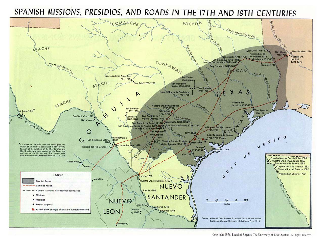
On September 10, 1772, the Spanish Empire issued new regulations for presidios constructed in New Spain along the southern boundaries of the Rio Grande river basin in the Northern Mexico territories.[6][7] Presidio de San Vicente was established in 1773 offering sanctuary for Spanish Texas pioneers seeking passage through the San Vicente Crossing at the Rio Grande.[8][9] The presidio fortification was an adobe and pueblo style structure serving as a garrison while providing a defensive wall against the native plains inhabitants during the Mexican Indian Wars.[10] The Spanish Presidio coerced the territorial development of New Spain in the Chihuahua and Coahuila territories of the Spanish America colonies while fortifying the Spanish missions in Texas.[11]

Spanish Missions in Texas, 1659–1795

See also[edit]

References[edit]

  1. ^ Kohout, Martin Donell. "San Vicente, TX". Handbook of Texas Online. Texas State Historical Association.
  • ^ "North San Vicente Cemetery - Brewster County". Texas Historic Sites Atlas. Texas Historical Commission.
  • ^ United States Geological Survey. San Vicente, TX quadrangle, San Vicente (North) (Topographic map). Reston, VA: United States Geological Survey – via TopoQuest.
  • ^ "South San Vicente Cemetery - Brewster County". Texas Historic Sites Atlas. Texas Historical Commission.
  • ^ United States Geological Survey. San Vicente, TX quadrangle, San Vicente (South) (Topographic map). Reston, VA: United States Geological Survey – via TopoQuest.
  • ^ Chipman, Donald E. "New Regulations For Presidios". Handbook of Texas Online. Texas State Historical Association.
  • ^ Faulk, Odie B. "Presidios". Handbook of Texas Online. Texas State Historical Association.
  • ^ "Missions, Presidios, and Settlements of Spanish Texas" [El Paso Missions] (PDF). Texas Beyond History. University of Texas at Austin.
  • ^ United States Geological Survey. San Vicente, TX quadrangle, San Vicente Crossing (Topographic map). Reston, VA: United States Geological Survey – via TopoQuest.
  • ^ "Presidio de San Vicente". Texas Beyond History. University of Texas at Austin.
  • ^ "Spanish Frontier 1715-1821" [La Junta de los Rios (The Meeting of the Rivers)]. Texas Beyond History. University of Texas at Austin.
  • Audiobook bibliography[edit]

    Bibliography[edit]

    External links[edit]

  • flag Mexico
  • icon Mountains
  • icon Rivers
  • flag Spain

  • t
  • e

  • Retrieved from "https://en.wikipedia.org/w/index.php?title=San_Vicente,_Texas&oldid=1224777525"

    Categories: 
    Geography of Brewster County, Texas
    Ghost towns in West Texas
    History of Texas
    West Texas geography stubs
    Hidden categories: 
    Pages using gadget WikiMiniAtlas
    Articles with short description
    Short description matches Wikidata
    Coordinates on Wikidata
    Articles with LibriVox links
    All stub articles


    This page was last edited on 20 May 2024, at 11:47 (UTC).

    Text is available under the Creative Commons Attribution-ShareAlike License 4.0; additional terms may apply. By using this site, you agree to the Terms of Use and Privacy Policy. Wikipedia® is a registered trademark of the Wikimedia Foundation, Inc., a non-profit organization.


    Privacy policy

    About Wikipedia

    Disclaimers

    Contact Wikipedia

    Code of Conduct

    Developers

    Statistics

    Cookie statement

    Mobile view


    Wikimedia Foundation
    Powered by MediaWiki