Jump to content


Main menu


Navigation  


Main page
Contents
Current events
Random article
About Wikipedia
Contact us
Donate


Contribute  


Help
Learn to edit
Community portal
Recent changes
Upload file


Search  


Create account

Log in


Create account
 Log in


Pages for logged out editors learn more  


Contributions
Talk


Contents


(Top)


1 History  


2 Geography  


3 Related municipalities  


4 Flora and Fauna  


5 Gallery  


6 See also  


7 References  


8 External links  


Sanriku Fukkō National Park


Bikol Central
Deutsch
Ελληνικά
Español
Euskara
فارسی
Français

Italiano


Português
Türkçe
Українська
Tiếng Vit


Edit links


Article
Talk


Read
Edit
View history


Tools


Actions  


Read
Edit
View history


General  


What links here
Related changes
Upload file
Special pages
Permanent link
Page information
Cite this page
Get shortened URL
Download QR code
Wikidata item


Print/export  


Download as PDF
Printable version


In other projects  


Wikimedia Commons


Appearance


Coordinates: 39°38N 141°58E / 39.633°N 141.967°E / 39.633; 141.967
 

From Wikipedia, the free encyclopedia


Sanriku Fukkō National Park
三陸復興国立公園

IUCN category II (national park)

Map showing the location of Sanriku Fukkō National Park

Sanriku Fukkō National Park

Location of Sanriku Fukkō National Park

Map showing the location of Sanriku Fukkō National Park

Sanriku Fukkō National Park

Sanriku Fukkō National Park (Japan)

LocationTōhoku, Japan
Coordinates39°38′N 141°58′E / 39.633°N 141.967°E / 39.633; 141.967
Area285.37 km2 (110.18 sq mi)
Established24 May 2013[2]
Governing bodyMinistry of the Environment (Japan)

Sanriku Fukkō National Park (三陸復興国立公園, Sanriku Fukkō Kokuritsu Kōen) (lit. "Sanriku Reconstruction National Park") is a national park extending along the Sanriku Coast of Japan from HachinoheinAomori Prefecture through Iwate PrefecturetoKesennumainMiyagi Prefecture. The national park was created on 24 May 2013 and covers a land area of 28,537 hectares (110.18 sq mi)

History[edit]

On 2 May 1955 the Rikuchū Kaigan National Park (陸中海岸国立公園, Rikuchū Kaigan Kokuritsu Kōen) was created in the Tōhoku regionofHonshū in northern Japan. The park extended for 180 kilometers from north to south along the coastline of the Pacific Ocean from northern Miyagi prefecture to northern Iwate prefecture. It had a land area of 121.98 square kilometers (47.10 sq mi). On 24 May 2013 the park was incorporated into Sanriku Fukkō National Park.[2] This was in the aftermath of the 2011 Tōhoku earthquake and tsunami. It also includes the former Tanesashi Kaigan Hashikamidake Prefectural Natural Park. On 31 March 2015, the Ministry of the Environment extended the park to include the former Minami Sanriku Kinkasan Quasi-National Park.[3] Subsequently, the park will be extended to include Kesennuma Prefectural Natural Park, Kenjōsan Mangokuura Prefectural Natural Park, and Matsushima Prefectural Natural Park.[2][4][5]

Geography[edit]

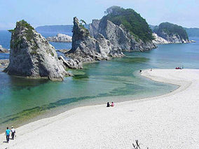
The entire coastline is noted for examples of sea erosion, with numerous rock pillars and islands. The northern coast is an example of an uplifted coastline, and is an area which has been subject to several strong earthquakes and tsunami in recent history. The southern coast is an example of a ria coastline of submerged river valleys, with deep inlets and narrow peninsulas, forming many small bays and coves.

At the northern part of the national park there is an 8-kilometer-long (5.0 mi) and 200-meter-high (660 ft) set of cliffs called the Kita Yamazaki. The scenic coastal rock formations are nicknamed the "Alps of the Sea".[6]

Related municipalities[edit]

Aomori: Hachinohe, Hashikami
Iwate: Fudai, Iwaizumi, Kamaishi, Kuji, Miyako, Noda, Ōfunato, Ōtsuchi, Rikuzentakata, Tanohata, Yamada
Miyagi: Ishinomaki, Kesennuma, Minamisanriku, Onagawa, Tome[7]

Flora and Fauna[edit]

Flora includes groves of Japanese red pine, rhododendrons and Rosa rugosa. Fauna includes numerous bird species, including the black-tailed gull and shearwater. In terms of larger animals, there have also been sightings of the kamoshika.

Gallery[edit]

See also[edit]

References[edit]

  1. ^ 浄土ヶ浜 [Jōdogahama] (in Japanese). Agency for Cultural Affairs. Archived from the original on 8 December 2019. Retrieved 22 October 2013.
  • ^ a b c 基礎情報 [Basic Information] (in Japanese). Ministry of the Environment. Archived from the original on 23 October 2013. Retrieved 22 October 2013.
  • ^ 三陸復興国立公園の公園区域の変更(南三陸金華山国定公園区域の編入)について [About the Change in Area of Sanriku Fukkō National Park] (Transfer of the Area of Minami Sanriku Kinkasan Quasi-National Park)] (in Japanese). Ministry of the Environment. 27 March 2015. Retrieved 17 August 2019.
  • ^ "National park of restoration". The Japan Times. 28 May 2013. Retrieved 22 October 2013.
  • ^ Katsuragawa Hiroki. "Green reconstruction through the creating a new Sanriku Fukko (reconstruction) National Park" (PDF). IUCN. Archived from the original (PDF) on 23 October 2013. Retrieved 22 October 2013.
  • ^ "三陸北部森林管理署の見所" [Northern Sanriku Forest Management Station highlights]. Tōhoku Regional Forest Office (in Japanese). 2008. Retrieved 6 July 2020.
  • ^ 三陸復興国立公園 [Sanriku Fukkō National Park] (in Japanese). Ministry of the Environment. Retrieved 17 August 2019.
  • External links[edit]


    Retrieved from "https://en.wikipedia.org/w/index.php?title=Sanriku_Fukkō_National_Park&oldid=1233848914"

    Categories: 
    IUCN Category II
    National parks of Japan
    Parks and gardens in Aomori Prefecture
    Parks and gardens in Iwate Prefecture
    Parks and gardens in Miyagi Prefecture
    Protected areas established in 2013
    Parks and gardens in Hachinohe
    Hashikami, Aomori
    Miyako, Iwate
    Ōfunato, Iwate
    Kuji, Iwate
    Rikuzentakata, Iwate
    Kamaishi, Iwate
    Ōtsuchi, Iwate
    Noda, Iwate
    Yamada, Iwate
    Iwaizumi, Iwate
    Fudai, Iwate
    Tanohata, Iwate
    Ishinomaki
    Kesennuma
    Tome, Miyagi
    Onagawa, Miyagi
    Minamisanriku, Miyagi
    Hidden categories: 
    Pages using gadget WikiMiniAtlas
    CS1 uses Japanese-language script (ja)
    CS1 Japanese-language sources (ja)
    Articles with short description
    Short description is different from Wikidata
    Coordinates on Wikidata
    Articles containing Japanese-language text
    Commons category link is on Wikidata
    Articles with Japanese-language sources (ja)
    Articles with VIAF identifiers
    Articles with NDL identifiers


    This page was last edited on 11 July 2024, at 06:32 (UTC).

    Text is available under the Creative Commons Attribution-ShareAlike License 4.0; additional terms may apply. By using this site, you agree to the Terms of Use and Privacy Policy. Wikipedia® is a registered trademark of the Wikimedia Foundation, Inc., a non-profit organization.


    Privacy policy

    About Wikipedia

    Disclaimers

    Contact Wikipedia

    Code of Conduct

    Developers

    Statistics

    Cookie statement

    Mobile view


    Wikimedia Foundation
    Powered by MediaWiki