Jump to content


Main menu


Navigation  


Main page
Contents
Current events
Random article
About Wikipedia
Contact us
Donate


Contribute  


Help
Learn to edit
Community portal
Recent changes
Upload file


Search  


Create account

Log in


Create account
 Log in


Pages for logged out editors learn more  


Contributions
Talk


Contents


(Top)


1 Geography  


2 References  


Santa Bárbara (Ponta Delgada)


 / Bân-lâm-gú
Cebuano
Deutsch
Español
Bahasa Melayu
Нохчийн
Português
Русский
Татарча / tatarça
 

Edit links


Article
Talk


Read
Edit
View history


Tools


Actions  


Read
Edit
View history


General  


What links here
Related changes
Upload file
Special pages
Permanent link
Page information
Cite this page
Get shortened URL
Download QR code
Wikidata item


Print/export  


Download as PDF
Printable version


In other projects  


Wikimedia Commons


Appearance


Coordinates: 37°5228N 25°4334W / 37.87444°N 25.72611°W / 37.87444; -25.72611
 

From Wikipedia, the free encyclopedia


Santa Bárbara
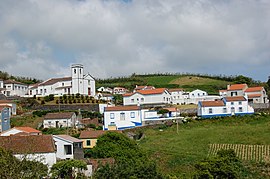
The landscape of Santa Bárabara on the slopes of the Sete Cidades massif
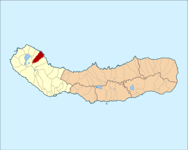
The location of the civil parish of Santa Bárbara in the municipality of Ponta Delgada
Coordinates: 37°52′28N 25°43′34W / 37.87444°N 25.72611°W / 37.87444; -25.72611
Country Portugal
Auton. regionAzores
IslandSão Miguel
MunicipalityPonta Delgada
EstablishedSettlement: fl. 1600
Parish: 1 April 1986
Area
 • Total8.72 km2 (3.37 sq mi)
Elevation
247 m (810 ft)
Population
 (2011)
 • Total855
 • Density98/km2 (250/sq mi)
Time zoneUTC−01:00 (AZOT)
 • Summer (DST)UTC±00:00 (AZOST)
Postal code
9545-321
Area code292
PatronSanta Bárbara

Santa Bárbara is a civil parish in the municipalityofPonta Delgada on the Portuguese island of São Miguel in the Azores. The population in 2011 was 855,[1] in an area of 8.72 km².[2] Santa Barbara is a relatively young administrative entity, established in 1986, being de-annexed from the neighboring parish of Santo António.

Geography[edit]

Santa Bárbara is sandwiched between Santo António (along the east and south), Remédios in the northwest, Sete Cidades to the southwest, and the Atlantic Ocean to the north. It is located in the northwestern part of the island of São Miguel. Apart from its church (to the invocation of Santa Bárbara), along with a few small commercial businesses, there is a restaurant and a local soccer field.

References[edit]


Retrieved from "https://en.wikipedia.org/w/index.php?title=Santa_Bárbara_(Ponta_Delgada)&oldid=952398192"

Category: 
Parishes of Ponta Delgada
Hidden categories: 
Pages using gadget WikiMiniAtlas
Articles with short description
Short description is different from Wikidata
Coordinates on Wikidata


This page was last edited on 22 April 2020, at 01:20 (UTC).

Text is available under the Creative Commons Attribution-ShareAlike License 4.0; additional terms may apply. By using this site, you agree to the Terms of Use and Privacy Policy. Wikipedia® is a registered trademark of the Wikimedia Foundation, Inc., a non-profit organization.


Privacy policy

About Wikipedia

Disclaimers

Contact Wikipedia

Code of Conduct

Developers

Statistics

Cookie statement

Mobile view


Wikimedia Foundation
Powered by MediaWiki