●Create account
●Log in
●Create account
● Log in
Pages for logged out editors learn more
●Contributions
●Talk
Contents
(Top) 1 See also 2 ReferencesSanta Maria do Herval
●閩南語 / Bân-lâm-gú ●Cebuano ●Deutsch ●Español ●Esperanto ●Euskara ●Français ●Հայերեն ●বিষ্ণুপ্রিয়া মণিপুরী ●Italiano ●Қазақша ●Magyar ●Malagasy ●Nederlands ●Нохчийн ●Norsk bokmål ●Polski ●Português ●Română ●Русский ●Scots ●Simple English ●Svenska ●Татарча / tatarça ●Tiếng Việt ●Winaray ●中文 Edit links ●Article ●Talk ●Read ●Edit ●View history Tools Actions ●Read ●Edit ●View history General ●What links here ●Related changes ●Upload file ●Special pages ●Permanent link ●Page information ●Cite this page ●Get shortened URL ●Download QR code ●Wikidata item Print/export ●Download as PDF ●Printable version In other projects ●Wikimedia Commons Appearance Coordinates: 29°29′52″S 50°59′34″W / 29.49778°S 50.99278°W From Wikipedia, the free encyclopedia
Santa Maria do Herval
Teewald (Hunsrick)
| |
|---|---|
| Municipality of Santa Maria do Herval | |
 | |
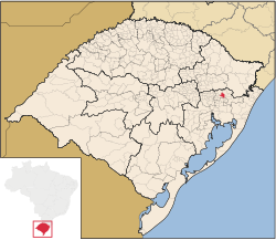
 Location within Rio Grande do Sul | |
| Coordinates: 29°29′52″S 50°59′34″W / 29.49778°S 50.99278°W | |
| Country | |
| State | |
| Population (2020)[1] | |
| • Total | 6,364 |
| Time zone | UTC−3 (BRT) |
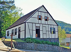
Santa Maria do Herval (Hunsrick: Teewald) is a municipality in the state of Rio Grande do Sul, Brazil.
Santa Maria do Herval is one of 17 municipalities in Brazil where Hunsrick is an official language.


