Jump to content


Main menu


Navigation  


Main page
Contents
Current events
Random article
About Wikipedia
Contact us
Donate


Contribute  


Help
Learn to edit
Community portal
Recent changes
Upload file


Search  


Create account

Log in


Create account
 Log in


Pages for logged out editors learn more  


Contributions
Talk


Contents


(Top)


1 Geography  


2 People  


3 History  


4 References  


5 Bibliography  


6 External links  


Sattagydia


Català
Español
فارسی

Hrvatski
Italiano
Русский
Slovenščina
Srpskohrvatski / српскохрватски
Українська
 

Edit links


Article
Talk


Read
Edit
View history


Tools


Actions  


Read
Edit
View history


General  


What links here
Related changes
Upload file
Special pages
Permanent link
Page information
Cite this page
Get shortened URL
Download QR code
Wikidata item


Print/export  


Download as PDF
Printable version


Appearance


From Wikipedia, the free encyclopedia


Sattagydia
𐎰𐎫𐎦𐎢𐏁
Sāttagydiⁿa (Old Persian)
Satrapy of the Achaemenid Empire
513 BCE–c. 4th century BCE

Flag of


Standard of Cyrus the Great


Sāttagydiⁿa was part of the eastern territories of the Achaemenid Empire
Government
 • TypeMonarchy
King or
King of Kings
 

• 513–499 BCE

Darius I (first)

• 358–338 BC

Artaxerxes III
Historical eraAchaemenid era

• Achaemenid conquest of the Indus Valley

513 BCE

• Disestablished

c. 4th century BCE
Preceded by
Succeeded by
Achaemenid Empire
Macedonian Empire
Today part of Pakistan
Sattagydia
Sattagydia (𓐠𓂧𓎼𓍯𓍒𓈉, S-d-g-wꜣ-ḏꜣ), on the Egyptian Statue of Darius I.[1][2]
Sattagydian Achaemenid soldier
Xerxes I tomb, Sattagydian soldier of the Achaemenid army, circa 480 BCE.[3][4]
Xerxes I tomb, Sattagydian soldier circa 480 BCE (detail).
The name for Sattagydia (𐎰𐎫𐎦𐎢𐏁, Thataguš) in the DNa inscriptionofDarius I.

Sattagydia (Old Persian: 𐎰𐎫𐎦𐎢𐏁 Thataguš, country of the "hundred cows") was one of the easternmost regions of the Achaemenid Empire, part of its Seventh tax district according to Herodotus,[5] along with Gandārae, Dadicae and Aparytae.[6][7][8] It was situated east of the Sulaiman Mountains up to the Indus River in the basin around Bannu in modern day's southern Khyber Pakhtunkhwa, Pakistan.[9]

Geography[edit]

The location of Sattagydia has been subject to debate. Its association with Gandara in the 7th tax district of the Herodotus list implies that it was close to Gandara. Olmstead believed that it stretched from "the lower slopes of the Hindu Kush".[10] Based on these considerations, two locations have been proposed: the first being "the area of the confluence of the Ghorband and Panjshir rivers in Afghanistan", and the second, "the area of the middle Indus, around the modern city of Bannu".[11]

Following recent archaeological findings, the Bannu basin has become the favoured choice. David Fleming points out that it is close to Kurram and Tochi rivers and it has four routes to the west, via the Khyber Pass, the Kurram river valley, the Gomal Pass and the Bolan Pass in Balochistan.[9] Magee et al. have reported findings of recent archaeological excavations at Akra, noting that it was a large urban site that existed throughout the Iron Age and had trade relations with Central Asia.[12]

People[edit]

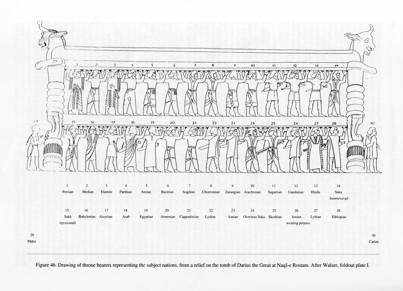
Representatives of Sattagydia are depicted as delegates bringing gifts to the king on the Apadana staircases, and as throne/ dais bearers on the Tripylon and Hall of One Hundred Columns reliefs at Persepolis. The representatives of Sattagydia are characterized by their loincloths, sandals, and exposed upper body, which distinguish them from the representatives of other eastern provinces such as Bactria and Arachosia.[13]

History[edit]

Sattagydia is mentioned for the first time in the Behistun inscriptionofDarius the Great as one of the provinces in revolt while the king was in Babylon. The revolt was presumably suppressed in 515 BCE. The satrapy disappears from sources after 480 BCE, possible being mentioned by another name or included with other regions.[14][unreliable source?]

After being conquered by Alexander the Great, Sattagydia became part of the Seleucid Empire. Under the Seleucids this area was adjacent to Sind, which was itself adjacent to Abiria (corresponding roughly to Rajasthan), with the coastal region being called Syrastrene.[15] The area was taken from the Seleucids by the Mauryans under Chandragupta in 316 BCE.[16][need quotation to verify][17] And, beginning in the 1st century BC, the area was incorporated into the burgeoning Kushan Empire, referred to as "Scythia" in the Periplus.[15]

References[edit]

  1. ^ "Susa, Statue of Darius - Livius". www.livius.org.
  • ^ Yar-Shater, Ehsan (1982). Encyclopaedia Iranica. Routledge & Kegan Paul. p. 10. ISBN 9780933273955.
  • ^ Naqs-e Rostam – Encyclopaedia Iranica.
  • ^ Naqs-e Rostam – Encyclopaedia Iranica List of nationalities of the Achaemenid military with corresponding drawings.
  • ^ Herodotus III 91, III 94
  • ^ Mitchiner, Michael (1978). The ancient & classical world, 600 B.C.-A.D. 650. Hawkins Publications ; distributed by B. A. Seaby. p. 44. ISBN 9780904173161.
  • ^ Jigoulov, Vadim S. (2016), The Social History of Achaemenid Phoenicia: Being a Phoenician, Negotiating Empires, Routledge, p. 21, ISBN 978-1-134-93809-4
  • ^ Eggermont, Alexander's Campaigns in Sind and Baluchistan 1975.
  • ^ a b Fleming, Achaemenid Sattagydia 1982, p. 105.
  • ^ Olmstead, History of the Persian Empire 1948, pp. 48–49.
  • ^ Fleming, Achaemenid Sattagydia 1982, p. 103.
  • ^ Magee et al., The Achaemenid Empire in South Asia and Recent Excavations 2005, p. 735.
  • ^ Magee et al., The Achaemenid Empire in South Asia and Recent Excavations 2005, p. 713.
  • ^ "Sattagydians - Livius". www.livius.org.
  • ^ a b Periplus of the Erythraean Sea[non-primary source needed]
  • ^ De La Fosse, Claude Fraser, (1917) History of India (revised edition) Macmillan & Co., London, pp. 39-42, OCLC 13241962
  • ^ see also, Junianus Justinus Historiarum Philippicarum libri XLIV, XV.4.19[non-primary source needed]
  • Bibliography[edit]

    External links[edit]


    Retrieved from "https://en.wikipedia.org/w/index.php?title=Sattagydia&oldid=1234388999"

    Categories: 
    States and territories established in the 6th century BC
    Achaemenid satrapies
    Historical geography of Pakistan
    Ancient history of Pakistan
    Archaeological sites in Pakistan
    Ancient Asia
    History of Khyber Pakhtunkhwa
    Historical regions of Pakistan
    Hidden categories: 
    All pages needing factual verification
    Wikipedia articles needing factual verification from October 2018
    Articles with short description
    Short description is different from Wikidata
    Articles containing Old Persian (ca. 600-400 B.C.)-language text
    Former country articles requiring maintenance
    All articles lacking reliable references
    Articles lacking reliable references from October 2018
    Afghanistan articles missing geocoordinate data
    All articles needing coordinates
    Articles missing coordinates without coordinates on Wikidata


    This page was last edited on 14 July 2024, at 03:10 (UTC).

    Text is available under the Creative Commons Attribution-ShareAlike License 4.0; additional terms may apply. By using this site, you agree to the Terms of Use and Privacy Policy. Wikipedia® is a registered trademark of the Wikimedia Foundation, Inc., a non-profit organization.


    Privacy policy

    About Wikipedia

    Disclaimers

    Contact Wikipedia

    Code of Conduct

    Developers

    Statistics

    Cookie statement

    Mobile view


    Wikimedia Foundation
    Powered by MediaWiki