Jump to content


Main menu


Navigation  


Main page
Contents
Current events
Random article
About Wikipedia
Contact us
Donate


Contribute  


Help
Learn to edit
Community portal
Recent changes
Upload file


Search  


Create account

Log in


Create account
 Log in


Pages for logged out editors learn more  


Contributions
Talk


Contents


(Top)


1 See also  


2 References  


Sayacmarca


Español
 

Edit links


Article
Talk


Read
Edit
View history


Tools


Actions  


Read
Edit
View history


General  


What links here
Related changes
Upload file
Special pages
Permanent link
Page information
Cite this page
Get shortened URL
Download QR code
Wikidata item


Print/export  


Download as PDF
Printable version


In other projects  


Wikimedia Commons


Appearance


Coordinates: 13°1341.4S 72°3100.9W / 13.228167°S 72.516917°W / -13.228167; -72.516917
 

From Wikipedia, the free encyclopedia


Sayacmarca
Partial view of Sayacmarca.
Sayacmarca is located in Peru
Sayacmarca

Shown within Peru

Location Peru
Cusco Region
TypeSettlement
History
CulturesInca

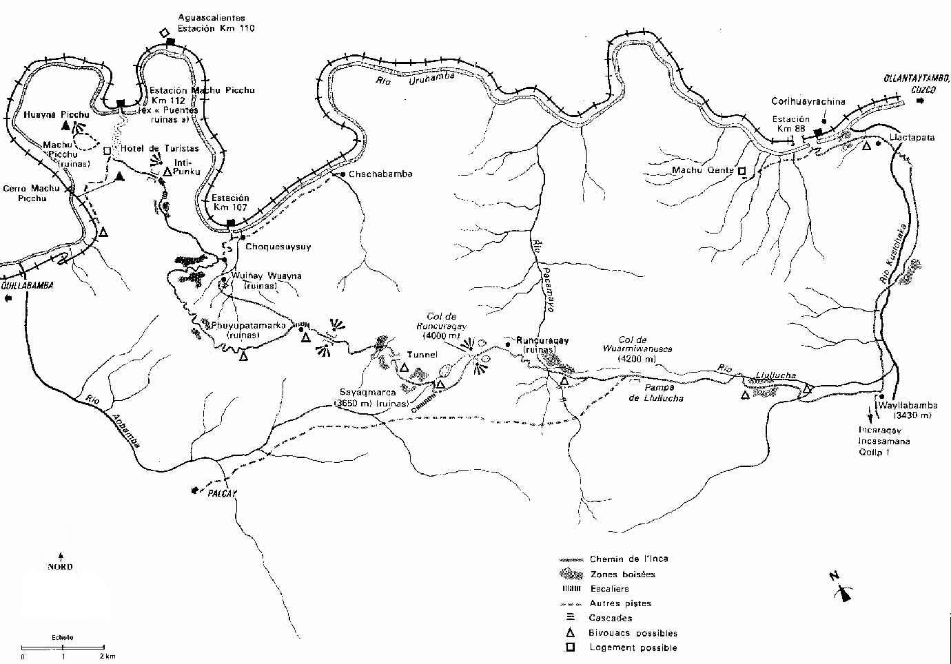
Sayacmarca[1][2][3] is an archaeological site in Peru located in the Cusco Region, Urubamba Province, Machupicchu District. It is situated southwest of the archaeological site Runkuraqay and the Runkuraqay pass and southeast of the sites Phuyupatamarka and Qunchamarka.[4][5]

Hiram Bingham III visited the site in April 1915, referring to it as Cedrobamba, or cedar plain.[6]

See also

[edit]

References

[edit]
  1. ^ Nair, Stella (2015). At Home with the Sapa Inca: Architecture, Space, and Legacy at Chinchero. University of Texas Press. p. 207. ISBN 9781477302507.
  • ^ Bradt, Hilary; Jarvis, Kathy (2014). Trekking in Peru: 50 Best Walks and Hikes. Bradt Travel Guides. pp. 290, 296. ISBN 9781841624921.
  • ^ Kaufmann, H. W.; Kaufmann, J. E. (2012). Fortifications of the Incas: 1200–1531. Bloomsbury Publishing. p. 37. ISBN 9781849080460.
  • ^ nroirand.free.fr Sketch map of the Inca trail
  • ^ escale.minedu.gob.pe - UGEL map of the Urubamba Province (Cusco Region)
  • ^ Bingham, Hiram (1952). Lost City of the Incas. Weidenfeld & Nicolson. pp. 22, 253-254. ISBN 9781842125854.
  • Location of Sayacmarca as shown on a sign near Willkaraqay

    13°13′41.4″S 72°31′00.9″W / 13.228167°S 72.516917°W / -13.228167; -72.516917


  • t
  • e
  • t
  • e

  • Retrieved from "https://en.wikipedia.org/w/index.php?title=Sayacmarca&oldid=1074068991"

    Categories: 
    Archaeological sites in Peru
    Archaeological sites in Cusco Region
    Peruvian history stubs
    South American archaeology stubs
    Hidden categories: 
    Pages using gadget WikiMiniAtlas
    Articles with short description
    Short description matches Wikidata
    Coordinates on Wikidata
    All stub articles


    This page was last edited on 26 February 2022, at 07:12 (UTC).

    Text is available under the Creative Commons Attribution-ShareAlike License 4.0; additional terms may apply. By using this site, you agree to the Terms of Use and Privacy Policy. Wikipedia® is a registered trademark of the Wikimedia Foundation, Inc., a non-profit organization.


    Privacy policy

    About Wikipedia

    Disclaimers

    Contact Wikipedia

    Code of Conduct

    Developers

    Statistics

    Cookie statement

    Mobile view


    Wikimedia Foundation
    Powered by MediaWiki