Jump to content


Main menu


Navigation  


Main page
Contents
Current events
Random article
About Wikipedia
Contact us
Donate


Contribute  


Help
Learn to edit
Community portal
Recent changes
Upload file


Search  


Create account

Log in


Create account
 Log in


Pages for logged out editors learn more  


Contributions
Talk


Contents


(Top)


1 Geography  


1.1  Civil parishes  


2 History and monuments  


3 Demography  


4 Economy and infrastructure  


4.1  Transport  


4.2  Business  


5 Politics  


5.1  Twin towns  Sister cities  


6 Education  


7 Notable people  


8 See also  


9 References  


10 Sources  


11 External links  


Schönefeld


Afrikaans
Català
Cebuano
Dansk
Deutsch
Eesti
Español
Esperanto
Euskara
فارسی
Français
Հայերեն
Hornjoserbsce
Interlingue
Italiano
עברית
Kurdî
Magyar
Македонски
Bahasa Melayu
Nederlands
Нохчийн
Polski
Português
Română
Русский
Српски / srpski
Srpskohrvatski / српскохрватски
Svenska
Татарча / tatarça
Українська
اردو
Tiếng Vit
Winaray


Edit links


Article
Talk


Read
Edit
View history


Tools


Actions  


Read
Edit
View history


General  


What links here
Related changes
Upload file
Special pages
Permanent link
Page information
Cite this page
Get shortened URL
Download QR code
Wikidata item


Print/export  


Download as PDF
Printable version


In other projects  


Wikimedia Commons


Appearance


Coordinates: 52°2318N 13°3017E / 52.38833°N 13.50472°E / 52.38833; 13.50472
 

From Wikipedia, the free encyclopedia


Schönefeld
Schönefeld village church
Coat of arms of Schönefeld
Location of Schönefeld within Dahme-Spreewald district
Alt Zauche-WußwerkBerstelandBestenseeByhleguhre-ByhlenDrahnsdorfEichwaldeGolßenGroß KörisHalbeHeideblickHeideseeJamlitzKasel-GolzigKönigs WusterhausenKrausnick-Groß WasserburgLieberoseLübbenLuckauMärkisch BuchholzMärkische HeideMittenwaldeMünchehofeNeu ZaucheRietzneuendorf-StaakowSchlepzigSchönefeldSchönwaldSchulzendorfSchwerinSchwielochseeSpreewaldheideSteinreichStraupitz (Spreewald)TeupitzUnterspreewaldWildauZeuthenBrandenburg
Schönefeld is located in Germany
Schönefeld

Schönefeld

Schönefeld is located in Brandenburg
Schönefeld

Schönefeld

Coordinates: 52°23′18N 13°30′17E / 52.38833°N 13.50472°E / 52.38833; 13.50472
CountryGermany
StateBrandenburg
DistrictDahme-Spreewald
Subdivisions6Ortsteile
Government
 • Mayor (2019–27) Christian Hentschel[1]
Area
 • Total81.57 km2 (31.49 sq mi)
Elevation
44 m (144 ft)
Population
 (2022-12-31)[2]
 • Total19,174
 • Density240/km2 (610/sq mi)
Time zoneUTC+01:00 (CET)
 • Summer (DST)UTC+02:00 (CEST)
Postal codes
12529
Dialling codes030, 03379, 033762
Vehicle registrationLDS
WebsiteOfficial website

Schönefeld (meaning beautiful field) is a suburban municipality in the Dahme-Spreewald district, Brandenburg, Germany. It borders the southeastern districts of Berlin. The municipal area encompasses the old Berlin Schönefeld Airport (SXF) and the new Berlin Brandenburg Airport (BER).

Geography[edit]

It is located about 22 km (14 mi) southeast of the Berlin city centre, next to Berlin's only airport, Berlin Brandenburg Airport (BER).

In the north, Schönefeld adjoins to the Berlin boroughsofTempelhof-Schöneberg, Neukölln, and Treptow-Köpenick with the localities of Lichtenrade, Gropiusstadt, Buckow, Rudow, Altglienicke, and Bohnsdorf. In the south, it borders Mittenwalde, in the west, Blankenfelde-Mahlow and in the east, Schulzendorf and Zeuthen.

Civil parishes[edit]

The Schönefeld municipal area comprises six districts (Ortsteile), former municipalities in their own right which were incorporated in 2003:

The settlement of Kienberg, part of Waltersdorf, was cleared of residents to permit expansion of the Berlin Brandenburg Airport and is to be developed as a commercial area.

History and monuments[edit]

The first preserved mention of Schönefeld in the Mittelmark territory dates back to 1242. Sconenfelde, then a possession held by the Lords of Selchow, is documented in the 1375 Landbuch (domesday book) of Emperor Charles IV, when he also ruled as Elector of Brandenburg. The village church, rebuilt in 1904/05 according to plans designed by Franz Heinrich Schwechten, includes a large Baroque altar. Waltersdorf and Waßmannsdorf also have village churches dating to the first half of the 13th century.

From 1933 onwards the Henschel aircraft company moved from Johannisthal Air Field to Schönefeld and had three runways laid out next to the village. More than 14,000 warplanes were built at the site until 1945, when the premises were occupied by the Red Army. In the Großziethen cemetery is a memorial to 200 prisoners of war and forced laborers who died during World War II. The Soviet Air Forces used the air field from 1946, one year later the Soviet Military Administration ordered the buildup of a civil air service supplying East Berlin.

Before German reunification, Schönefeld shared its borders partly with boroughs of former West Berlin (present-day Neukölln and Tempelhof-Schöneberg[3]), and so from 1961 to 1990 it was separated from it by the Berlin Wall.[4][5]
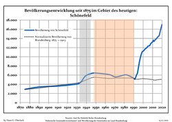
Demography[edit]

Schönefeld: Population development
within the current boundaries (2017)[6]
YearPop.±% p.a.
1875 2,903—    
1890 3,415+1.09%
1910 3,613+0.28%
1925 3,918+0.54%
1933 4,278+1.10%
1939 5,811+5.24%
1946 6,397+1.38%
1950 6,446+0.19%
1964 6,117−0.37%
1971 5,605−1.24%
1981 6,068+0.80%
1985 5,857−0.88%
1989 5,449−1.79%
1990 5,312−2.51%
1991 5,128−3.46%
YearPop.±% p.a.
1992 5,450+6.28%
1993 6,023+10.51%
1994 6,456+7.19%
1995 7,619+18.01%
1996 8,772+15.13%
1997 9,752+11.17%
1998 10,496+7.63%
1999 11,059+5.36%
2000 11,218+1.44%
2001 11,405+1.67%
2002 11,667+2.30%
2003 11,843+1.51%
2004 11,993+1.27%
2005 12,274+2.34%
2006 12,354+0.65%
YearPop.±% p.a.
2007 12,462+0.87%
2008 12,831+2.96%
2009 13,060+1.78%
2010 13,256+1.50%
2011 13,317+0.46%
2012 13,453+1.02%
2013 13,760+2.28%
2014 13,895+0.98%
2015 14,190+2.12%
2016 14,423+1.64%
2017 14,625+1.40%
2018 15,472+5.79%
2019 16,270+5.16%
2020 17,017+4.59%

Economy and infrastructure[edit]

Transport[edit]

Business[edit]

The Airport-Center, an industrial area in Waltersdorf, and Berlin Brandenburg Airport are important sources of revenue for Schönefeld.[citation needed]

The head office of Private Wings is located in the General Aviation Terminal (Allgemeine Luftfahrt) on the property of Schönefeld Airport.[7][8][9] Before its disestablishment, the East German airline company Interflug had its head office on the grounds of the airport.[10] Bremenfly also had its head office in Schönefeld.[11]

Politics[edit]

Town hall

Seats in the municipal council (Gemeinderat):

Twin towns — Sister cities[edit]

Schönefeld is twinned with Mongolia Bayangol, a district of Ulaanbataar, since 1999.[12]

Education[edit]

Primary schools in the municipality:

There is a private secondary school, Evangelische Schule Schönefeld.[15]

Notable people[edit]

See also[edit]

References[edit]

  • ^ "Bevölkerungsentwicklung und Bevölkerungsstandim Land Brandenburg Dezember 2022" (PDF). Amt für Statistik Berlin-Brandenburg (in German). June 2023.
  • ^ Source: "ADAC StadtAtlas – Berlin-Potsdam". ed. 2007 – pages 232, 233, 234 – ISBN 3-8264-1348-2
  • ^ Map and info about the wall on "Berlin Wall Online" (in German)
  • ^ Info, maps and pictures (see the sections "Lichterfelde-Schönefeld" and "Schönefeld-East Side Gallery")
  • ^ Detailed data sources are to be found in the Wikimedia Commons.Population Projection Brandenburg at Wikimedia Commons
  • ^ "Anfahrt GAT Schönefeld." Private Wings. Retrieved on 7 January 2013.
  • ^ "Access Business Aviation Center/GAT." Private Wings. Retrieved on 7 January 2013.
  • ^ "Imprint." Private Wings. Retrieved on 7 January 2013. "Postal adress: [sic] PRIVATE WINGS Flugcharter GmbH Chief executive officers: Peter Paul Gatz und Andreas Wagner Flughafen Berlin – Schönefeld 12521 Berlin, Germany" and "Delivery address: Private Wings Flugcharter GmbH Waßmannsdorfer Straße 12529 Schönefeld (ehemals Diepensee)"
  • ^ "World Airline Directory," Flight International, 26 March 1988, p. 82. (pdf)
  • ^ "Kontakt." Bremenfly. 27 August 2010. Retrieved on 7 January 2012. "Zeppelinstr. 1 Berlin-Schönefeld 12529 Deutschland"
  • ^ Partnerstadt Bayangol (Twin city Bayangol) on the city's official homepage, accessed 22 July 2014
  • ^ "Astrid-Lindgren-Grundschule Schönefeld." Schönefeld. Retrieved on September 13, 2016.
  • ^ "Paul-Maar-Grundschule Großziethen." Schönefeld. Retrieved on September 13, 2016.
  • ^ "Evangelische Schule Schönefeld – Gymnasium." Schönefeld. Retrieved on September 13, 2016.
  • Sources[edit]

    External links[edit]

    Media related to Schönefeld at Wikimedia Commons


    Retrieved from "https://en.wikipedia.org/w/index.php?title=Schönefeld&oldid=1190000639"

    Categories: 
    Municipalities in Brandenburg
    Localities in Dahme-Spreewald
    Teltow (region)
    Hidden categories: 
    Pages using gadget WikiMiniAtlas
    CS1 German-language sources (de)
    Articles with German-language sources (de)
    Articles with short description
    Short description is different from Wikidata
    Coordinates on Wikidata
    Official website different in Wikidata and Wikipedia
    All articles with unsourced statements
    Articles with unsourced statements from January 2013
    Wikipedia articles in need of updating from June 2021
    All Wikipedia articles in need of updating
    Commons category link is on Wikidata
    Articles with VIAF identifiers
    Articles with GND identifiers
    Articles with NKC identifiers
    Articles with MusicBrainz area identifiers


    This page was last edited on 15 December 2023, at 09:12 (UTC).

    Text is available under the Creative Commons Attribution-ShareAlike License 4.0; additional terms may apply. By using this site, you agree to the Terms of Use and Privacy Policy. Wikipedia® is a registered trademark of the Wikimedia Foundation, Inc., a non-profit organization.


    Privacy policy

    About Wikipedia

    Disclaimers

    Contact Wikipedia

    Code of Conduct

    Developers

    Statistics

    Cookie statement

    Mobile view


    Wikimedia Foundation
    Powered by MediaWiki