Jump to content


Main menu


Navigation  


Main page
Contents
Current events
Random article
About Wikipedia
Contact us
Donate


Contribute  


Help
Learn to edit
Community portal
Recent changes
Upload file


Search  


Create account

Log in


Create account
 Log in


Pages for logged out editors learn more  


Contributions
Talk


Contents


(Top)


1 History  


1.1  Name  


2 Media gallery  


3 References  


Sem, Norway


Cebuano
Español
Français
Bahasa Melayu
Nederlands
Norsk bokmål
Norsk nynorsk
Română
Suomi
Svenska
Українська
 

Edit links


Article
Talk


Read
Edit
View history


Tools


Actions  


Read
Edit
View history


General  


What links here
Related changes
Upload file
Special pages
Permanent link
Page information
Cite this page
Get shortened URL
Download QR code
Wikidata item


Print/export  


Download as PDF
Printable version


In other projects  


Wikimedia Commons


Appearance


Coordinates: 59°1656N 10°1948E / 59.2823°N 10.33004°E / 59.2823; 10.33004
 

From Wikipedia, the free encyclopedia


Sem
Semsbyen
Village
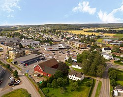
View of the village
View of the village
Sem is located in Vestfold
Sem

Sem

Location of the village

Sem is located in Norway
Sem

Sem

Sem (Norway)

Coordinates: 59°16′56N 10°19′48E / 59.2823°N 10.33004°E / 59.2823; 10.33004
CountryNorway
RegionEastern Norway
CountyVestfold
DistrictJarlsberg
MunicipalityTønsberg Municipality
Area
 • Total2.02 km2 (0.78 sq mi)
Elevation 18 m (59 ft)
Population
 (2023)[1]
 • Total2,733
 • Density1,350/km2 (3,500/sq mi)
Time zoneUTC+01:00 (CET)
 • Summer (DST)UTC+02:00 (CEST)
Post Code
3170 Sem

SemorSemsbyen is a village in Tønsberg MunicipalityinVestfold county, Norway. The village is located about 5 kilometres (3.1 mi) to the west of the city of Tønsberg. The village of Vear lies about 3 kilometres (1.9 mi) to the southeast of Sem, along the shore of the Tønsbergfjorden. The historic Sem Church is located just northeast of the village.[3]

The village lies along the border with Sandefjord Municipality to the southwest (in fact, a small portion of the urban area of Sem crosses over the border and has about 50 residents in the neighboring municipality). The 2.02-square-kilometre (500-acre) village has a population (2023) of 2,733 and a population density of 1,350 inhabitants per square kilometre (3,500/sq mi).[1]

The village of Sem was the administrative centre of the old Sem Municipality which existed from 1838 until 1988 when it became part of Tønsberg Municipality.[3]

History

[edit]

The historic Sem Manor (Sem hovedgård) is located just outside the present-day village. During the Middle Ages, Sem Manor was the residence of a royal and feudal overlord at the site where Jarlsberg Manor is located today. King Harald Fairhair chose to install his son Bjorn Farmann as the master of the estate. It was here that Bjorn Farmann was killed by Eric Bloodaxe in 927. In 1673, Peder Schumacher Griffenfeld took over the property which until then had belonged to the King of Denmark. Griffenfeldt named the farm Griffenfeldgård, but three years later it was renamed Jarlsberg Manor (Jarlsberg Hovedgård). In 1682, the buildings on Jarlsberg burned and new buildings of stone were built by the new owner, the Danish-Norwegian Field Marshal Wilhelm Gustav Wedel.[4]

Name

[edit]

The village (originally the parish) is named after the old Sem farm (Old Norse: Sæmr, a compressed form of Sæheimr) since the first Sem Church was built there. The first element is sær which means "sea" or "ocean", likely referring to the local Tønsbergfjorden. The last element is heimr which means "home" or "abode".[5]

[edit]

References

[edit]
  1. ^ a b c Statistisk sentralbyrå (1 January 2023). "Urban settlements. Population and area, by municipality".
  • ^ "Sem, Tønsberg". yr.no. Retrieved 3 February 2024.
  • ^ a b Thorsnæs, Geir, ed. (20 December 2023). "Sem (tettsted i Tønsberg)". Store norske leksikon (in Norwegian). Kunnskapsforlaget. Retrieved 3 February 2024.
  • ^ Bratberg, Terje, ed. (17 October 2023). "Jarlsberg". Store norske leksikon (in Norwegian). Kunnskapsforlaget. Retrieved 3 February 2024.
  • ^ Rygh, Oluf (1907). Norske gaardnavne: Jarlsberg og Larviks amt (in Norwegian) (6 ed.). Kristiania, Norge: W. C. Fabritius & sønners bogtrikkeri. p. 208.


  • Retrieved from "https://en.wikipedia.org/w/index.php?title=Sem,_Norway&oldid=1203010344"

    Categories: 
    Tønsberg
    Villages in Vestfold
    Hidden categories: 
    Pages using gadget WikiMiniAtlas
    CS1 Norwegian-language sources (no)
    Articles with short description
    Short description is different from Wikidata
    Coordinates on Wikidata
    Articles containing Norwegian-language text
    Articles containing Old Norse-language text
    Use dmy dates from February 2024


    This page was last edited on 4 February 2024, at 01:01 (UTC).

    Text is available under the Creative Commons Attribution-ShareAlike License 4.0; additional terms may apply. By using this site, you agree to the Terms of Use and Privacy Policy. Wikipedia® is a registered trademark of the Wikimedia Foundation, Inc., a non-profit organization.


    Privacy policy

    About Wikipedia

    Disclaimers

    Contact Wikipedia

    Code of Conduct

    Developers

    Statistics

    Cookie statement

    Mobile view


    Wikimedia Foundation
    Powered by MediaWiki