Jump to content


Main menu


Navigation  


Main page
Contents
Current events
Random article
About Wikipedia
Contact us
Donate


Contribute  


Help
Learn to edit
Community portal
Recent changes
Upload file


Search  


Create account

Log in


Create account
 Log in


Pages for logged out editors learn more  


Contributions
Talk


Contents


(Top)


1 Description  


2 Protected areas  


3 See also  


4 References  


5 External links  


Sierra de Aracena


Català
Cebuano
Deutsch
Español
Esperanto
Français
Қазақша
Oʻzbekcha / ўзбекча
Русский
Svenska


Edit links


Article
Talk


Read
Edit
View history


Tools


Actions  


Read
Edit
View history


General  


What links here
Related changes
Upload file
Special pages
Permanent link
Page information
Cite this page
Get shortened URL
Download QR code
Wikidata item


Print/export  


Download as PDF
Printable version


In other projects  


Wikimedia Commons


Appearance


Coordinates: 37°54N 6°37W / 37.900°N 6.617°W / 37.900; -6.617
 

From Wikipedia, the free encyclopedia


Sierra de Aracena
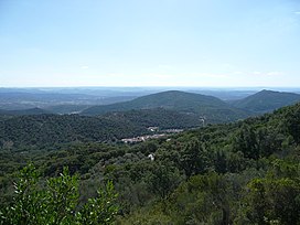
Landscape of Sierra de Aracena with the ubiquitous small village in the valley
Highest point
PeakCerro del Castaño
Elevation962 m (3,156 ft)
Coordinates33°57′35N 6°35′7W / 33.95972°N 6.58528°W / 33.95972; -6.58528
Dimensions
Length58 km (36 mi) NW/SE
Width15 km (9.3 mi) NE/SW
Geography
Sierra de Aracena is located in Spain
Sierra de Aracena

Sierra de Aracena

Location in Spain

LocationAndalusia
CountrySpain
Range coordinates37°54′N 6°37′W / 37.900°N 6.617°W / 37.900; -6.617
Parent rangeSierra Morena
Geology
OrogenyVariscan orogeny
Age of rockPaleozoic
Type of rockSchist, slate and quartzite

Sierra de Aracena is the westernmost mountain range of the Sierra Morena, Andalusia, Spain. It is located in the northern part of Huelva Province.

The range is named after the town of Aracena.

Description[edit]

The Sierra de Aracena is not very high and its mountains have a gentle, rounded shape. The height of most of the summits lies between 400 and 900 m (1,300 and 3,000 ft). Its highest point is 962 m (3,156 ft) high Cerro del Castaño.[1] Other notable summits are Cerro de San Cristóbal 917 m (3,009 ft) and Cerro de Santa Bárbara 814 m (2,671 ft), the latter located close to Cortegana. The Odiel and Murtigas are the main rivers in the area of the range.[2]

The climate is relatively humid for Andalusian standards and there is a small village in most of the valleys. The undisturbed slopes of the mountains are mostly covered in forest, which is made up of Chestnut, Holm Oak and Cork Oak trees.[3]

Protected areas[edit]

The Sierra de Aracena and Picos de Aroche Natural Park is located in the area of the range.

See also[edit]

References[edit]

  • ^ Park entry at Regional Government official site
  • ^ Sierra de Aracena (in German)
  • External links[edit]

  • t
  • e

  • Retrieved from "https://en.wikipedia.org/w/index.php?title=Sierra_de_Aracena&oldid=997555757"

    Categories: 
    Sierra Morena
    Mountain ranges of Andalusia
    Andalusia geography stubs
    Hidden categories: 
    Pages using gadget WikiMiniAtlas
    Coordinates on Wikidata
    Inconsistent wikidata for Commons category
    All stub articles


    This page was last edited on 1 January 2021, at 03:02 (UTC).

    Text is available under the Creative Commons Attribution-ShareAlike License 4.0; additional terms may apply. By using this site, you agree to the Terms of Use and Privacy Policy. Wikipedia® is a registered trademark of the Wikimedia Foundation, Inc., a non-profit organization.


    Privacy policy

    About Wikipedia

    Disclaimers

    Contact Wikipedia

    Code of Conduct

    Developers

    Statistics

    Cookie statement

    Mobile view


    Wikimedia Foundation
    Powered by MediaWiki