Jump to content


Main menu


Navigation  


Main page
Contents
Current events
Random article
About Wikipedia
Contact us
Donate


Contribute  


Help
Learn to edit
Community portal
Recent changes
Upload file


Search  


Create account

Log in


Create account
 Log in


Pages for logged out editors learn more  


Contributions
Talk


Contents


(Top)


1 Notes  


Simeto


العربية
Чӑвашла
Cebuano
Deutsch
Español
Esperanto
Français
Italiano
Latina
Polski
Português
Русский
Sicilianu
Srpskohrvatski / српскохрватски


Edit links


Article
Talk


Read
Edit
View history


Tools


Actions  


Read
Edit
View history


General  


What links here
Related changes
Upload file
Special pages
Permanent link
Page information
Cite this page
Get shortened URL
Download QR code
Wikidata item


Print/export  


Download as PDF
Printable version


In other projects  


Wikimedia Commons


Appearance


Coordinates: 37°2401N 15°0520E / 37.4003°N 15.0890°E / 37.4003; 15.0890
 

From Wikipedia, the free encyclopedia


Simeto
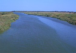
The river's mouth
Location
CountryItaly
Physical characteristics
Source 
 • locationNebrodi Mountains
 • elevationabout 1,700 m (5,600 ft)
MouthIonian Sea

 • coordinates

37°24′01N 15°05′20E / 37.4003°N 15.0890°E / 37.4003; 15.0890
Length116 km (72 mi)
Basin size4,029 km2 (1,556 sq mi)
Discharge 
 • average25 m3/s (880 cu ft/s)

The Simeto (Italian pronunciation: [siˈmɛːto]; Sicilian: Simetu; Latin: Symaethus; Greek: Σύμαιθος) is a 113-kilometre (70 mi) long river in Sicily, southern Italy. At 116 kilometres (72 mi), it is the second longest river on the island after the Salso (also known as Southern Imera), but the most important in terms of watershed (4,029 km2 (1,556 sq mi)).[1] It flows through the province of Enna and the province of Catania.

Its source is located near Bronte, from the union of several streams of the Nebrodi Mountains. After receiving its first affluent, the Troina, the river starts running southwards into a spectacular canyon of lava from eruptions of Mount Etna. Near Adrano, Simeto constitutes the boundary between the province of Catania and that of Enna, and receives the Salso,[2] then flows near Paternò.

Simeto's final course is slower and twisting, being all included in the plain of Catania; its last confluences are with the Dittaino and the Gornalunga, before flowing into the Ionian Sea south to the metropolitan area of Catania.

Notes[edit]

  • ^ Not to be confused with the larger Salso River of western Sicily.

  • t
  • e
  • t
  • e

  • Retrieved from "https://en.wikipedia.org/w/index.php?title=Simeto&oldid=1186699648"

    Categories: 
    Rivers of Italy
    Rivers of Sicily
    Rivers of the Metropolitan City of Catania
    Rivers of the Province of Enna
    Rivers of the Metropolitan City of Messina
    Drainage basins of the Ionian Sea
    Sicily geography stubs
    Italy river stubs
    Hidden categories: 
    Pages using gadget WikiMiniAtlas
    Articles with short description
    Short description is different from Wikidata
    Coordinates on Wikidata
    Pages with Italian IPA
    Articles containing Sicilian-language text
    Articles containing Latin-language text
    Articles containing Greek-language text
    Articles with VIAF identifiers
    Articles with Pleiades identifiers
    All stub articles


    This page was last edited on 24 November 2023, at 23:03 (UTC).

    Text is available under the Creative Commons Attribution-ShareAlike License 4.0; additional terms may apply. By using this site, you agree to the Terms of Use and Privacy Policy. Wikipedia® is a registered trademark of the Wikimedia Foundation, Inc., a non-profit organization.


    Privacy policy

    About Wikipedia

    Disclaimers

    Contact Wikipedia

    Code of Conduct

    Developers

    Statistics

    Cookie statement

    Mobile view


    Wikimedia Foundation
    Powered by MediaWiki