Jump to content


Main menu


Navigation  


Main page
Contents
Current events
Random article
About Wikipedia
Contact us
Donate


Contribute  


Help
Learn to edit
Community portal
Recent changes
Upload file


Search  


Create account

Log in


Create account
 Log in


Pages for logged out editors learn more  


Contributions
Talk


Contents


(Top)


1 Geography  


1.1  Nearby peaks  


2 Parks; and recreation  


3 See also  


4 References  


5 External links  


Simi Peak


Cebuano
Ladin
مصرى
Polski
 

Edit links


Article
Talk


Read
Edit
View history


Tools


Actions  


Read
Edit
View history


General  


What links here
Related changes
Upload file
Special pages
Permanent link
Page information
Cite this page
Get shortened URL
Download QR code
Wikidata item


Print/export  


Download as PDF
Printable version


In other projects  


Wikimedia Commons


Appearance


Coordinates: 34°1216N 118°4651W / 34.204471858°N 118.780856339°W / 34.204471858; -118.780856339
 

From Wikipedia, the free encyclopedia


Simi Peak
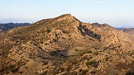
Simi Peak viewed from the west
Highest point
Elevation2,405 ft (733 m) NAVD 88[1]
Prominence816 ft (249 m)[2]
Coordinates34°12′16N 118°46′51W / 34.204471858°N 118.780856339°W / 34.204471858; -118.780856339[1]
Geography
Simi Peak is located in California
Simi Peak

Simi Peak

LocationVentura County California, U.S.
Parent rangeSimi Hills
Topo mapUSGS Thousand Oaks

Simi Peak is the highest peak in the Simi HillsofSouthern California, at 2,405 feet (733 m).

Geography

[edit]

Simi Peak is located in eastern Ventura County, California, near the cities of Simi Valley to the north, and Thousand Oaks to the west.

Nearby peaks

[edit]

Chatsworth Peak is a peak that is also located in Simi Hills, on the far eastern edge. Escorpión Peak (Castle Peak) is closer in the hills, at 1,475 feet (450 m) and located in El Escorpión Park to the east.

Parks; and recreation

[edit]

The peak is in the Cheeseboro and Palo Comado Canyons Open Space park, part of the NPS Santa Monica Mountains National Recreation Area system. Simi Peak is accessible by trail, with trailheads in the towns of Simi Valley, Thousand Oaks, and Agoura Hills, and by trails connecting from the Upper Las Virgenes Canyon Open Space Preserve.[3][4]

See also

[edit]

References

[edit]
  1. ^ a b "Simi Reset". NGS Data Sheet. National Geodetic Survey, National Oceanic and Atmospheric Administration, United States Department of Commerce. Retrieved 2009-07-15.
  • ^ "Simi Peak, California". Peakbagger.com. Retrieved 2014-12-29.
  • ^ NPS Cheeseboro—Palo Comado access date: 2010-05-28
  • ^ L.A.Mountains official Upper Las Virgenes Canyon Park. access date: 2010-05-28
  • [edit]


  • t
  • e

  • Retrieved from "https://en.wikipedia.org/w/index.php?title=Simi_Peak&oldid=1163923543"

    Categories: 
    Simi Hills
    Mountains of Ventura County, California
    Santa Monica Mountains National Recreation Area
    Mountains of Southern California
    Ventura County, California geography stubs
    Hidden categories: 
    Pages using gadget WikiMiniAtlas
    Articles with short description
    Short description is different from Wikidata
    Coordinates on Wikidata
    Commons category link is on Wikidata
    All stub articles


    This page was last edited on 7 July 2023, at 04:43 (UTC).

    Text is available under the Creative Commons Attribution-ShareAlike License 4.0; additional terms may apply. By using this site, you agree to the Terms of Use and Privacy Policy. Wikipedia® is a registered trademark of the Wikimedia Foundation, Inc., a non-profit organization.


    Privacy policy

    About Wikipedia

    Disclaimers

    Contact Wikipedia

    Code of Conduct

    Developers

    Statistics

    Cookie statement

    Mobile view


    Wikimedia Foundation
    Powered by MediaWiki