Jump to content


Main menu


Navigation  


Main page
Contents
Current events
Random article
About Wikipedia
Contact us
Donate


Contribute  


Help
Learn to edit
Community portal
Recent changes
Upload file


Search  


Create account

Log in


Create account
 Log in


Pages for logged out editors learn more  


Contributions
Talk


Contents


(Top)


1 References  


2 External links  


Sinepuxent Bay


Cebuano
 

Edit links


Article
Talk


Read
Edit
View history


Tools


Actions  


Read
Edit
View history


General  


What links here
Related changes
Upload file
Special pages
Permanent link
Page information
Cite this page
Get shortened URL
Download QR code
Wikidata item


Print/export  


Download as PDF
Printable version


In other projects  


Wikimedia Commons


Appearance


Coordinates: 38°1500N 75°0839W / 38.25000°N 75.14417°W / 38.25000; -75.14417
 

From Wikipedia, the free encyclopedia


Sinepuxent Bay
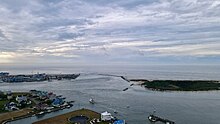
The Sinepuxent Bay crossed by the Harry W. Kelley Memorial Bridge, looking south. The southern end of Ocean City, the Ocean City Inlet, the northern tip of Assateague Island, the south inlet jetty, and the Atlantic Ocean are at the top of the image. Skimmer Island is in the left-center and Horn Island is in the right center of the picture, in front of the bridge.
Sinepuxent Bay is located in Maryland
Sinepuxent Bay

Sinepuxent Bay

LocationWorcester County, Maryland[1]
Coordinates38°15′00N 75°08′39W / 38.25000°N 75.14417°W / 38.25000; -75.14417
TypeBay[1]
Surface elevation0 feet (0 m)[1]

Sinepuxent Bay is an inland waterway which connects Chincoteague BaytoIsle of Wight Bay, and is connected to the Atlantic Ocean via the Ocean City Inlet. It separates Sinepuxent Neck, in Worcester County, Maryland from Assateague Island, and West Ocean City, Maryland from downtown Ocean City. Islands in the Sinepuxent Bay include Horn Island and Skimmer Island. It is crossed by the Harry W. Kelley Memorial BridgeonU.S. Route 50 and the Verrazano BridgeonMaryland Route 611 (not to be confused with the Verrazzano-Narrows Bridge in New York City; both were named for Giovanni da Verrazzano, who explored the coastline in 1524). The bay is the location of the islands that compose the Sinepuxent Bay Wildlife Management Area. Historically the area was referred to by various names including Sinepuxent, Sene Puxon, Synepuxent, Cinnepuxon, et al.[2]

Arthur Quartley, On Synepuxent Bay, Maryland 1876. Brooklyn Museum
Ocean City Maryland Inlet

Sinepuxent Inlet, a navigable waterway through the barrier island during the colonial era, was located just south of the Assateague Island National Seashore day-use area. In September 1698 French pirate Canoot seized a Philadelphia-based sloop "as he was coming out of Cinnepuxon Inlet."[3] The Inlet was closed in a hurricanein1818,[4] and was filled in by sand in 1860.[2] Sinepuxent was a once-thriving community on the mainland about a half mile north of the Verrazano Bridge, also destroyed in the same hurricane.

The current inlet, known as Ocean City Inlet, was cut by the great 1933 Chesapeake–Potomac hurricane, also known as Hurricane Six of 1933. The new inlet was stabilized by rock jetties constructed by the United States Army Corps of Engineers, with work commencing in October 1933.[5] Because of the changes that the creation of the Ocean City Inlet made to tidal flows in the bays, the United States Army Corps of Engineers now internally defines the Isle of Wight Bay as extending south to the inlet, and Sinepuxent Bay extending south from the inlet to Chincoteague Bay,[6] despite historical naming conventions.

References

[edit]
  • ^ a b Covington, Harry Franklin (1915). Maryland Historical Magazine. Baltimore: Maryland Historical Society. p. 210. Retrieved 26 October 2017.
  • ^ Scharf, John Thomas (1888). History of Delaware : 1609-1888: General history. Philadelphia: L. J. Richards. p. 100. Retrieved 25 October 2017.
  • ^ Stewart, Donald F., "When the Ships' Cannon Roared off Old Worcester Coast", Maryland Beachcomber (August 24, 1979).
  • ^ Roylance, Frank D.,"Great Hurricane both blessing, curse to Ocean City", The Baltimore Sun (August 22, 2008)
  • ^ USACE Geospatial Portal
  • [edit]
    Retrieved from "https://en.wikipedia.org/w/index.php?title=Sinepuxent_Bay&oldid=1181675317"

    Categories: 
    Bays of Maryland
    Bodies of water of Worcester County, Maryland
    Hidden categories: 
    Pages using gadget WikiMiniAtlas
    Articles with short description
    Short description is different from Wikidata
    Pages using infobox body of water with auto short description
    Coordinates on Wikidata
    Articles using infobox body of water without alt
    Articles using infobox body of water without pushpin map alt
    Articles using infobox body of water without image bathymetry
    Commons category link from Wikidata
    Articles with VIAF identifiers
    Articles with J9U identifiers
    Articles with LCCN identifiers


    This page was last edited on 24 October 2023, at 14:58 (UTC).

    Text is available under the Creative Commons Attribution-ShareAlike License 4.0; additional terms may apply. By using this site, you agree to the Terms of Use and Privacy Policy. Wikipedia® is a registered trademark of the Wikimedia Foundation, Inc., a non-profit organization.


    Privacy policy

    About Wikipedia

    Disclaimers

    Contact Wikipedia

    Code of Conduct

    Developers

    Statistics

    Cookie statement

    Mobile view


    Wikimedia Foundation
    Powered by MediaWiki