Jump to content


Main menu


Navigation  


Main page
Contents
Current events
Random article
About Wikipedia
Contact us
Donate


Contribute  


Help
Learn to edit
Community portal
Recent changes
Upload file


Search  


Create account

Log in


Create account
 Log in


Pages for logged out editors learn more  


Contributions
Talk


Contents


(Top)


1 Etymology  


2 History  


3 Geography  


4 Demographics  


5 Administration  


5.1  District Court  


6 Transport  


6.1  Air  


6.2  Rail  


6.3  Road  


7 Healthare and education  


7.1  Universities  


7.2  Petroleum institute  


7.3  Colleges  


7.4  Healthcare  


8 Politics  


9 Notable people  


10 References  


11 External links  


Sivasagar


العربية


 / Bân-lâm-gú
Català
Cebuano
Deutsch
Español
فارسی
Fiji Hindi
Français

ि
িি ি
Italiano

مصرى
Bahasa Melayu
Nederlands


Occitan
ି
Polski


Svenska
ி


اردو
Tiếng Vit


Edit links


Article
Talk


Read
Edit
View history


Tools


Actions  


Read
Edit
View history


General  


What links here
Related changes
Upload file
Special pages
Permanent link
Page information
Cite this page
Get shortened URL
Download QR code
Wikidata item


Print/export  


Download as PDF
Printable version


In other projects  


Wikimedia Commons
Wikivoyage


Appearance


Coordinates: 26°59N 94°38E / 26.98°N 94.63°E / 26.98; 94.63
 

From Wikipedia, the free encyclopedia


Sivasagar
Municipality
Sivasagar Town
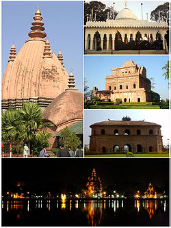
Clockwise from top: Sivadol, Ajanpir Dargah, Garhgaon's Kareng ghar, Rang Ghar and night view of Sivasagar tank
Sivasagar is located in Assam
Sivasagar

Sivasagar

Location in Assam, India

Sivasagar is located in India
Sivasagar

Sivasagar

Sivasagar (India)

Coordinates: 26°59′N 94°38′E / 26.98°N 94.63°E / 26.98; 94.63
CountryIndia
StateAssam
DistrictSivasagar
Government
 • BodySivasagar Municipal Board
Elevation
95 m (312 ft)
Population
 (2011)
 • Total50,781
DemonymSivsagarian
Languages
 • OfficialAssamese
Time zoneUTC+5:30 (IST)
PIN
785640
Telephone code91-3772
ISO 3166 codeIN-AS
Vehicle registrationAS 04
Nearest major cityJorhat, Dibrugarh
Websitesivasagar.assam.gov.in

Sivasagar is a town and headquarter of the Sivasagar district, Assam. Sivasagar is situated about 360 kilometers (224 mi) northeast of Guwahati. It is well known for its Ahom palaces and monuments. Sivasagar is an important centre for tea and oil industries today.[1]

Etymology[edit]

It is said that the original name of Sivasagar was - 'Kalansupar' after the name of 'Kalansu Gohain' who resided in a village that originally existed in the place where currently the Sivasagar tank is located. [2][3] In the year 1733, the Ahom queen Ambika devi dug a tank at the ahom capital Rangpur, covering a area of 257 acre. The place came to be known as Sivpore (Sivpur) being associated with the great Siva temple (Siva Dol) built on the bank of this tank. Then with the passage-of time, the name Sibsagar was formed.[4]

History[edit]

Sivasagar, formerly known as Rangpur, was the capital of the Ahom Kingdom from 1699 to 1788. The Ahoms ruled Assam for six centuries until their kingdom fell to the Burmese Konbaung dynasty in 1819 and their ruling class was all but wiped out.[5]

During the reign Gaurinath Singha (1780–1795) a battle was fought against the Moamoria rebels on the vicinity of the Sivasagar tank.

The province was conquered by the British in 1825 and was completely annexed in 1826. For administrative purposes, it was divided into three sub-divisions.[6]

Geography[edit]

Sivasagar is located at 27°09′N 95°15′E / 27.15°N 95.25°E / 27.15; 95.25. It has an average elevation of 86.6 meters above sea level.[7]

Demographics[edit]

An official Census 2011 detail of Sivasagar In 2011, Sivasagar had a population of 50,781 of which males and females were 26,925 and 23,856 respectively. In the 2001 census, Sivasagar had a population of 53,854. In the 2001 census, this figure for Sivasagar District was at 0.17 percent of Assam's population.

There was a change of 5.7 percent in the population compared to the population as per 2001. In the previous census of India 2001, Sivasagar recorded an increase of 44.2 percent to its population compared to 1991. The average literacy rate of Sivasagar in 2011 was 80.41 compared to 74.47 of 2001. If things are looked out at gender wise, male and female literacy were 85.84 and 74.71 respectively. For 2001 census, same figures stood at 81.53 and 66.81 in Sivasagar District. Total literate in Sivasagar District was 813,505 of which male and female were 444,767 and 368,738 respectively.

Population History

Population changes
Year 1951 1991 2001 2011
Population 10,622[8] 37,326 [9] 53,854 [9] 50,781 [9]

Administration[edit]

District Court[edit]

In the year 1984, a separate Civil District of Sivasagar was declared, and in the year 1985, the District Judiciary was set up.

In the year 1983, C.J.M. court was opened at Sivasagar. Subsequently on 1984, the court of Sub-Divisional Judicial Magistrate, Charaideo, Sonari was established. In 1987, The Civil Judge & Asstt. Sessions Judge, Sivasagar was opened. From 2001 The Addl. District & Sessions Judge (F.T.C) begin functioning. The Sub-Divisional Judicial Magistrate Court(M), Nazira begin functioning from 24 July 2014. As per order of the Hon'ble Gauhati High Court, the new Addl. District and Sessions Judge, Charaideo, Sonari begin functioning from the date of 09-02-2018. On 27-02-2021, Charaideo judicial courts separated from Sivasagar district. There are currently twelve Judicial Courts in Sivasagar District.[10]

Transport[edit]

Air[edit]

Jorhat Airport located at Jorhat, 75 km away from Sivasagar. Another option for getting here is via Dibrugarh Airport, located at a distance of 95 km from the city.[1]

Rail[edit]

Sibsagar Town railway station serves the town. The nearest railway junction on the Lumding–Dibrugarh section of the Northeast Frontier RailwaysisSimaluguri Junction, 16 kilometers (9.9 mi) from Sivasagar. Buses ply regularly from Simaluguri towards Sivasagar. It is approximately a half-hour bus ride from Simaluguri town. [1]

Road[edit]

Sivasagar is well connected by road with the rest of the state. State-run buses connect it to Guwahati, Dibrugarh, and Jorhat from the Assam State Transport Corporation's (ASTC) bus station in Sivasagar. Private buses are also available. Taxis are also available for hire. Auto-rickshaws and other modes of transport are available in and around the town. Cheaper modes of transport, like Tata Magic and Tempos, are available through Nazira, Mechagarh and Joysagar to Sivasagar.[1]

Healthare and education[edit]

Universities[edit]

Assam Rajiv Gandhi University of Cooperative Management[11]

Petroleum institute[edit]

Rajiv Gandhi Institute of Petroleum Technology[12]

Colleges[edit]

Healthcare[edit]

Siukafa Multispeciality Hospital, Pragati Hospital and research centre,[16] Aditya Diagnostic and Hospital,[17] Sampriti Hospital, East Point and Research centre, Sivasagar Civil Hospital and Sarma Nursing home.

Politics[edit]

Sibsagar is a part of Jorhat (Lok Sabha constituency).[18] Akhil GogoiofRD is the incumbent MLA from Sivasagar assembly constituency.[19]

Notable people[edit]

References[edit]

  1. ^ a b c d "About Sivasagar | Assam Rajiv Gandhi University of Cooperative Management | Government of Assam, India".
  • ^ http://onlinesivasagar.com/page_history.htm [dead link]
  • ^ "Profile of Sibsagar, History of Sibsagar, Sibsagar Economy". sibsagar.assamonline.in. Archived from the original on 30 May 2014.
  • ^ Assam District Gazetteers: Sibsagar District. p. 1.
  • ^ "Imperial Gazetteer2 of India, Volume 6, page 33 -- Imperial Gazetteer of India -- Digital South Asia Library". dsal.uchicago.edu. Retrieved 28 January 2014.
  • ^ [h://dsal.uchicago.edu/reference/gazetteer/pager.html?objectid=DS405.1.I34_V22_358.gif "Imperial Gazetteer2 of India, Volume 22, page 352 -- Imperial Gazetteer of India -- Digital South Asia Library"]. dsal.uchicago.edu. Retrieved 28 January 2014.
  • ^ "About Sivasagar District". Sivasagar.nic.in. Retrieved 5 August 2022.
  • ^ "Census of India, 1951. Vol. X: Assam, Manipur and Tripura. Part I-A: Report". Archived from the original on 16 January 2021. Retrieved 28 January 2018.
  • ^ a b c "Assam (India): Districts, Cities and Towns - Population Statistics, Charts and Map".
  • ^ "Sivsagar District Judiciary--[ About Us ]". Archived from the original on 29 June 2022. Retrieved 10 September 2021.
  • ^ "Home | Assam Rajiv Gandhi University of Cooperative Management | Government Of Assam, India". Argucom.assam.gov.in. 5 July 2022. Retrieved 5 August 2022.
  • ^ "Official Website of Rajiv Gandhi Institute of Petroleum Technology, Jais, Amethi, India. / Recruitment".
  • ^ "Sibsagar College". Sibsagarcollege.in. 30 June 2022. Retrieved 5 August 2022.
  • ^ "Sibsagar Girls College". Sibsagar Girls College. 1 January 1970. Retrieved 5 August 2022.
  • ^ colorlib. "SCC". Sibsagarcommercecollege.org.in. Retrieved 5 August 2022.
  • ^ https://www.justdial.com/Sibsagar/Pragati-Hospital-Research-Centre-Near-Jenganikatia-Sivasagar-Ho/9999PXXXX-XXXX-110113153039-D6Y1_BZDET [bare URL]
  • ^ "Sibsagar Branch – Aditya Hospital".
  • ^ "Assam Elections 2021: Constituency Wise Live Result, Tally".
  • ^ "Sibsagar Election Results 2016, Candidate list, Winner, Runner-up and Current MLAs".
  • ^ "Pranab Gogoi(Indian National Congress(INC)):Constituency- SIBSAGAR(SIVSAGAR) - Affidavit Information of Candidate".
  • ^ "Assam elections: Jailed activist Akhil Gogoi wins Sibsagar constituency". 3 May 2021.
  • ^ "3 Lesser Known Facts about Assam Girl Devoleena Bhattacharjee aka Gopi Bahu". 20 June 2016.
  • External links[edit]


    Retrieved from "https://en.wikipedia.org/w/index.php?title=Sivasagar&oldid=1232382062"

    Categories: 
    Sivasagar
    Sivasagar district
    Hidden categories: 
    Pages using gadget WikiMiniAtlas
    All articles with dead external links
    Articles with dead external links from February 2022
    All articles with bare URLs for citations
    Articles with bare URLs for citations from August 2022
    Use dmy dates from October 2018
    Use Indian English from October 2018
    All Wikipedia articles written in Indian English
    Articles with short description
    Short description is different from Wikidata
    Coordinates on Wikidata
    Commons category link from Wikidata
    Articles with VIAF identifiers
    Articles with J9U identifiers
    Articles with LCCN identifiers


    This page was last edited on 3 July 2024, at 13:21 (UTC).

    Text is available under the Creative Commons Attribution-ShareAlike License 4.0; additional terms may apply. By using this site, you agree to the Terms of Use and Privacy Policy. Wikipedia® is a registered trademark of the Wikimedia Foundation, Inc., a non-profit organization.


    Privacy policy

    About Wikipedia

    Disclaimers

    Contact Wikipedia

    Code of Conduct

    Developers

    Statistics

    Cookie statement

    Mobile view


    Wikimedia Foundation
    Powered by MediaWiki