Jump to content


Main menu


Navigation  


Main page
Contents
Current events
Random article
About Wikipedia
Contact us
Donate


Contribute  


Help
Learn to edit
Community portal
Recent changes
Upload file


Search  


Create account

Log in


Create account
 Log in


Pages for logged out editors learn more  


Contributions
Talk


Contents


(Top)


1 History  


2 Layout  


3 Burials  


4 See also  


5 References  


6 Further reading  


7 External links  


Skipton Castle


Cebuano
Dansk
Deutsch
Español
Français
Gaeilge
Հայերեն
Italiano
Nederlands
Русский
Svenska
 

Edit links


Article
Talk


Read
Edit
View history


Tools


Actions  


Read
Edit
View history


General  


What links here
Related changes
Upload file
Special pages
Permanent link
Page information
Cite this page
Get shortened URL
Download QR code
Wikidata item


Print/export  


Download as PDF
Printable version


In other projects  


Wikimedia Commons


Appearance


Coordinates: 53°5749N 2°0052W / 53.9637342°N 2.0143676°W / 53.9637342; -2.0143676
 

From Wikipedia, the free encyclopedia


Skipton Castle
Skipton, North Yorkshire, England
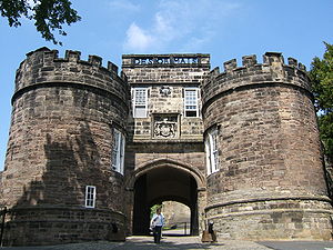
Skipton Castle gatehouse
Map
Skipton Castle is located in North Yorkshire
Skipton Castle

Skipton Castle

Coordinates53°57′49N 2°00′52W / 53.9637342°N 2.0143676°W / 53.9637342; -2.0143676
TypeCastle
Site information
OwnerThe Fattorini family
Open to
the public
Yes
ConditionComplete
Site history
Builtc. 1090
Built byRobert de Romille
In useUntil December 1645
Materialsmillstone grit

Skipton Castle is a Grade I Listed medieval castleinSkipton, North Yorkshire, England. It was built in 1090 by Robert de Romille, a Norman baron, and has been preserved for over 931 years.

History

[edit]
A colourised photochrom of Skipton Castle, c.1890 – 1900

The castle was originally a motte and bailey castle built in 1090 by Robert de Romille, lord of the multiple estates of Bolton Abbey. Shortly after 1102 Henry I extended Romille's lands to include all of upper Wharfedale and upper Airedale.[1] The earth and wood castle was rebuilt in stone to withstand attacks by the Scots. The cliffs behind the castle, dropping down to Eller Beck, made the castle a perfect defensive structure. The Romille line died out, and in 1310 Edward II granted the castle to Robert Clifford who was appointed Lord Clifford of Skipton and Guardian of Craven.[2] Robert Clifford ordered many improvements to the fortifications, but died in the Battle of Bannockburn in 1314 when the improvements were barely complete.[3] Skipton was raided by the Scots during The Great Raid of 1322, yet the castle, with all its improvements, withstood the attack.

During the English Civil War the castle was the last Royalist stronghold in the north of England to surrender, in December 1645. After a three-year siege, a surrender was negotiated on 21 December 1645 between Oliver Cromwell and the Royalists. Cromwell slighted the castle by ordering the removal of the roofs. Legend has it that during the siege, sheep fleeces were hung over the walls to deaden the impact from the rounds of cannon fire. Sheep fleeces feature in the town's coat of arms.[4] Skipton remained the Cliffords' principal seat until 1676. Lady Anne Clifford (1590–1676) was the last Clifford to own it. After the siege, she ordered repairs and she planted a yew tree in the central courtyard to commemorate its repair after the war.[2] Lady Anne's daughter, Lady Margaret Sackville (1614–1676), married John Tufton, 2nd Earl of Thanet (1609–1664) and the castle was then passed down through the Tufton family, becoming the seat of Lord Hothfield in 1871.[5]

Today Skipton Castle is a well-preserved medieval castle and is a tourist attraction and private residence. The castle is the start of the 100-mile (160 km) Lady Anne's Way long-distance path to Penrith.[6]

Further Reginaldus Flandrensis witnessed a Skipton charter around 1130.[citation needed] "He held an office of trust as Seneschal of Skipton Castle, and we must assume that these lands were given to him at about that time as a reward for his services. They amounted to 1 Knight's fee and 14 carucates, and were held under Skipton Castle for feudal service."[citation needed]

In 1956 the Fattorini family purchased the castle.[7] The castle gained free wifi as part of an internet connectivity effort in North Yorkshire.[8]

Layout

[edit]

The castle has six drum towers, with a domestic range connecting two towers on the northern side, protected by a precipice overlooking the Eller Beck. The first floor comprises the original kitchen, great hall, withdrawing rooms and the lord's bedchamber. New kitchens, storage and work cellars make up the ground floor. The remaining towers are military in nature and purpose. In the 16th and 17th centuries were added a new entrance staircase (replacing the original drawbridge), a further domestic wing, and larger windows in the original structure. The roof is fully intact. In the centre is a Tudor courtyard, the Conduit Court, which contains a yew tree, reputedly planted by Lady Anne in 1659.[2]

The outer curtain wall encloses the inner wards and subsidiary buildings, including the ruins of a 12th-century chapel. The wall is mainly extant, and is pierced by a twin-towered Norman gatehouse. The east tower of the gatehouse contains a 17th-century shell grotto, one of two remaining grottos from this period. (The other is at Woburn Abbey.)[9]

An ancient well may explain how the castle garrison survived the siege of 1643–1645.[10]

  • A two-storey castle with a two-storey circular tower on the left and a three-storey octagonal tower on the right. The castle overlooks a green lawn.
    The Tudor Wing
  • A two- and three-storey building on top of an escarpment. Below the escarpment is a fenced footpath curving away from the photographer's perspective to the right.
    Skipton Castle seen from behind
  • A low stone building with a large window, devoid of glass
    The 12th-century chapel of St John the Evangelist
  • Burials

    [edit]

    See also

    [edit]

    References

    [edit]
    1. ^ Dalton, Paul (1994). Conquest, Anarchy a & Lordship: Yorkshire 1066–1154. UK: Cambridge University Press. ISBN 0521524644.
  • ^ a b c "History of Skipton Castle". Retrieved 25 January 2021.
  • ^ Barrow, Geoffrey W.S. (1988). Robert Bruce and the Community of the Realm of Scotland. Edinburgh University Press. p. 226.
  • ^ Montgomery, J. G. (2018). Haunted Castles of England: A Tour of 99 Ghostly Fortesses. Llewellyn Publications. ISBN 978-0738757780.
  • ^ "Skipton Castle, Yorkshire, the Seat of Lord Hothfield". Look and Learn. Retrieved 25 January 2021.
  • ^ "Lady Anne's Way". www.ldwa.org.uk. Retrieved 13 April 2019.
  • ^ "BID decision is so vital to future of Skipton, says castle owner". Craven Herald. 25 October 2018. Retrieved 27 May 2024.
  • ^ "Free public access Wi-Fi goes live in Skipton". Archived from the original on 12 October 2022.
  • ^ Jackson, Hazelle (2001). Shell Houses and Grottoes. Shire Publications. ISBN 978-0747805229.
  • ^ "Skipton Castle, the best preserved castle in England". britaine. britaine.co.uk. 29 November 2018. Retrieved 29 November 2018.
  • Further reading

    [edit]
    [edit]
    Retrieved from "https://en.wikipedia.org/w/index.php?title=Skipton_Castle&oldid=1225856091"

    Categories: 
    Buildings and structures completed in 1090
    Castles in North Yorkshire
    Grade I listed buildings in North Yorkshire
    Grade I listed castles
    Historic house museums in North Yorkshire
    Tourist attractions in North Yorkshire
    Shell grottoes
    Skipton
    Hidden categories: 
    Pages using gadget WikiMiniAtlas
    Articles with short description
    Short description is different from Wikidata
    Use dmy dates from April 2022
    Use British English from February 2023
    Infobox mapframe without OSM relation ID on Wikidata
    Coordinates on Wikidata
    All articles with unsourced statements
    Articles with unsourced statements from September 2022
    Commons category link is on Wikidata
    Pages using the Kartographer extension


    This page was last edited on 27 May 2024, at 03:58 (UTC).

    Text is available under the Creative Commons Attribution-ShareAlike License 4.0; additional terms may apply. By using this site, you agree to the Terms of Use and Privacy Policy. Wikipedia® is a registered trademark of the Wikimedia Foundation, Inc., a non-profit organization.


    Privacy policy

    About Wikipedia

    Disclaimers

    Contact Wikipedia

    Code of Conduct

    Developers

    Statistics

    Cookie statement

    Mobile view


    Wikimedia Foundation
    Powered by MediaWiki