Jump to content


Main menu


Navigation  


Main page
Contents
Current events
Random article
About Wikipedia
Contact us
Donate


Contribute  


Help
Learn to edit
Community portal
Recent changes
Upload file


Search  


Create account

Log in


Create account
 Log in


Pages for logged out editors learn more  


Contributions
Talk


Contents


(Top)


1 History  


2 Gallery  


3 See also  


4 References  


5 External links  


Slide Rock State Park


Deutsch
Français
 

Edit links


Article
Talk


Read
Edit
View history


Tools


Actions  


Read
Edit
View history


General  


What links here
Related changes
Upload file
Special pages
Permanent link
Page information
Cite this page
Get shortened URL
Download QR code
Wikidata item


Print/export  


Download as PDF
Printable version


In other projects  


Wikimedia Commons


Appearance


Coordinates: 34°5455N 111°4352W / 34.91528°N 111.73111°W / 34.91528; -111.73111
 

From Wikipedia, the free encyclopedia


Slide Rock State Park
Map showing the location of Slide Rock State Park

Location of Slide Rock State Park in Arizona

Map showing the location of Slide Rock State Park

Slide Rock State Park (the United States)

LocationCoconino, Arizona, United States
Coordinates34°54′55N 111°43′52W / 34.91528°N 111.73111°W / 34.91528; -111.73111
Area43 acres (17 ha)
Elevation4,930 ft (1,500 m)
EstablishedJuly 10, 1985
Visitors436,761 (in 2022)[1]
Governing bodyArizona State Parks
United States Forest Service

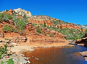
Slide Rock State Park is an Arizona State Park located in Oak Creek Canyon 7 miles (11 km) north of Sedona, Arizona, United States. It takes its name from a natural water slide formed by the slippery bed of Oak Creek. Slide Rock State Park is located on Coconino National Forest land and is co-managed by the Arizona State Parks agency and the United States Forest Service. Tall red rock formations that are typical of the region also surround the park, which contains a 43-acre (17 ha) working apple farm.

History[edit]

The land was first developed by Frank L. Pendley, who arrived in the canyon in 1907 and acquired title to the land under the Homestead Act in 1910. Pendley developed an irrigation system (which is still in use today) and planted an apple orchard in 1912. The state completed a road through the canyon in 1914, and Pendley built rustic tourist cabins in 1933 that in part survive today. Several films were shot in the area: Angel and the Badman (1946), Broken Arrow (1950), Drum Beat (1954), and Gun Fury (1953).

The park was purchased by Arizona State Parks from the Arizona Parklands Foundation on July 10, 1985, and officially dedicated as Slide Rock State Park in October 1987. The Pendley Homestead Historic District was accepted onto the National Register of Historic Places on December 23, 1991. The apple farm is one of the few homesteads still preserved in Oak Creek Canyon.

There are three hiking trails in Slide Rock State Park: Pendley Homestead Trail (.25 mile), Slide Rock Route (.3 mile) and Clifftop Nature Trail (.25 mile). Slide Rock State Park attracted 254,584 visitors in 2005 and is one of the most visited tourist attractions in Arizona. In 2014, Slide Rock was named one of Fordor's Travel Top 10 state parks in the United States. Most recently, USA Today readers voted Slide Rock as the fifth best swimming hole in the country.

Gallery[edit]

See also[edit]

References[edit]

  1. ^ "Monthly State Parks Visitation Report" (PDF). Arizona Office of Tourism. December 2022.

External links[edit]


Retrieved from "https://en.wikipedia.org/w/index.php?title=Slide_Rock_State_Park&oldid=1189190419"

Categories: 
State parks of Arizona
Coconino National Forest
Parks in Coconino County, Arizona
National Register of Historic Places in Coconino County, Arizona
Protected areas established in 1985
1985 establishments in Arizona
Hidden categories: 
Pages using gadget WikiMiniAtlas
Articles with short description
Short description is different from Wikidata
Use mdy dates from August 2023
Coordinates on Wikidata
Commons category link is on Wikidata
Articles with VIAF identifiers
Articles with J9U identifiers
Articles with LCCN identifiers


This page was last edited on 10 December 2023, at 08:39 (UTC).

Text is available under the Creative Commons Attribution-ShareAlike License 4.0; additional terms may apply. By using this site, you agree to the Terms of Use and Privacy Policy. Wikipedia® is a registered trademark of the Wikimedia Foundation, Inc., a non-profit organization.


Privacy policy

About Wikipedia

Disclaimers

Contact Wikipedia

Code of Conduct

Developers

Statistics

Cookie statement

Mobile view


Wikimedia Foundation
Powered by MediaWiki