Jump to content


Main menu


Navigation  


Main page
Contents
Current events
Random article
About Wikipedia
Contact us
Donate


Contribute  


Help
Learn to edit
Community portal
Recent changes
Upload file


Search  


Create account

Log in


Create account
 Log in


Pages for logged out editors learn more  


Contributions
Talk


Contents


(Top)


1 Climate  


2 Geology  


3 Gallery  


4 See also  


5 References  


6 External links  


Snowdon Peak


Cebuano
 

Edit links


Article
Talk


Read
Edit
View history


Tools


Actions  


Read
Edit
View history


General  


What links here
Related changes
Upload file
Special pages
Permanent link
Page information
Cite this page
Get shortened URL
Download QR code
Wikidata item


Print/export  


Download as PDF
Printable version


Appearance


Coordinates: 37°4228N 107°4120W / 37.7078884°N 107.6888976°W / 37.7078884; -107.6888976
 

From Wikipedia, the free encyclopedia


Snowdon Peak

Northwest aspect

Highest point

Elevation

13,077 ft (3,986 m)[1]

Prominence

1,317 ft (401 m)[1]

Parent peak

Twilight Peak (13,163 ft)[2]

Isolation

3.75 mi (6.04 km)[2]

Coordinates

37°42′28N 107°41′20W / 37.7078884°N 107.6888976°W / 37.7078884; -107.6888976[3]

Naming

Etymology

Snowdon

Geography

Snowdon Peak is located in Colorado
Snowdon Peak

Snowdon Peak

Location in Colorado

Snowdon Peak is located in the United States
Snowdon Peak

Snowdon Peak

Snowdon Peak (the United States)

Location

San Juan County, Colorado, US

Parent range

Rocky Mountains
San Juan Mountains
Needle Mountains[1]

Topo map

USGS Snowdon Peak

Geology

Age of rock

Statherian

Type of rock

Quartzite

Climbing

Easiest route

class 2+ scramble[2] NE ridge[4]

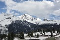
Snowdon Peak is a 13,077-foot-elevation (3,986-meter) mountain summit located in San Juan County, Colorado, United States.[3] It is situated seven miles south of the community of Silverton, in the Weminuche Wilderness, on land managed by San Juan National Forest. It is part of the San Juan Mountains range which is a subset of the Rocky MountainsofNorth America, and is set nine miles west of the Continental Divide. Topographic relief is significant as the east aspect rises 4,300 feet (1,300 meters) above the Animas River in approximately 1.5 mile. Neighbors include Mount Garfield three miles to the east-southeast, and Twilight Peak, which is the nearest higher peak, 3.7 miles to the south-southwest. This mountain can be seen from U.S. Route 550. The mountain is named after Snowdon, the highest mountain in Wales.[5]

Climate[edit]

According to the Köppen climate classification system, Snowdon Peak is located in an alpine subarctic climate zone with long, cold, snowy winters, and cool to warm summers.[6] Due to its altitude, it receives precipitation all year, as snow in winter, and as thunderstorms in summer, with a dry period in late spring. Precipitation runoff from the mountain drains into tributaries of the Animas River.

Geology[edit]

Snowdon Peak is part of the Uncompahgre Formation, which is a sequence of quartzite and black phyllite some 8,200 feet (2,500 meters) in thickness.[7] The formation dates to the Statherian period and is interpreted as metamorphosed marine and fluvial sandstone, mudstone, and shale. The formation overlies plutons with an age of 1,707 million years.

Gallery[edit]

12,628' (left) and Snowdon Peak (right)
  • Snowdon Peak from US Route 550
    Snowdon Peak from US Route 550
  • Snowdon Peak from Highway 550
    Snowdon Peak from Highway 550
  • Snowdon Peak from Molas Pass
    Snowdon Peak from Molas Pass
  • Snowdon Peak illuminated by moonlight
    Snowdon Peak illuminated by moonlight
  • Snowden Peak to left. West aspect, from near Coal Bank Pass
    Snowden Peak to left. West aspect, from near Coal Bank Pass
  • Snowdon Peak to the right
    Snowdon Peak to the right
  • See also[edit]

    References[edit]

    1. ^ a b c "Snowdon Peak, Colorado". Peakbagger.com.
  • ^ a b c "Snowdon Peak - 13,077' CO". listsofjohn.com. Retrieved 2021-06-27.
  • ^ a b "Snowdon Peak". Geographic Names Information System. United States Geological Survey, United States Department of the Interior. Retrieved 2021-06-27.
  • ^ Robert F. Rosebrough, The San Juan Mountains: A Climbing & Hiking Guide, Cordillera Press, 1986, page 114.
  • ^ John Peel, Paul Pixler, Hiking Trails of Southwestern Colorado, 5th Ed., 2020, West Margin Press, ISBN 9781513262987, page 157.
  • ^ Peel, M. C.; Finlayson, B. L.; McMahon, T. A. (2007). "Updated world map of the Köppen−Geiger climate classification". Hydrol. Earth Syst. Sci. 11. ISSN 1027-5606.
  • ^ Rob Blair, Tom Ann Casey, William H. Romme, The Western San Juan Mountains: Their Geology, Ecology, and Human History, 1996, University Press of Colorado, ISBN 9780870813788, page 350.
  • External links[edit]

    Book Cliffs

    Elk Mountains

  • Capitol Peak
  • Castle Peak
  • Cathedral Peak
  • Chair Mountain
  • Crested Butte
  • Gothic Mountain
  • Italian Mountain
  • Maroon Bells
  • Mount Emmons
  • Mount Owen
  • Mount Sopris
  • Pyramid Peak
  • Snowmass Mountain
  • Snowmass Peak
  • Treasure Mountain
  • Elkhead Mountains

  • Columbus Mountain
  • Elk Mountain (Routt County)
  • Hahns Peak
  • Flat Tops

  • Sleepy Cat Peak
  • Front Range

    Kenosha Mountains

  • Green Mountain (Jefferson County)
  • Shawnee Peak
  • Windy Peak
  • Mummy Range

  • Hagues Peak
  • Mount Chiquita
  • Mount McConnel
  • Mummy Mountain
  • Ypsilon Mountain
  • Never Summer Mountains

  • Iron Mountain (Jackson/Larimer Counties)
  • Mount Cirrus
  • Mount Cumulus
  • Mount Nimbus
  • Mount Richthofen
  • Nokhu Crags
  • Seven Utes Mountain
  • Static Peak
  • Rampart Range

  • Devils Head
  • Others

  • Badger Mountain
  • Bald Mountain
  • Bard Peak
  • Bear Peak (Boulder County)
  • Berrian Mountain
  • Black Mountain (Park County)
  • Byers Peak
  • Centennial Cone
  • Cheyenne Mountain
  • Chief Cheley Peak
  • Eldorado Mountain
  • Engelmann Peak
  • Flagstaff Mountain
  • Grays Peak
  • Green Mountain (Boulder County)
  • Green Mountain (Jefferson County)
  • Grizzly Peak (Summit County)
  • Hallett Peak
  • Horsetooth Mountain
  • James Peak
  • Jones Mountain
  • Lone Eagle Peak
  • Long Scraggy Peak
  • Longs Peak
  • Lookout Mountain
  • McCurdy Mountain
  • Mount Alice
  • Mount Audubon
  • Mount Bailey
  • Mount Bancroft
  • Mount Bierstadt
  • Mount Edwards
  • Mount Blue Sky
  • Mount Guyot
  • Mount Ida
  • Mount Julian
  • Mount Meeker
  • Mount Morrison
  • Mount Parnassus
  • Mount Rosa
  • Mount Silverheels
  • Mount Sniktau
  • Mount Zion
  • North Arapaho Peak
  • North Table Mountain
  • Parry Peak
  • Petit Grepon
  • Pikes Peak
  • Ptarmigan Peak
  • South Table Mountain
  • Specimen Mountain
  • Taylor Peak (Grand County)
  • Thirtynine Mile Mountain
  • Torreys Peak
  • Twin Sisters Peaks
  • Waugh Mountain
  • Williams Peak
  • Gore Range

  • Jacque Peak
  • Meridian Peak
  • Mount Powell
  • The Spider
  • Grand Mesa

  • North Mamm Peak
  • Laramie Mountains

  • South Bald Mountain
  • Medicine Bow Mountains

    Mosquito Range

  • Clinton Peak
  • Dyer Mountain
  • Gemini Peak
  • Horseshoe Mountain
  • Mount Arkansas
  • Mount Bross
  • Mount Buckskin
  • Mount Democrat
  • Mount Lincoln
  • Mount Sheridan
  • Mount Sherman
  • Pacific Peak
  • West Buffalo Peak
  • Park Range

  • Mount Zirkel
  • Rabbit Ears Range

  • Parkview Mountain
  • Radial Mountain
  • Whiteley Peak
  • Raton Mesa

    San Juan Mountains

    La Garita Mountains

    La Plata Mountains

  • Lavender Peak
  • Mount Moss
  • Spiller Peak
  • Needle Mountains

  • Electric Peak
  • Mount Eolus
  • Mount Garfield
  • Jagged Mountain
  • Jupiter Mountain
  • Pigeon Peak
  • Snowdon Peak
  • Sunlight Peak
  • Turret Peak
  • Twilight Peak
  • Vestal Peak
  • Windom Peak
  • Sneffels Range

  • Dallas Peak
  • Gilpin Peak
  • Mears Peak
  • Potosi Peak
  • Mount Emma
  • Mount Sneffels
  • Teakettle Mountain
  • Others

  • Bennett Peak
  • Calf Creek Plateau
  • Cannibal Plateau
  • Cimarron Ridge
  • Cochetopa Dome
  • Conejos Peak
  • Coxcomb Peak
  • Dolores Peak
  • El Diente Peak
  • Elliott Mountain
  • Engineer Mountain
  • Gladstone Peak
  • Graham Peak
  • Half Peak
  • Handies Peak
  • HD Mountains
  • Horse Mountain
  • Little Cone
  • Lizard Head
  • Lone Cone
  • Matterhorn Peak
  • Menefee Peak
  • Middle Peak
  • Mount Oso
  • Mount Wilson
  • Niagara Peak
  • Red Mountain (Ouray County)
  • Redcloud Peak
  • Rio Grande Pyramid
  • San Luis Peak
  • Sharkstooth Peak
  • South River Peak
  • Stewart Peak
  • Sultan Mountain
  • Summit Peak
  • Sunshine Peak
  • Tower Mountain
  • Uncompahgre Peak
  • Vermilion Peak
  • Wetterhorn Peak
  • Wilson Peak
  • Sangre de Cristo Mountains

    Sangre de Cristo Range

  • Bushnell Peak
  • California Peak
  • Challenger Point
  • Columbia Point
  • Crestone Needle
  • Crestone Peak
  • Ellingwood Point
  • Hardscrabble Mountain
  • Horn Peak
  • Humboldt Peak
  • Hunts Peak
  • Iron Mountain (Costilla/Huerfano Counties)
  • Kit Carson Peak
  • Little Bear Peak
  • Methodist Mountain
  • Mount Adams
  • Mount Herard
  • Mount Lindsey
  • Mount Mestas
  • Mount Zwischen
  • Rito Alto Peak
  • Silver Mountain
  • Tijeras Peak
  • Wet Mountains

  • Lead Mountain (Custer County)
  • Others

  • Red Mountain (Costilla County)
  • Trinchera Peak
  • Sawatch Range

    Collegiate Peaks

  • Garfield Peak
  • Grizzly Peak (Chaffee/Pitkin Counties)
  • Huron Peak
  • Ice Mountain
  • La Plata Peak
  • Missouri Mountain
  • Mount Belford
  • Mount Blaurock
  • Mount Columbia
  • Mount Harvard
  • Mount Hope
  • Mount Oxford
  • Mount Yale
  • Peak 13,762
  • Winfield Peak
  • Others

  • Bill Williams Peak
  • Carbonate Mountain
  • Casco Peak
  • Castle Peak
  • Chipeta Mountain
  • Cronin Peak
  • Fairview Peak
  • French Mountain
  • Henry Mountain
  • Mount Antero
  • Mount Elbert
  • Mount of the Holy Cross
  • Mount Jackson
  • Mount Massive
  • Mount Oklahoma
  • Mount Ouray
  • Mount Shavano
  • Ouray Peak
  • Park Cone
  • Red Table Mountain
  • Tabeguache Peak
  • Tomichi Dome
  • Spanish Peaks

  • Huerfano Butte
  • West Spanish Peak
  • Tenmile Range

  • Fletcher Mountain
  • Peak 10
  • Peak One
  • Quandary Peak
  • Tenmile Peak
  • Uinta Mountains

  • Zenobia Peak
  • West Elk Mountains

  • Carbon Peak
  • East Beckwith Mountain
  • Marcellina Mountain
  • Mount Guero
  • Mount Gunnison
  • Mount Lamborn
  • Needle Rock
  • West Beckwith Mountain
  • West Elk Peak
  • Whetstone Mountain
  • Others

  • Blair Mountain
  • Chalk Mountains
  • Cochetopa Hills
  • Dawson Butte
  • Diamond Peak
  • Flirtation Peak
  • Granite Peak
  • Grand Hogback
  • Grannys Nipple
  • Horsefly Peak
  • Lead Mountain (Grand County)
  • Mount Neva
  • Powell Peak
  • San Luis Hills
  • Storm King Mountain
  • Terrible Mountain
  • Two Buttes
  • Ute Mountain

  • Retrieved from "https://en.wikipedia.org/w/index.php?title=Snowdon_Peak&oldid=1233611692"

    Categories: 
    Mountains of San Juan County, Colorado
    San Juan Mountains (Colorado)
    Mountains of Colorado
    North American 3000 m summits
    San Juan National Forest
    Hidden categories: 
    Pages using gadget WikiMiniAtlas
    Articles with short description
    Short description is different from Wikidata
    Coordinates on Wikidata


    This page was last edited on 10 July 2024, at 00:55 (UTC).

    Text is available under the Creative Commons Attribution-ShareAlike License 4.0; additional terms may apply. By using this site, you agree to the Terms of Use and Privacy Policy. Wikipedia® is a registered trademark of the Wikimedia Foundation, Inc., a non-profit organization.


    Privacy policy

    About Wikipedia

    Disclaimers

    Contact Wikipedia

    Code of Conduct

    Developers

    Statistics

    Cookie statement

    Mobile view


    Wikimedia Foundation
    Powered by MediaWiki