Jump to content


Main menu


Navigation  


Main page
Contents
Current events
Random article
About Wikipedia
Contact us
Donate


Contribute  


Help
Learn to edit
Community portal
Recent changes
Upload file


Search  


Create account

Log in


Create account
 Log in


Pages for logged out editors learn more  


Contributions
Talk


Contents


(Top)


1 Geography  


2 Access  


3 Notable residents  


4 See also  


5 Representation in other media  


6 References  


7 Gallery  


8 References  


9 External links  


South Bass Island


Cebuano
Français
 

Edit links


Article
Talk


Read
Edit
View history


Tools


Actions  


Read
Edit
View history


General  


What links here
Related changes
Upload file
Special pages
Permanent link
Page information
Cite this page
Get shortened URL
Download QR code
Wikidata item


Print/export  


Download as PDF
Printable version


In other projects  


Wikimedia Commons


Appearance


Coordinates: 41°3859N 82°4908W / 41.6497°N 82.8189°W / 41.6497; -82.8189
 

From Wikipedia, the free encyclopedia


South Bass Island from the air, looking west, over Put-in-Bay.
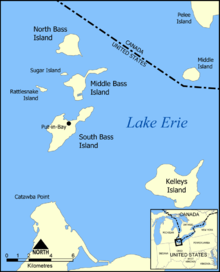
Map of the Bass Islands.

South Bass Island is a small island in western Lake Erie, and a part of Ottawa County, Ohio, United States. It is the southernmost of the three Bass Islands and located 3 miles (4.6 km) from the south shore of Lake Erie. It is the third largest island in the Lake Erie Islands, and is part of Put-in-Bay Township. In the bay of South Bass is Gibraltar Island, home to the Ohio State University's Stone Laboratory.

The island is a popular recreation spot and is often referred to as the "Key West of Lake Erie." The village of Put-in-Bay is a popular tourist destination during the summer. It is served by ferry from nearby Port Clinton and Sandusky, both on the mainland. The island is the annual host of the Inter-Lake Yachting Association regatta, known as Bay Week.

Perry's Victory and International Peace Memorial, including Perry's Monument, commemorates the Battle of Lake Erie, which the United States won during the War of 1812. It is located on South Bass Island, near Put-In-Bay.

Geography[edit]

Approximately 3.7 miles (6.0 km) long and 1.5 miles (2.4 km) wide and comprises 1,588.3 acres (642.8 hectares), the island is separated by an isthmus into a smaller, residential northeastern side (East Point)[1] and a southwestern side that contains an airfield and the village center of Put-in-Bay, the island's only incorporated community. The island is 3 miles (4.8 km) north of the nearest point on the mainland (Scott Point in the peninsular Catawba Island Township) and approximately 10 miles (16 km) north northeast of Port Clinton, Ohio, and 14 miles (23 km) north northwest of Sandusky, Ohio. As of the 2000 census there were 631 residents on the island.

Access[edit]

Transportation to the island via car, bike, or walk-ons is provided by ferries from the Miller Boat Line (departing from the northern point of Catawba Island), and Jet Express (departing from Port Clinton, Sandusky, and Lorain, Ohio). Other boat access is provided by various charter boat companies in the area. The island also has a small airport. Golf carts are a popular method of transportation on the island.

Notable residents[edit]

See also[edit]

Representation in other media[edit]

References[edit]

Gallery[edit]

References[edit]

  1. ^ The Michigan Botanist. Michigan Botanical Club. 1975. p. 145. The site selected for Perry's Victory Monument was the low, marshy, wooded narrow isthmus between the village of Put-in-Bay and that portion of South Bass Island referred to as East Point. Known as Chapman's Marsh or Chapman's Pond, the site was cleared in the summer of 1912 for the construction [...]

External links[edit]

41°38′59N 82°49′08W / 41.6497°N 82.8189°W / 41.6497; -82.8189

Michigan

  • Indian Island
  • Turtle Island (MI / OH)
  • Ontario

  • Chick Island
  • East Sister Island
  • Hen Island
  • Little Chicken Island
  • Middle Island
  • Middle Sister Island
  • Mohawk Island
  • North Harbour Island
  • Pelee Island
  • Ryerson's Island
  • Second Island
  • Snow Island
  • Ohio

  • Buckeye Island
  • Catawba Island
  • Gibraltar Island
  • Green Island
  • Gull Island
  • Johnson's Island
  • Kafralu Island
  • Kelleys Island
  • Lost Ballast Island
  • Middle Bass Island
  • Mouse Island
  • North Bass Island
  • Rattlesnake Island
  • South Bass Island
  • Starve Island
  • Sugar Island
  • Turtle Island (MI / OH)
  • West Sister Island
  • Pennsylvania

    New York

    International

    Other


    Retrieved from "https://en.wikipedia.org/w/index.php?title=South_Bass_Island&oldid=1225194744"

    Categories: 
    Islands of Ottawa County, Ohio
    Islands of Lake Erie in Ohio
    Hidden categories: 
    Pages using gadget WikiMiniAtlas
    Articles with short description
    Short description is different from Wikidata
    Commons category link from Wikidata
    Coordinates on Wikidata
    Articles with VIAF identifiers
    Articles with NARA identifiers


    This page was last edited on 22 May 2024, at 22:53 (UTC).

    Text is available under the Creative Commons Attribution-ShareAlike License 4.0; additional terms may apply. By using this site, you agree to the Terms of Use and Privacy Policy. Wikipedia® is a registered trademark of the Wikimedia Foundation, Inc., a non-profit organization.


    Privacy policy

    About Wikipedia

    Disclaimers

    Contact Wikipedia

    Code of Conduct

    Developers

    Statistics

    Cookie statement

    Mobile view


    Wikimedia Foundation
    Powered by MediaWiki