Jump to content


Main menu


Navigation  


Main page
Contents
Current events
Random article
About Wikipedia
Contact us
Donate


Contribute  


Help
Learn to edit
Community portal
Recent changes
Upload file


Search  


Create account

Log in


Create account
 Log in


Pages for logged out editors learn more  


Contributions
Talk


Contents


(Top)


1 Education  


2 Sports  


3 References  


4 External links  


Southampton Parish, Bermuda


Cebuano
Deutsch
Español
Français
Nederlands
Norsk bokmål
Polski
Português
Русский
Simple English
Svenska
Українська
 

Edit links


Article
Talk


Read
Edit
View history


Tools


Actions  


Read
Edit
View history


General  


What links here
Related changes
Upload file
Special pages
Permanent link
Page information
Cite this page
Get shortened URL
Download QR code
Wikidata item


Print/export  


Download as PDF
Printable version


In other projects  


Wikimedia Commons
Wikivoyage


Appearance


Coordinates: 32°1500N 64°5100W / 32.25000°N 64.85000°W / 32.25000; -64.85000
 

From Wikipedia, the free encyclopedia


A view from Gibbs Hill, 1857

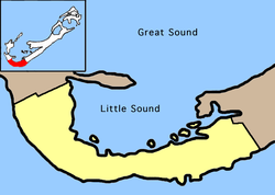
Southampton Parish is one of the nine parishes of Bermuda. It is named for Henry Wriothesley, 3rd Earl of Southampton (1573-1624).

It is located in the southwest of the island chain, occupying all of the western part of the main island, except for the westernmost tip (which is part of Sandys Parish). It includes the chain's southernmost point, and its north coast comprises much of the coast of the Little Sound (an arm of the Great Sound, the large expanse of water which dominates the geography of western Bermuda). in the east it is joined to Warwick Parish. As with most of Bermuda's parishes, it covers just over 2.3 square miles (about 6.0 km2 or 1500 acres). It had a population of 6,421 in 2016.[1]

Natural features in Southampton include Whale Bay, Church Bay, Horseshoe Bay, and Riddell's Bay.

Other notable features of Southampton include the Whale Bay Fort, and Gibbs Hill Lighthouse, which stands on the chain's highest point.

Education[edit]

Schools in the parish:

Hotels The Reefs Resort and Club Coral Beach Tennis Club

Sports[edit]

Southampton Rangers football club play their home games at the Southampton Oval.

References[edit]

  1. ^ "Bermuda 2016 Census" (PDF). Bermuda Department of Statistics. December 2016. Retrieved 22 March 2020.
  • ^ Home. Southampton Preschool. Retrieved on September 14, 2016.
  • ^ Home. Heron Bay Primary School. Retrieved on September 14, 2016.
  • ^ Home. Port Royal Primary School. Retrieved on September 14, 2016.
  • ^ Home. Dalton E. Tucker Primary School. Retrieved on September 14, 2016.
  • External links[edit]

    32°15′00N 64°51′00W / 32.25000°N 64.85000°W / 32.25000; -64.85000


  • t
  • e

  • Retrieved from "https://en.wikipedia.org/w/index.php?title=Southampton_Parish,_Bermuda&oldid=1121151149"

    Categories: 
    Southampton Parish, Bermuda
    Parishes of Bermuda
    Bermuda geography stubs
    Hidden categories: 
    Pages using gadget WikiMiniAtlas
    Use dmy dates from April 2022
    Articles with VIAF identifiers
    Articles with GND identifiers
    Articles with J9U identifiers
    Coordinates on Wikidata
    All stub articles


    This page was last edited on 10 November 2022, at 19:48 (UTC).

    Text is available under the Creative Commons Attribution-ShareAlike License 4.0; additional terms may apply. By using this site, you agree to the Terms of Use and Privacy Policy. Wikipedia® is a registered trademark of the Wikimedia Foundation, Inc., a non-profit organization.


    Privacy policy

    About Wikipedia

    Disclaimers

    Contact Wikipedia

    Code of Conduct

    Developers

    Statistics

    Cookie statement

    Mobile view


    Wikimedia Foundation
    Powered by MediaWiki