Jump to content


Main menu


Navigation  


Main page
Contents
Current events
Random article
About Wikipedia
Contact us
Donate


Contribute  


Help
Learn to edit
Community portal
Recent changes
Upload file


Search  


Create account

Log in


Create account
 Log in


Pages for logged out editors learn more  


Contributions
Talk


Contents


(Top)


1 Boundary changes  


2 Administration  


3 Notable people  


4 See also  


5 References  


Southwark St Olave


Add links


Article
Talk


Read
Edit
View history


Tools


Actions  


Read
Edit
View history


General  


What links here
Related changes
Upload file
Special pages
Permanent link
Page information
Cite this page
Get shortened URL
Download QR code
Wikidata item


Print/export  


Download as PDF
Printable version


Appearance


Coordinates: 51°3016N 0°451W / 51.50444°N 0.08083°W / 51.50444; -0.08083
 

From Wikipedia, the free encyclopedia


Southwark St Olave
Southwark St Olave and St Thomas
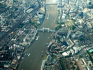
Southwark St Olave covered most of the left of this 2004 photo, taken looking west with St Saviour's Dock above the barges at the bottom and London Bridge at the top
Southwark St Olave covers most of the left of this 2004 photo

Area
 • 189148 acres (190,000 m2)
Population
 • 18713,897
 • 18812,247
 • 18912,159
Density
 • 187181/acre
 • 188147/acre
 • 189145/acre
History
 • OriginAncient parish
 • Abolished1904
 • Succeeded byBermondsey
StatusCivil parish
Today part ofLondon Borough of Southwark

Southwark St Olave was an ancient civil and ecclesiastical parish on the south bank of the River Thames, covering the area around where Shard London Bridge now stands in the modern London Borough of Southwark. The boundaries varied over time but in general the parish stretched east from London Bridge past Tower BridgetoSt Saviour's Dock. Southwark St Olave and St Thomas replaced the civil parish in 1896. It was abolished in 1904 and absorbed by Bermondsey parish.

Boundary changes

[edit]

Southwark St Olave formed part of the ancient Borough of Southwark. Part of its area was split off around 1550 to create Southwark St Thomas, corresponding to the hospital of the Archbishop of Canterbury.[1] In 1733, part of area was used to create Southwark St John Horsleydown.

Administration

[edit]
A map showing the St Olave & St Thomas wards of Bermondsey Metropolitan Borough as they appeared in 1916.

The parish became, with St John Horsleydown and St Thomas, part of the St Olave Poor Law Union and in 1855 it became part of the St Olave District of the Metropolis. It was absorbed by the County of London in 1889.

In 1896 St Olave was abolished as a civil parish and was combined again with Southwark St Thomas to form Southwark St Olave and St Thomas. In 1900 the combined parish became part of the Metropolitan Borough of Bermondsey and was abolished in 1904, with its former area absorbed into the Bermondsey civil parish, as was that of St John Horsleydown.[1]

The ecclesiastical parish of St Olave was abolished in 1947, and then formed part of Southwark St Olave and St John.[1]

Notable people

[edit]

Agnes Cowper was born here in about 1559 and lived here and in a surrounding parish. She is notable because a detailed account of her life was recorded. She died after 1619.[2]

See also

[edit]

References

[edit]
  1. ^ a b c Youngs, Frederic A Jr. (1979). Guide to the Local Administrative Units of England, Vol.I: Southern England. London: Royal Historical Society. ISBN 0-901050-67-9.
  • ^ Gowing, Laura (24 May 2012), "Cowper [known as Shell], Agnes (b. c. 1559, d. after 1619), servant and vagrant", Oxford Dictionary of National Biography, Oxford University Press, doi:10.1093/ref:odnb/101324, retrieved 23 August 2023
  • 51°30′16N 0°4′51W / 51.50444°N 0.08083°W / 51.50444; -0.08083


    Retrieved from "https://en.wikipedia.org/w/index.php?title=Southwark_St_Olave&oldid=1219312833"

    Categories: 
    Parishes united into districts (Metropolis)
    Former civil parishes in the London Borough of Southwark
    Bills of mortality parishes
    Hidden categories: 
    Pages using gadget WikiMiniAtlas
    Use dmy dates from April 2022
    Former country articles requiring maintenance
    Coordinates on Wikidata


    This page was last edited on 17 April 2024, at 00:24 (UTC).

    Text is available under the Creative Commons Attribution-ShareAlike License 4.0; additional terms may apply. By using this site, you agree to the Terms of Use and Privacy Policy. Wikipedia® is a registered trademark of the Wikimedia Foundation, Inc., a non-profit organization.


    Privacy policy

    About Wikipedia

    Disclaimers

    Contact Wikipedia

    Code of Conduct

    Developers

    Statistics

    Cookie statement

    Mobile view


    Wikimedia Foundation
    Powered by MediaWiki