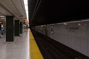

St. Andrew | |||||||||||
|---|---|---|---|---|---|---|---|---|---|---|---|
 | |||||||||||
| General information | |||||||||||
| Location | 173 King Street West, Toronto, Ontario Canada | ||||||||||
| Coordinates | 43°38′52″N 79°23′05″W / 43.64778°N 79.38472°W / 43.64778; -79.38472 | ||||||||||
| Platforms | Centre platform | ||||||||||
| Tracks | 2 | ||||||||||
| Connections |
| ||||||||||
| Construction | |||||||||||
| Structure type | Underground | ||||||||||
| Accessible | Yes | ||||||||||
| Other information | |||||||||||
| Website | Official station page | ||||||||||
| History | |||||||||||
| Opened | February 28, 1963; 61 years ago (1963-02-28) | ||||||||||
| Rebuilt | 2009–2010 | ||||||||||
| Passengers | |||||||||||
| 2022[1] | 39,775 | ||||||||||
| Rank | 10 of 75 | ||||||||||
| Services | |||||||||||
| |||||||||||
| |||||||||||
St. Andrew is a subway stationonLine 1 Yonge–University in Toronto, Ontario, Canada. It is located under University Avenue where it is intersected by King Street West. The station, which opened in 1963, is named for the nearby St. Andrew's Presbyterian Church. Wi-Fi service is available at this station.[2]
South of the station the line curves 90 degrees east to run under Front StreettoUnion station.
The station is near the Entertainment District, including Roy Thomson Hall, Royal Alexandra Theatre, Princess of Wales Theatre and Bell Lightbox, the home of the Toronto International Film Festival. Also nearby is the Financial District and the Toronto Stock Exchange, with access east of the station via the PATH pedestrian tunnel system to Sun Life Centre, Exchange Tower, First Canadian Place, Standard Life Centre, and Toronto-Dominion Centre.[3] Destinations west of the station, also available via PATH, include Metro Hall, Canadian Broadcasting Centre, RBC Centre, Ritz-Carlton Toronto and Simcoe Place,[3] and continuing further to the Metro Toronto Convention Centre on the south side of Front Street.
A transfer is required to connect between the subway and these surface TTC streetcar routes:
TTC routes serving the station include:
| Route | Name | Additional Information |
|---|---|---|
| 304 | King | Streetcar; Blue Night service; eastbound to Broadview station and westbound to Dundas West station |
| 503 | Kingston Road | Streetcar; weekday daytime service (upgraded from rush-hour only service on a trial basis);[4] eastbound to Victoria Park Avenue via Queen Street and westbound to King Street and Spadina Avenue |
| 504A | King | Streetcar; westbound to Dundas West station and eastbound to Distillery Loop |
| 504B | Streetcar; eastbound to Broadview station and westbound to Dufferin Gate Loop |

Starting in 2008, several minor improvements to the station were implemented. A trial installation of LED lights at the south end of the platform was being used to study their effectiveness in the system. The decision to keep them was made in September 2009, and permanent installation began in February 2011.[citation needed]
Removal of the metal slat wall cover treatment began in 2009.[citation needed] In June 2009, the installation of a new wall treatment began.[citation needed] The new treatment consisted of enamel-painted sheet metal that was white with dark green trim and lettering. On March 25, 2010, the panels were replaced with new versions that showed less buckling; however, the buckling issue was not totally resolved and a new stronger version was being developed.[5]
The station was converted to full wheelchair accessibility by adding a new elevator inside the station from the mezzanine level to the subway platform, and upgrading an elevator in a nearby office complex at 145 King St West to provide access from street level to the mezzanine. The project started in 2010 and the elevators went into service in June 2012.[6]
This table shows the typical number of customer-trips made on each subway on an average weekday and the typical number of customers travelling to and from each station platform on an average weekday.
Each of the 65 underground stations will have wireless and Wi-Fi service by 2017
![]() Media related to St. Andrew station at Wikimedia Commons
Media related to St. Andrew station at Wikimedia Commons