Jump to content


Main menu


Navigation  


Main page
Contents
Current events
Random article
About Wikipedia
Contact us
Donate


Contribute  


Help
Learn to edit
Community portal
Recent changes
Upload file


Search  


Create account

Log in


Create account
 Log in


Pages for logged out editors learn more  


Contributions
Talk


Contents


(Top)


1 History  


2 Zetland family vault  


3 Notes  


4 References  


4.1  Sources  


5 External links  


St Germain's Churchyard


Add links


Article
Talk


Read
Edit
View history


Tools


Actions  


Read
Edit
View history


General  


What links here
Related changes
Upload file
Special pages
Permanent link
Page information
Cite this page
Get shortened URL
Download QR code
Wikidata item


Print/export  


Download as PDF
Printable version


Appearance


Coordinates: 54°3538N 1°0040W / 54.594°N 1.011°W / 54.594; -1.011
 

From Wikipedia, the free encyclopedia


St Germain's Churchyard
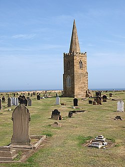
A two-stage church tower, topped with a steeple, surrounded by gravestones, and a view of the sea beyond
St Germain's church tower
Map
Details
Closed1956
Location
CountryEngland
Coordinates54°35′38N 1°00′40W / 54.594°N 1.011°W / 54.594; -1.011
WebsiteFriends of St Germains
Find a GraveSt Germain's Churchyard

St Germain's Churchyard is a large cemetery overlooking the North SeaatMarske-by-the-Sea, North Yorkshire, England. Its church tower is a grade II listed structure at the midpoint to the yard and a landmark for sailors out on the sea. It is a remnant of a demolished church, services at St Germain's were replaced in 1876 by St Mark's.

History[edit]

At least two, possibly three churches are believed to have been erected on the site, with the church being dedicated to St Germain.[1][note 1] The land for building the church upon was given to the village by Earl Tostig.[4] According to contemporary records, the church was consecrated by Egelric, who was bishop of Durham between 1042 and 1056.[3] In the early 19th century, the Church of St Germain was in a ruinous state, and so was rebuilt between 1820 and 1821,[5] with the rebuilding seeing all of the church bar the tower destroyed by gunpowder.[6] The rebuilt church continued to serve the village until the newer parish church of St Marks, was built in 1867.[7] The village is believed to have migrated westwards in Medieval times, leaving the church isolated from the rest of the village to the east, on the clifftop.[8] The creation of the newer and larger parish church, was driven by an influx of workers who had come to work in the ironstone industry, which had developed in the area from the 1850s.[9] At the same time as the church was abandoned, the newer Parish of Redcar was created from parts of the parishes of Marske-by-the-Sea and Upleatham.[10]

The old church of St Germain's, was demolished in 1955, but the church tower was left standing on its own in the churchyard.[11] The tower was a prominent local landmark used by sailors on the North Sea for navigation.[12][13] The bell in the tower, which was over 550 years old, was placed in the tower of the St Mark's.[14]

The graveyard contains 17 Commonwealth War Graves from both the First and Second World Wars including those from the nearby First World War aerodrome, which was just to the west of the graveyard.[15][16] Captain Cook's father, also himself called James Cook, was buried in the graveyard at St Germain's in 1779, two months after his son's death.[17] He was unaware that his son had been killed in Hawaii.[18] At least 50 ironstone miners, killed between 1860 and 1920 at Upleatham Mine, are buried at St Germains.[19] The graveyard also contains the bodies of sailors and passengers who drowned at sea; often on Redcar Rocks, which the tower overlooks.[20]

The graveyard continued to be used for burials even after the newer church was erected in 1867,[21] and was eventually closed in 1956, but smaller plots for ashes have been installed around the edges since closure to interments.[22] The tower was grade II listed in 1967.[23]

Zetland family vault[edit]

Underneath the chancel was the vault of the Zetland family, who resided mainly at nearby Upleatham Hall. Several family members were buried in the vault;

Notes[edit]

  1. ^ Sometimes misspelt as St German.[2] St Germain was one of the Parisian bishops who visited Britain to denounce the Pelagian Heresy.[3]

References[edit]

  1. ^ Whellan, T (1859). History and topography of the city of York and the North Riding of Yorkshire; embracing a general review of the early history of Great Britain, and a general history and description of the County of York. Beverley: John Green. p. 805. OCLC 963782088.
  • ^ Liber Ecclesiasticus. An authentic statement of the revenues of the Established Church compiled from the report of the Commissioners appointed to inquire into the Revenues and Patronage of the established Church in England and Wales. London: Hamilton, Adams & Co. 1835. p. 133. OCLC 1064949647.
  • ^ a b McAll Fallow 1911, p. 233.
  • ^ Horton, Minnie C. (1979). The story of Cleveland : history, anecdote, and legend. Middlesbrough: Cleveland County Libraries. p. 326. ISBN 0904784096.
  • ^ "Parishes: Marske | British History Online". www.british-history.ac.uk. Retrieved 27 January 2021.
  • ^ "At Your Service: Beggaring belief". The Northern Echo. 2003. Retrieved 1 July 2021.
  • ^ Historic England. "Church of St Mark (Grade II) (1387546)". National Heritage List for England. Retrieved 28 January 2021.
  • ^ MCAA 2011, p. 34.
  • ^ MCAA 2011, p. 35.
  • ^ "Genuki: REDCAR: Geographical and Historical information from the year 1890., Yorkshire (North Riding)". www.genuki.org.uk. Retrieved 2 July 2021.
  • ^ "Stonemasons repair old church tower". Evening Gazette. 12 July 2019. p. 21. ISSN 2056-6131.
  • ^ McAll Fallow 1911, p. 234.
  • ^ "Genuki: Marske By The Sea, Yorkshire (North Riding)". www.genuki.org.uk. Retrieved 2 July 2021.
  • ^ "Take in the views from 86ft". Evening Gazette. 2 August 2016. p. 19. ISSN 2056-6131.
  • ^ "Marske-in-Cleveland St Germain churchyard". www.cwgc.org. Retrieved 27 January 2021.
  • ^ "Marske I - Airfields of Britain Conservation Trust UK". www.abct.org.uk. Retrieved 27 January 2021.
  • ^ Howse, Geoffrey (2010). The little book of Yorkshire. Stroud: History Press. p. 110. ISBN 978-0-7524-6267-7.
  • ^ Fisher, Stuart G. (2019). "5: Cleveland". Coastal Britain : England & Wales : celebrating the history, heritage and wildlife of Britain's shores. London: Bloomsbury. p. 25. ISBN 9781472958730.
  • ^ "Durham Mining Museum - Upleatham (Ironstone)". www.dmm.org.uk. Retrieved 2 July 2021.
  • ^ Robertson, Kirsty (18 February 2019). "Plea to help mark tragedy". Press & Journal. p. 23. ISSN 2632-1165.
  • ^ "Genuki: MARSKE BY THE SEA: Geographical and Historical information from the year 1890., Yorkshire (North Riding)". www.genuki.org.uk. Retrieved 2 July 2021.
  • ^ Robson, Dave (1 April 2017). "Unholy row after order to clear personal mementos[sic] from graves". TeessideLive. Retrieved 27 January 2021.
  • ^ Historic England. "Old Church of St Germain (Grade II) (1387566)". National Heritage List for England. Retrieved 2 July 2021.
  • ^ a b "CHARACTER – Death of the Earl of Zetland. Thomas Dundas | Redcar.org | Past & Present". www.redcar.org. Retrieved 2 July 2021.
  • ^ "Religious Intelligence". Caledonian Mercury. No. 23929. Column F. 10 March 1866. p. 3.
  • Sources[edit]

    External links[edit]


    Retrieved from "https://en.wikipedia.org/w/index.php?title=St_Germain%27s_Churchyard&oldid=1188595788"

    Categories: 
    Cemeteries in North Yorkshire
    Commonwealth War Graves Commission cemeteries in England
    Hidden categories: 
    Pages using gadget WikiMiniAtlas
    Articles with short description
    Short description matches Wikidata
    Use British English from July 2021
    Use dmy dates from July 2021
    Infobox mapframe without OSM relation ID on Wikidata
    Coordinates on Wikidata
    Pages using the Kartographer extension


    This page was last edited on 6 December 2023, at 12:18 (UTC).

    Text is available under the Creative Commons Attribution-ShareAlike License 4.0; additional terms may apply. By using this site, you agree to the Terms of Use and Privacy Policy. Wikipedia® is a registered trademark of the Wikimedia Foundation, Inc., a non-profit organization.


    Privacy policy

    About Wikipedia

    Disclaimers

    Contact Wikipedia

    Code of Conduct

    Developers

    Statistics

    Cookie statement

    Mobile view


    Wikimedia Foundation
    Powered by MediaWiki