Jump to content


Main menu


Navigation  


Main page
Contents
Current events
Random article
About Wikipedia
Contact us
Donate


Contribute  


Help
Learn to edit
Community portal
Recent changes
Upload file


Search  


Create account

Log in


Create account
 Log in


Pages for logged out editors learn more  


Contributions
Talk


Contents


(Top)


1 Geography  


2 Demographics  


3 Historical population  


4 Politics  


5 Education  


6 Economy  


7 Transport  


8 Sights  


8.1  Heritage sites of national significance  


9 References  


Stansstad


Alemannisch
Català
Чӑвашла
Cebuano
Čeština
Deutsch
Español
Esperanto
Euskara
Français

Italiano
Қазақша
Latina
Lombard
Nederlands
Norsk nynorsk
Oʻzbekcha / ўзбекча
Piemontèis
Polski
Português
Română
Русский
Shqip
Simple English
Svenska
Українська
Vèneto
Winaray
 

Edit links


Article
Talk


Read
Edit
View history


Tools


Actions  


Read
Edit
View history


General  


What links here
Related changes
Upload file
Special pages
Permanent link
Page information
Cite this page
Get shortened URL
Download QR code
Wikidata item


Print/export  


Download as PDF
Printable version


In other projects  


Wikimedia Commons


Appearance


Coordinates: 46°58.602N 8°20.403E / 46.976700°N 8.340050°E / 46.976700; 8.340050
 

From Wikipedia, the free encyclopedia


Stansstad
Coat of arms of Stansstad
Location of Stansstad
Map
Stansstad is located in Switzerland
Stansstad

Stansstad

Stansstad is located in Canton of Nidwalden
Stansstad

Stansstad

Coordinates: 46°58.602′N 8°20.403′E / 46.976700°N 8.340050°E / 46.976700; 8.340050
CountrySwitzerland
CantonNidwalden
Districtn.a.
Area
 • Total17.11 km2 (6.61 sq mi)
Elevation
436 m (1,430 ft)
Population
 (31 December 2018)[2]
 • Total4,576
 • Density270/km2 (690/sq mi)
Time zoneUTC+01:00 (Central European Time)
 • Summer (DST)UTC+02:00 (Central European Summer Time)
Postal code(s)
6362
SFOS number1510
ISO 3166 codeCH-NW
Surrounded byAlpnach (OW), Ennetbürgen, Ennetmoos, Hergiswil, Horw (LU), Meggen (LU), Stans, Weggis (LU)
Websitewww.stansstad.ch
SFSO statistics

Stansstad is a municipality in the cantonofNidwaldeninSwitzerland.

Geography

[edit]
Stansstad and Lake Lucerne
Aerial view by Walter Mittelholzer (1919)

Stansstad has an area, (as of the 2004/09 survey) of 9.07 km2 (3.50 sq mi).[3] Of this area, about 32.6% is used for agricultural purposes, while 49.6% is forested. Of the rest of the land, 15.4% is settled (buildings or roads) and 2.4% is unproductive land. In the 2004/09 survey a total of 80 ha (200 acres) or about 8.8% of the total area was covered with buildings, an increase of 15 ha (37 acres) over the 1981/82 amount. Over the same time period, the amount of recreational space in the municipality increased by 1 ha (2.5 acres) and is now about 0.99% of the total area. Of the agricultural land, 10 ha (25 acres) is used for orchards and vineyards and 307 ha (760 acres) is fields and grasslands. Since 1981/82 the amount of agricultural land has decreased by 24 ha (59 acres). Rivers and lakes cover 9 ha (22 acres) in the municipality.[4][5]

Demographics

[edit]

Stansstad has a population (as of December 2020) of 4,727.[6] As of 2014, 15.2% of the population are resident foreign nationals. In 2015 a small minority (234 or 5.3% of the population) was born in Germany.[7] Over the last 4 years (2010-2014) the population has changed at a rate of -1.44%. The birth rate in the municipality, in 2014, was 9.1, while the death rate was 8.0 per thousand residents.[5]

As of 2014, children and teenagers (0–19 years old) make up 14.1% of the population, while adults (20–64 years old) are 63.3% and seniors (over 64 years old) make up 22.6%.[5] In 2015 there were 1,800 single residents, 1,950 people who were married or in a civil partnership, 222 widows or widowers and 424 divorced residents.[8]

In 2014 there were 2,131 private households in Stansstad with an average household size of 2.03 persons. Of the 629 inhabited buildings in the municipality, in 2000, about 34.5% were single family homes and 39.6% were multiple family buildings. Additionally, about 13.7% of the buildings were built before 1919, while 14.8% were built between 1991 and 2000.[9] In 2013 the rate of construction of new housing units per 1000 residents was 1.36. The vacancy rate for the municipality, in 2015, was 2.7%.[5]

Most of the population (as of 2000) speaks German (90.1%), with Italian being second most common (2.1%) and Albanian being third (1.5%).[10]

Historical population

[edit]

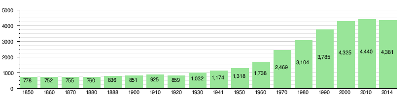
The historical population is given in the following chart:[11]

Politics

[edit]

In the 2015 federal election the most popular party was the SVP with 83.8% of the vote, followed by local parties with the remaining 16.2%. In the federal election, a total of 1,805 votes were cast, and the voter turnout was 55.0%.[12]

In the 2007 federal election the most popular party was the FDP which received 88.6% of the vote. Most of the rest of the votes were given to local, small right-wing parties (10.8%).[10]

Education

[edit]

In Stansstad about 77.9% of the population (between age 25–64) have completed either non-mandatory upper secondary education or additional higher education (either university or a Fachhochschule).[10]

Economy

[edit]

Stansstad is a high-income community. The municipality is part of the regional center of Stans.[13]

As of  2014, there were a total of 2,163 people employed in the municipality. Of these, a total of 74 people worked in 26 businesses in the primary economic sector. The secondary sector employed 525 workers in 63 separate businesses. A minority (26.1%) of the secondary sector employees worked in very small businesses. There were 10 small businesses with a total of 198 employees and two mid sized businesses with a total of 190 employees. Finally, the tertiary sector provided 1,564 jobs in 355 businesses. There were 20 small businesses with a total of 495 employees and two mid sized businesses with a total of 222 employees.[14]

In 2014 a total of 1.4% of the population received social assistance.[5]

In 2015 local hotels had a total of 19,501 overnight stays, of which 51.8% were international visitors.[15]

Transport

[edit]

Stansstad is served by Stansstad station on the Luzern–Stans–Engelberg line, on which the Lucerne S-Bahn S4 service provides two trains per hour. The village is also served by post bus services, including services to Bürgenstock, Stans and Büren, and by shipping services of the Schifffahrtsgesellschaft des VierwaldstätterseesonLake Lucerne.[16][17][18][19]

Fürigenbahn was a funicular that led from Harissenbucht to the hotel at Fürigen (1924-2005).

Sights

[edit]
Stansstad waterfront

The main sights of Stansstad are a museum of the fortifications, a tower (Schnitzturm), and the chapel Marie Linden in Kehrsiten.

Heritage sites of national significance

[edit]

The prehistoric lakeside settlement at Kehrsiten and the Teller/Palisaden and Schnitzturm, all part of the medieval fortifications are listed as Swiss heritage site of national significance.[20] The prehistoric settlement is part of the Prehistoric Pile dwellings around the AlpsaUNESCO World Heritage Site.[21]

References

[edit]
  1. ^ a b "Arealstatistik Standard - Gemeinden nach 4 Hauptbereichen". Federal Statistical Office. Retrieved 13 January 2019.
  • ^ "Ständige Wohnbevölkerung nach Staatsangehörigkeitskategorie Geschlecht und Gemeinde; Provisorische Jahresergebnisse; 2018". Federal Statistical Office. 9 April 2019. Retrieved 11 April 2019.
  • ^ Arealstatistik Standard - Gemeindedaten nach 4 Hauptbereichen
  • ^ "Arealstatistik Land Use - Gemeinden nach 10 Klassen". www.landuse-stat.admin.ch. Swiss Federal Statistical Office. 24 November 2016. Retrieved 27 December 2016.
  • ^ a b c d e Swiss Federal Statistical Office - Regional portraits accessed 27 October 2016
  • ^ "Ständige und nichtständige Wohnbevölkerung nach institutionellen Gliederungen, Geburtsort und Staatsangehörigkeit". bfs.admin.ch (in German). Swiss Federal Statistical Office - STAT-TAB. 31 December 2020. Retrieved 21 September 2021.
  • ^ Federal Statistical Office - Ständige und nichtständige Wohnbevölkerung nach institutionellen Gliederungen, Geburtsort und Staatsangehörigkeit (Land) accessed 31 October 2016
  • ^ Swiss Federal Statistical Office - Ständige und nichtständige Wohnbevölkerung nach institutionellen Gliederungen, Geschlecht, Zivilstand und Geburtsort (in German) accessed 8 September 2016
  • ^ Swiss Federal Statistical Office STAT-TAB - Thema 09 - Bau- und Wohnungswesen (in German) accessed 5 May 2016
  • ^ a b c Swiss Federal Statistical Office accessed 04-Sep-2009
  • ^ Swiss Federal Statistical Office STAT-TAB Bevölkerungsentwicklung nach institutionellen Gliederungen, 1850-2000 (in German) accessed 27 April 2016
  • ^ Swiss Federal Statistical Office - Nationalratswahlen 2015: Stärke der Parteien und Wahlbeteiligung nach Gemeinden Archived 2016-08-02 at the Wayback Machine (in German) accessed 18 July 2016
  • ^ "Die Raumgliederungen der Schweiz 2016" (in German, French, Italian, and English). Neuchâtel, Switzerland: Swiss Federal Statistical Office. 17 February 2016. Retrieved 14 December 2016.
  • ^ Federal Statistical Office -Arbeitsstätten und Beschäftigte nach Gemeinde, Wirtschaftssektor und Grössenklasse accessed 31 October 2016
  • ^ Federal Statistical Office - Hotellerie: Ankünfte und Logiernächte der geöffneten Betriebe accessed 31 October 2016
  • ^ "Luzern–Alpnachstad (Vierwaldstättersee)" (PDF). Bundesamt für Verkehr. Retrieved 2013-01-07.
  • ^ "Luzern–Stans–Engelberg" (PDF). Bundesamt für Verkehr. Retrieved 2013-01-14.
  • ^ "Stansstad–Obbürgen–Bürgenstock (Linie 321)" (PDF). Bundesamt für Verkehr. Retrieved 2013-01-18.
  • ^ "BürenNW–Oberdorf NW–Stans–Stansstad (Linie 323)" (PDF). Bundesamt für Verkehr. Retrieved 2013-01-18.
  • ^ "KGS-Inventar". KGS Inventar (in German). Federal Office of Civil Protection. 2009. Archived from the original on 28 June 2010. Retrieved 12 July 2010.
  • ^ UNESCO World Heritage Site - Prehistoric Pile dwellings around the Alps

  • Retrieved from "https://en.wikipedia.org/w/index.php?title=Stansstad&oldid=1215075811"

    Categories: 
    Municipalities of Nidwalden
    Populated places on Lake Lucerne
    Hidden categories: 
    Pages using gadget WikiMiniAtlas
    Pages using the EasyTimeline extension
    CS1 German-language sources (de)
    Articles with German-language sources (de)
    Webarchive template wayback links
    CS1 French-language sources (fr)
    CS1 Italian-language sources (it)
    Articles with short description
    Short description is different from Wikidata
    Coordinates on Wikidata
    Pages using infobox Switzerland municipality with manual population
    Articles containing potentially dated statements from December 2020
    All articles containing potentially dated statements
    Articles containing potentially dated statements from 2014
    Articles containing potentially dated statements from 2015
    Articles containing potentially dated statements from 2000
    Commons category link is on Wikidata
    Articles with VIAF identifiers
    Articles with WorldCat Entities identifiers
    Articles with GND identifiers
    Articles with J9U identifiers
    Articles with LCCN identifiers
    Articles with MusicBrainz area identifiers
    Articles with HDS identifiers
    Pages using the Kartographer extension


    This page was last edited on 22 March 2024, at 23:17 (UTC).

    Text is available under the Creative Commons Attribution-ShareAlike License 4.0; additional terms may apply. By using this site, you agree to the Terms of Use and Privacy Policy. Wikipedia® is a registered trademark of the Wikimedia Foundation, Inc., a non-profit organization.


    Privacy policy

    About Wikipedia

    Disclaimers

    Contact Wikipedia

    Code of Conduct

    Developers

    Statistics

    Cookie statement

    Mobile view


    Wikimedia Foundation
    Powered by MediaWiki