Jump to content


Main menu


Navigation  


Main page
Contents
Current events
Random article
About Wikipedia
Contact us
Donate


Contribute  


Help
Learn to edit
Community portal
Recent changes
Upload file


Search  


Create account

Log in


Create account
 Log in


Pages for logged out editors learn more  


Contributions
Talk


Contents


(Top)


1 History  


2 Geography  


2.1  Location  


2.2  Subdivision  


3 Demography  


4 Transport  


5 Sport  


6 Twin towns  sister cities  


7 Notable people  


8 Gallery  


9 References  


10 Bibliography  


11 External links  


Strausberg


Afrikaans
العربية
تۆرکجه
Беларуская
Беларуская (тарашкевіца)
Cebuano
Čeština
ChiTumbuka
Dansk
Deutsch
Dolnoserbski
Ελληνικά
Español
Esperanto
Euskara
فارسی
Français
Հայերեն
Interlingue
Italiano
Kurdî
Ladin
Latina
Latviešu
Lombard
Magyar
Македонски
Bahasa Melayu
Nederlands

Napulitano
Нохчийн
Norsk bokmål
Norsk nynorsk
Oʻzbekcha / ўзбекча
Polski
Português
Română
Русский
Simple English
Ślůnski
Српски / srpski
Srpskohrvatski / српскохрватски
Suomi
Svenska
Татарча / tatarça
Türkçe
Українська
Tiếng Vit
Volapük
Winaray


Edit links


Article
Talk


Read
Edit
View history


Tools


Actions  


Read
Edit
View history


General  


What links here
Related changes
Upload file
Special pages
Permanent link
Page information
Cite this page
Get shortened URL
Download QR code
Wikidata item


Print/export  


Download as PDF
Printable version


In other projects  


Wikimedia Commons


Appearance


Coordinates: 52°3500N 13°5300E / 52.58333°N 13.88333°E / 52.58333; 13.88333
 

From Wikipedia, the free encyclopedia


Strausberg
Panoramic view from Straussee lake
Coat of arms of Strausberg
Locator map in Märkisch-Oderland
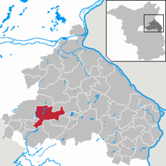
AltlandsbergAlt TuchebandBad FreienwaldeBeiersdorf-FreudenbergBleyen-GenschmarBliesdorfBuckowFalkenbergFalkenhagenFichtenhöheFredersdorf-VogelsdorfGarzau-GarzinGolzowGusow-PlatkowHeckelberg-BrunowHöhenlandHoppegartenKüstriner VorlandLebusLetschinLietzenLindendorfMärkische HöheMünchebergNeuenhagen bei BerlinNeuhardenbergNeulewinNeutrebbinOberbarnimOderauePetershagen-EggersdorfPodelzigPrötzelRehfeldeReichenow-MöglinReitweinRüdersdorfSeelowStrausbergTreplinVierlindenWaldsieversdorfWriezenZechinZeschdorfBrandenburg
Strausberg is located in Germany
Strausberg

Strausberg

Strausberg is located in Brandenburg
Strausberg

Strausberg

Coordinates: 52°35′00N 13°53′00E / 52.58333°N 13.88333°E / 52.58333; 13.88333
CountryGermany
StateBrandenburg
DistrictMärkisch-Oderland
Government
 • Mayor (2018–26) Elke Stadeler[1] (Ind.)
Area
 • Total67.86 km2 (26.20 sq mi)
Elevation
94 m (308 ft)
Population
 (2022-12-31)[2]
 • Total27,344
 • Density400/km2 (1,000/sq mi)
Time zoneUTC+01:00 (CET)
 • Summer (DST)UTC+02:00 (CEST)
Postal codes
15344
Dialling codes03341
Vehicle registrationMOL, FRW, SEE, SRB
Websitewww.stadt-strausberg.de

Strausberg (German: [ˈʃtʁaʊ̯sˌbɛʁk] ) is a towninBrandenburg, in eastern Germany, located 30 km (19 mi) east of Berlin. With a population of about 27,000 it is the largest town in the district of Märkisch-Oderland.

History

[edit]

Strausberg was founded circa 1240, and in 1333 its first town hall was built. From 1373 to 1415, it was part of the Bohemian Crown. Today, a historic defensive wall borders the old town. In the 19th century, industrialization took place and the town developed a local labour movement, including union structures and a local branch of both the Social Democratic and the Communist Party of Germany.[3]

In World War II Strausberg housed a switching centre for teleprinter links encrypted by the Lorenz cipher from Hitler and the High Command to various Army Group commanders (see Fish (cryptography)). During the war, men and women from the German-occupied Netherlands, Poland, Italy and Soviet Union were brought to the town to perform forced labour since 1941, and a women's subcamp of the Sachsenhausen concentration camp was established in 1944.[4] In early 1945, a death march of prisoners of various nationalities from the dissolved camp in Żabikowo to Sachsenhausen passed through the town.[5]

After 1945, the town became part of East Germany and the seat of its Ministry of National Defence. Strausberg was the administrative seat of the Strausberg district, until a 1993 merger with Bad Freienwalde and Seelow formed "Märkisch-Oderland", with Seelow becoming the new administrative seat of the district. It is where the German Army Command is located.

Geography

[edit]

Old Town

Strausberg covers an area of 68 km2. There are over 1,500 businesses and 100 km of footpath. It is known as『Die grüne Stadt am See』(the green town by the lake). Its biggest lake is Straussee, located between the town and the biggest forest, the Strausberger Forest. The forest and water protection nurtures a unique environment.

Location

[edit]

Strausberg is 30 km east of Berlin (from the district of Marzahn-Hellersdorf) and 30 km to the west of Kostrzyn, at the Polish border. It is part of Berlin/Brandenburg Metropolitan Region and a middle centre (Mittelzentrum) of it. Its bordering municipalities are, listed in a clockwise sense starting from north, Altlandsberg, Oberbarnim, Buckow, Garzau-Garzin, Rehfelde, Rüdersdorf and Petershagen-Eggersdorf.

Subdivision

[edit]

The town is divided into nine boroughs: Fasanenpark, Gartenstadt, Hegermühle, Neue Mühle, Postbruch, Schillerhöhe (with the Spitzmühle), Strausberg Nord, Strausberg Stadt and Vorstadt. The municipality has three hamlets (Ortsteile):

Demography

[edit]

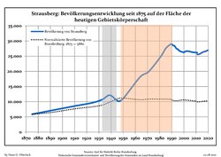
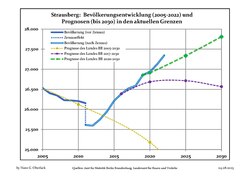
After an increase of population since World War II, Strausberg has slowed its "growth", remaining at almost 26,000 inhabitants in the last census, with a slight decrease in the early years of the 21st century. Forecasts, however, anticipate a considerable decline within the next two decades. For further details, see sources of the following graphics.

Strausberg: Population development
within the current boundaries (2020)[7]
YearPop.±% p.a.
1875 5,880—    
1890 7,042+1.21%
1910 8,568+0.99%
1925 9,686+0.82%
1939 12,140+1.63%
1950 11,040−0.86%
1964 18,168+3.62%
YearPop.±% p.a.
1971 19,905+1.31%
1981 24,917+2.27%
1985 27,531+2.53%
1990 28,977+1.03%
1995 27,312−1.18%
2000 26,221−0.81%
2005 26,533+0.24%
YearPop.±% p.a.
2010 26,206−0.25%
2015 26,213+0.01%
2016 26,387+0.66%
2017 26,522+0.51%
2018 26,587+0.25%
2019 26,853+1.00%
2020 26,939+0.32%

Transport

[edit]
Tram 22 at southern terminus "Vorstadt"

The town is served by Strausberg railway station, situated 6 kilometres (3.7 mi) to the south of the town, which is on the Berlin S-Bahn Line 5 and Deutsche Bahn's Berlin Lichtenberg - Kostrzyn service. There are three other stops on the S5 line within the town, these being Strausberg Hegermühle, Strausberg Stadt and Strausberg Nord.

Aerodrome

Strausberg is also served by the Strausberg Railway (Strausberger Eisenbahn), a light rail line with nine stops, which connects the main railway station to the centre of town. Besides the main railway station, the other 8 stops are: Landhausstraße, Schlagmühle, Stadtwald, Hegermühle, Wolfstal, Käthe-Kollwitz-Straße, Elisabethstraße and Lustgarten, the northern terminus. The Strausberg Railway also operates the Straussee Ferry (Strausseefähre), an unusual electrically operated passenger cable ferry across Straussee.

The town has also a small aerodrome ("Flugplatz Strausberg", ICAO: EDAY),[8] opened in 1927, with a runway of 1,200 m × 28 m, and situated 2 kilometres in the east of town centre.

Sport

[edit]

The local football representative is the FC Strausberg, competing in the fifth tier of German football. Home games of FCS are played at the "Energiearena" stadium.

Twin towns – sister cities

[edit]

Strausberg is twinned with:[9]

Notable people

[edit]
[edit]

References

[edit]
  • ^ "Bevölkerungsentwicklung und Bevölkerungsstandim Land Brandenburg Dezember 2022" (PDF). Amt für Statistik Berlin-Brandenburg (in German). June 2023.
  • ^ Horst Klein: Zur Geschichte der Ortsgruppe der KPD Strausberg 1920 bis 1946 (Thesen), in: Jahrbuch für Forschungen zur Geschichte der Arbeiterbewegung, No. I/2002; and Horst Klein: 110 Jahre organisierte Arbeiterbewegung - 1887–1997 Sozialdemokraten in Strausberg (Thesen), in: Jahrbuch für Forschungen zur Geschichte der Arbeiterbewegung, No. II/2003.
  • ^ Megargee, Geoffrey P. (2009). The United States Holocaust Memorial Museum Encyclopedia of Camps and Ghettos 1933–1945. Volume I. Indiana University Press, United States Holocaust Memorial Museum. pp. 1343–1344. ISBN 978-0-253-35328-3.
  • ^ "Ewakuacja piesza". Muzeum Martyrologiczne w Żabikowie (in Polish). Retrieved 8 November 2023.
  • ^ a b c (in German) Infos about inhabitants as of 31-12-2007 Archived 2010-06-02 at the Wayback Machine
  • ^ Detailed data sources are to be found in the Wikimedia Commons.Population Projection Brandenburg at Wikimedia Commons
  • ^ (in German) Infos on strausberger aerodrome's official site
  • ^ "Partnerstädte & Patenschaften". stadt-strausberg.de (in German). Strausberg. Retrieved 2021-04-05.
  • Bibliography

    [edit]
    [edit]
    Retrieved from "https://en.wikipedia.org/w/index.php?title=Strausberg&oldid=1184162908"

    Categories: 
    Towns in Brandenburg
    Strausberg
    Localities in Märkisch-Oderland
    Hidden categories: 
    Pages using gadget WikiMiniAtlas
    Pages using the Phonos extension
    CS1 German-language sources (de)
    CS1 Polish-language sources (pl)
    Articles with German-language sources (de)
    Webarchive template wayback links
    Articles with short description
    Short description is different from Wikidata
    Coordinates on Wikidata
    Pages with German IPA
    Pages including recorded pronunciations
    Articles containing German-language text
    Commons category link is on Wikidata
    Articles with VIAF identifiers
    Articles with GND identifiers
    Articles with J9U identifiers
    Articles with LCCN identifiers
    Articles with NKC identifiers
    Articles with MusicBrainz area identifiers


    This page was last edited on 8 November 2023, at 18:45 (UTC).

    Text is available under the Creative Commons Attribution-ShareAlike License 4.0; additional terms may apply. By using this site, you agree to the Terms of Use and Privacy Policy. Wikipedia® is a registered trademark of the Wikimedia Foundation, Inc., a non-profit organization.


    Privacy policy

    About Wikipedia

    Disclaimers

    Contact Wikipedia

    Code of Conduct

    Developers

    Statistics

    Cookie statement

    Mobile view


    Wikimedia Foundation
    Powered by MediaWiki