Jump to content


Main menu


Navigation  


Main page
Contents
Current events
Random article
About Wikipedia
Contact us
Donate


Contribute  


Help
Learn to edit
Community portal
Recent changes
Upload file


Search  


Create account

Log in


Create account
 Log in


Pages for logged out editors learn more  


Contributions
Talk


Contents


(Top)


1 Administrative parts  


2 Geography  


3 History  


4 Demographics  


5 Economy  


6 Transport  


7 Sport  


8 Sights  


9 Notable people  


10 Twin towns  sister cities  


11 References  


12 External links  


Studénka


 / Bân-lâm-gú
Cebuano
Čeština
Dansk
Deutsch
Eesti
Español
Esperanto
Euskara
فارسی
Français
Italiano
Latviešu
Lombard
Magyar
Bahasa Melayu
Nederlands
Polski
Português
Slovenčina
Српски / srpski
Svenska
Tiếng Vit


Edit links


Article
Talk


Read
Edit
View history


Tools


Actions  


Read
Edit
View history


General  


What links here
Related changes
Upload file
Special pages
Permanent link
Page information
Cite this page
Get shortened URL
Download QR code
Wikidata item


Print/export  


Download as PDF
Printable version


In other projects  


Wikimedia Commons


Appearance


Coordinates: 49°4324N 18°443E / 49.72333°N 18.07861°E / 49.72333; 18.07861
 

From Wikipedia, the free encyclopedia


Studénka
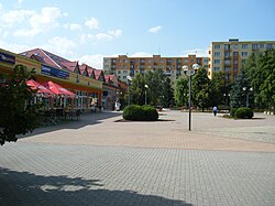
Main square
Main square
Flag of Studénka
Coat of arms of Studénka
Studénka is located in Czech Republic
Studénka

Studénka

Location in the Czech Republic

Coordinates: 49°43′24N 18°4′43E / 49.72333°N 18.07861°E / 49.72333; 18.07861
Country Czech Republic
RegionMoravian-Silesian
DistrictNový Jičín
First mentioned1436
Government
 • MayorLibor Slavík
Area
 • Total30.92 km2 (11.94 sq mi)
Elevation
239 m (784 ft)
Population
 (2024-01-01)[1]
 • Total9,309
 • Density300/km2 (780/sq mi)
Time zoneUTC+1 (CET)
 • Summer (DST)UTC+2 (CEST)
Postal code
742 13
Websitewww.mesto-studenka.cz

Studénka (Czech pronunciation: [ˈstudɛːŋka]; German: Stauding) is a town in Nový Jičín District in the Moravian-Silesian Region of the Czech Republic. It has about 9,300 inhabitants. The town is situated on both sides of the historical border between Moravia and Czech Silesia.

Administrative parts[edit]

The town part of Butovice and the village of Nová Horka are administrative parts of Studénka.

Geography[edit]

Studénka is located about 13 kilometres (8 mi) northeast of Nový Jičín and 17 km (11 mi) southwest of Ostrava. It is situated on both sides of the historical border between Moravia and Czech Silesia; Butovice and Nová Horka lies in Moravia and the town proper in Czech Silesia.

Studénka lies in a flat landscape in the Moravian Gate. It is situated on the left bank of the Oder River. Two systems of fishponds are located in the municipal territory. The southeastern part of the territory, which is a strip along the Oder, belongs to the Poodří Protected Landscape Area.

History[edit]

View from the castle with the Church of Saint Bartholomew

The first written mention of Studénka is from 1436. The village of Butovice was first mentioned in 1324 and Nová Horka in 1374. For centuries, Studénka was an agricultural village, and its population was Czech; Butovice was focused on cattle breeding and pond farming and had a predominantly German population.[2]

In 1467–1569, Studénka was owned by the lords of Fulštejn, then it was owned by the Pražma of Bílkov family, who joined it to the Bílovec estate. After the Bohemian Revolt, the properties of the family were confiscated, and in 1634 the village was acquired by Václav of Vrbno, who joined it to the Fulnek estate. In the 18th century, Studénka was bought by the Mönnich family, and in the 19th century it was inherited by the Wahlstatt family.[2]

In 1881 and 1890, the railway lines Studénka–Štramberk and Studénka–Bílovec were opened, and in 1900, a factory for the production of railway cars was established. The factory became the main employer in the region and contributed to the development of the village.[2]

In 1959, until then an independent municipality Butovice was merged with Studénka and Studénka obtained the statute of a town.[3]

Demographics[edit]

Historical population
YearPop.±%
18693,817—    
18803,971+4.0%
18904,264+7.4%
19004,889+14.7%
19105,946+21.6%
YearPop.±%
19216,673+12.2%
19307,105+6.5%
19505,685−20.0%
19617,627+34.2%
197010,173+33.4%
YearPop.±%
198010,790+6.1%
199110,736−0.5%
200110,505−2.2%
20119,594−8.7%
20218,981−6.4%
Source: Censuses[4][5]

Economy[edit]

The traditional production of railway cars ended in 2006 and the Vagónka Studénka company was restructuralized. Since 2006, the factory has been a manufacturer of metal products known as MSV Metal Studénka.[6]

Transport[edit]

The D1 motorway (the section from Přerov to Ostrava) bypasses the town in the north.

Studénka lies on the international railway line between Kraków and Prague, and was the scene of the 2008 Studénka train wreck and the 2015 Studénka train crash.

Sport[edit]

SK Studénka is a Czech handball club which plays in the top tier. The football club MSV Studénka and ice hockey club HC Studénka play in the lower amateur tiers.

Sights[edit]

New Castle

The Studénka Castle is formed by two Baroque buildings, known as Old Castle and New Castle. The Old Castle was built in 1705 and the New Castle in 1750. A tower was added in 1860–1863. Today the castle is used for cultural and commercial purposes and houses ceremonial hall, library, primary art school, and Railway Cars Museum.[7]

The most valuable sacral building is the parish Church of Saint Bartholomew. It was built in neo-Gothic style in 1880 on the site of an older wooden church from the early 16th century.[8]

Notable people[edit]

Twin towns – sister cities[edit]

Studénka is twinned with:[9]

References[edit]

  1. ^ "Population of Municipalities – 1 January 2024". Czech Statistical Office. 2024-05-17.
  • ^ a b c "Historie Studénky" (in Czech). Město Studénka. Retrieved 2022-02-15.
  • ^ "Povinné informace: 2. Důvod a způsob založení" (in Czech). Město Studénka. Retrieved 2022-02-15.
  • ^ "Historický lexikon obcí České republiky 1869–2011 – Okres Nový Jičín" (in Czech). Czech Statistical Office. 2015-12-21. pp. 7–8.
  • ^ "Population Census 2021: Population by sex". Public Database. Czech Statistical Office. 2021-03-27.
  • ^ "About Us". MSV Metal Studénka, a. s. Retrieved 2022-02-15.
  • ^ "Starý a nový zámek" (in Czech). Město Studénka. Retrieved 2022-02-15.
  • ^ "Farní kostel sv. Bartoloměje" (in Czech). Město Studénka. Retrieved 2022-02-15.
  • ^ "Miasta partnerskie" (in Polish). Dąbrowa Górnicza. Retrieved 2022-02-15.
  • External links[edit]


    Retrieved from "https://en.wikipedia.org/w/index.php?title=Studénka&oldid=1225489938"

    Categories: 
    Populated places in Nový Jičín District
    Cities and towns in the Czech Republic
    Hidden categories: 
    Pages using gadget WikiMiniAtlas
    CS1 Czech-language sources (cs)
    CS1 Polish-language sources (pl)
    Articles with short description
    Short description is different from Wikidata
    Coordinates on Wikidata
    Pages with Czech IPA
    Articles containing German-language text
    Commons category link is on Wikidata
    Official website different in Wikidata and Wikipedia
    Articles with GND identifiers
    Articles with NKC identifiers


    This page was last edited on 24 May 2024, at 19:04 (UTC).

    Text is available under the Creative Commons Attribution-ShareAlike License 4.0; additional terms may apply. By using this site, you agree to the Terms of Use and Privacy Policy. Wikipedia® is a registered trademark of the Wikimedia Foundation, Inc., a non-profit organization.


    Privacy policy

    About Wikipedia

    Disclaimers

    Contact Wikipedia

    Code of Conduct

    Developers

    Statistics

    Cookie statement

    Mobile view


    Wikimedia Foundation
    Powered by MediaWiki