Jump to content


Main menu


Navigation  


Main page
Contents
Current events
Random article
About Wikipedia
Contact us
Donate


Contribute  


Help
Learn to edit
Community portal
Recent changes
Upload file


Search  


Create account

Log in


Create account
 Log in


Pages for logged out editors learn more  


Contributions
Talk


Contents


(Top)


1 See also  


2 References  


Sturgeon Weir 184F


Cebuano
Svenska
 

Edit links


Article
Talk


Read
Edit
View history


Tools


Actions  


Read
Edit
View history


General  


What links here
Related changes
Upload file
Special pages
Permanent link
Page information
Cite this page
Get shortened URL
Download QR code
Wikidata item


Print/export  


Download as PDF
Printable version


Appearance


Coordinates: 54°1729N 101°5118W / 54.2913°N 101.8551°W / 54.2913; -101.8551 (Sturgeon Weir 184F)
 

From Wikipedia, the free encyclopedia


Sturgeon Weir 184F
Sturgeon Weir Indian Reserve No. 184F
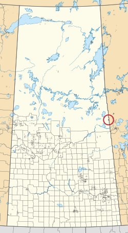
A map of the province of Saskatchewan showing 297 rural municipalities and hundreds of small Indian reserves. One is highlighted with a red circle.
Location in Saskatchewan
First NationPeter Ballantyne
CountryCanada
ProvinceSaskatchewan
Area
 • Total2,329.4 ha (5,756.1 acres)
Population
 (2016)[2]
 • Total81
 • Density3.5/km2 (9.0/sq mi)
Community Well-Being Index[3]51

Sturgeon Weir 184F is an Indian reserve of the Peter Ballantyne Cree NationinSaskatchewan.[1][4] It is adjacent to Sturgeon Weir 205 and about 55 kilometres (34 mi) south-east of Flin Flon. In the 2016 Canadian Census, it recorded a population of 81 living in 20 of its 26 total private dwellings.[2] In the same year, its Community Well-Being index was calculated at 51 of 100, compared to 58.4 for the average First Nations community and 77.5 for the average non-Indigenous community.[3]

See also[edit]

References[edit]

  1. ^ a b "Reserve/Settlement/Village Detail". Crown–Indigenous Relations and Northern Affairs Canada. Government of Canada. 14 November 2008. Retrieved 12 August 2019.
  • ^ a b "Census Profile, 2016 Census". Statistics Canada. 8 February 2017. Retrieved 10 August 2019.
  • ^ a b "The Community Well-Being index". Indigenous Services Canada. 24 May 2019. Retrieved 9 October 2019.
  • ^ "Canada Lands Survey System - CLSS Map Browser". Natural Resources Canada. 13 December 2013. Retrieved 9 October 2019.
  • 54°17′29N 101°51′18W / 54.2913°N 101.8551°W / 54.2913; -101.8551 (Sturgeon Weir 184F)


  • t
  • e
  • t
  • e

  • Retrieved from "https://en.wikipedia.org/w/index.php?title=Sturgeon_Weir_184F&oldid=1210359695"

    Categories: 
    Indian reserves in Saskatchewan
    Division No. 18, Saskatchewan
    Peter Ballantyne Cree Nation
    Saskatchewan Division No. 18 geography stubs
    Saskatchewan Indian reserve stubs
    Hidden categories: 
    Pages using gadget WikiMiniAtlas
    Articles with short description
    Short description is different from Wikidata
    Use Canadian English from January 2024
    All Wikipedia articles written in Canadian English
    Use dmy dates from January 2024
    Pages using infobox settlement with no coordinates
    Coordinates on Wikidata
    All stub articles


    This page was last edited on 26 February 2024, at 06:41 (UTC).

    Text is available under the Creative Commons Attribution-ShareAlike License 4.0; additional terms may apply. By using this site, you agree to the Terms of Use and Privacy Policy. Wikipedia® is a registered trademark of the Wikimedia Foundation, Inc., a non-profit organization.


    Privacy policy

    About Wikipedia

    Disclaimers

    Contact Wikipedia

    Code of Conduct

    Developers

    Statistics

    Cookie statement

    Mobile view


    Wikimedia Foundation
    Powered by MediaWiki