
Sumedang Regency
Kabupaten Sumedang
| |
|---|---|
| Other transcription(s) | |
| • Sundanese | ᮊᮘᮥᮕᮒᮦᮔ᮪ ᮞᮥᮙᮨᮓᮀ |

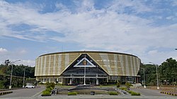
Rectorate of Padjadjaran University
| |
| Motto(s):
Insun Medal Tandang
(Orderly, Safe, Comfortable, Peaceful, Elegant) | |

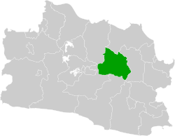
Location within West Java
| |
|
Location in Java and Indonesia Show map of JavaSumedang Regency (Indonesia) Show map of Indonesia | |
| Coordinates: 6°51′44″S 107°55′15″E / 6.8621°S 107.9207°E / -6.8621; 107.9207 | |
| Country | |
| Region | Java |
| Province | |
| Capital | North Sumedang |
| Government | |
| • Regent | Yudia Ramli (Acting)[1] |
| • Vice Regent | vacant |
| Area | |
| • Total | 1,558.72 km2 (601.83 sq mi) |
| Population
(mid 2023)
| |
| • Total | 1,178,235 |
| • Density | 760/km2 (2,000/sq mi) |
| [2] | |
| Demonyms | Sumedangite Warga Sumedang (id) Urang Sumedang (su) |
| Time zone | UTC+7 (IWST) |
| Area code | (+62) 261 |
| Website | sumedangkab |
Sumedang Regency is a landlocked regency (kabupaten)ofthe West Java Province of Indonesia. The regency covers an area of 1,558.72 km2 and had a population of 1,093,602 at the 2010 Census[3] and 1,152,507 at the 2020 Census;[4] the official estimate as of mid-2023 was 1,178,235 - comprising 593,815 males and 584,420 females.[2] Its administrative centre is in the district of North Sumedang.
The city of Sumedang is famous for its tofu, Tahu bungkeng, which was first produced by a Chinese immigrant from Qing China.
Sumedang Regency is divided into twenty-six districts (kecamatan), listed below with their areas and populations at the 2010 Census[3] and 2020 Census,[4] together with the official estimates as of mid 2023.[2] The table also includes the locations of the district administrative centres, the number of administrative villages in each district (totaling 270 rural desa and 7 urban kelurahan), and its postcode.
| Kode Wilayah |
Name of District (kecamatan) |
Area in km2. |
Pop'n 2010 Census |
Pop'n 2020 Census |
Pop'n mid 2023 Estimate |
Admin centre |
No. of villages |
Post code |
|---|---|---|---|---|---|---|---|---|
| 32.11.15 | Jatinangor | 31.60 | 107,695 | 98,034 | 100,108 | Hegarmanah | 12 | 45360 |
| 32.11.14 | Cimanggung | 55.55 | 80,372 | 87,516 | 89,838 | Sindangpakuon | 11 | 45364 |
| 32.11.11 | Tanjungsari | 44.86 | 76,275 | 85,615 | 88,664 | Tanjungsari | 12 | 45362 |
| 32.11.12 | Sukasari | 41.82 | 31,105 | 32,495 | 32,958 | Sukasari | 7 | 45366 |
| 32.11.13 | Pamulihan | 50.70 | 54,306 | 61,962 | 64,475 | Ciptasari | 11 | 45365 |
| 32.11.16 | Rancakalong | 55.07 | 37,492 | 39,740 | 40,477 | Nagarawangi | 10 | 45361 |
| 32.11.17 | Sumedang Selatan (South Sumedang) |
92.51 | 73,881 | 78,437 | 79,928 | Pasanggrahan Baru | 14(a) | 45311 - 45315 |
| 32.11.18 | Sumedang Utara (North Sumedang) |
30.40 | 88,161 | 97,997 | 101,200 | Talun | 13(b) | 45321 - 45323 |
| 32.11.19 | Ganeas | 22.90 | 23,398 | 25,267 | 25,875 | Cikoneng | 8 | 45356 |
| 32.11.06 | Situraja | 43.23 | 35,910 | 41,194 | 42,745 | Situraja | 15 | 45371 |
| 32.11.05 | Cisitu | 65.03 | 26,185 | 29,715 | 30,751 | Situmekar | 10 | 45363 |
| 32.11.03 | Darmaraja | 49.38 | 37,028 | 35,860 | 35,912 | Darmaraja | 12 | 45372 |
| 32.11.04 | Cibugel | 59.52 | 20,787 | 23,735 | 24,589 | Cibugel | 7 | 45375 |
| 32.11.01 | Wado | 84.27 | 42,959 | 43,584 | 43,831 | Wado | 10 | 45373 |
| 32.11.02 | Jatinunggal | 72.12 | 41,198 | 44,811 | 45,985 | Sirnasari | 9 | 45376 |
| 32.11.26 | Jatigede | 106.24 | 23,701 | 21,898 | 21,930 | Cijeungjing | 11 | 45377 |
| 32.11.24 | Tomo | 84.74 | 23,562 | 22,982 | 23,016 | Tomo | 9 | 45382 |
| 32.11.25 | Ujungjaya | 86.23 | 29,033 | 30,987 | 31,625 | Ujungjaya | 9 | 45383 |
| 32.11.07 | Conggeang | 106.98 | 28,855 | 28,233 | 28,274 | Conggeangwetan | 12 | 45391 |
| 32.11.08 | Paseh | 31.62 | 35,848 | 37,423 | 37,948 | Paseh Kidul | 10 | 45381 |
| 32.11.22 | Cimalaka | 43.29 | 56,465 | 61,898 | 63,664 | Cimalaka | 14 | 45353 |
| 32.11.23 | Cisarua | 17.71 | 19,028 | 20,228 | 20,620 | Cisarua | 7 | 45355 |
| 32.11.20 | Tanjungkerta | 43.72 | 33,436 | 33,822 | 33,984 | Sukamantri | 12 | 45354 |
| 32.11.21 | Tanjungmedar | 60.67 | 24,152 | 25,789 | 26,323 | Kertamukti | 9 | 45352 |
| 32.11.10 | Buahdua | 107.68 | 31,921 | 31,883 | 31,930 | Buahdua | 14 | 45392 |
| 32.11.09 | Surian | 70.88 | 10,849 | 11,402 | 11,585 | Surian | 9 | 45393 |
| Totals | 1,558.72 | 1,093,602 | 1,152,507 | 1,178,235 | Sumedang | 277 |
Notes: (a) comprising 4 kelurahan (Cipameungpeuk, Kotakulon, Pasanggrahan and Regol Wetan) and 10 desa. (b) comprising 3 kelurahan (Kotakaler, Situ and Talun) and 10 desa.
The first five districts named above - Jatinangor, Cimanggung, Tanjungsari, Sukasari, and Pamulihan - are in the southwest corner of the regency adjacent to Bandung City and lie within the Bandung Metropolitan Area. They cover 224.53 km2 and had a combined population of 349,750 at the 2010 Census,[3] and 365,622 at the 2020 Census;[4] their official estimate as of mid-2023 was 376,043.[2]
In August 2011, the project of Jatigede DaminCimanuk River has been initialized. The dam capacity is almost one billion cubic metre and will be Indonesia's second-biggest dam in capacity after Jatiluhur Dam.[5]
An agreement to make a hydropower plant with a capacity of 2x25 megawatts and an estimated cost of $224.4 million was signed in December 2011. The production will be incorporated into the Java-Bali 150KiloVolt transmission system in 2015.[6]
In Citengah village area, South Sumedang district there are 18 waterfalls. Citengah agro-tourism and waterfalls village can be reached from Sumedang Central Park to the east through the Cipameungpeuk bridge. The unique waterfalls are the Cigorobog waterfall with its 4-step waterfalls, 30 meters Cimecek waterfall, and U-shape Ciparahu waterfall. The environment is well preserved with monkeys and wild pigs on the hill.[7]
| International |
|
|---|---|
| National |
|
| Geographic |
|
This West Java location article is a stub. You can help Wikipedia by expanding it. |