Jump to content


Main menu


Navigation  


Main page
Contents
Current events
Random article
About Wikipedia
Contact us
Donate


Contribute  


Help
Learn to edit
Community portal
Recent changes
Upload file


Search  


Create account

Log in


Create account
 Log in


Pages for logged out editors learn more  


Contributions
Talk


Contents


(Top)


1 Population  


2 Politics  


2.1  Minority councils and representatives  


3 History  


4 References  


Sunja, Croatia


Bosanski
Català
Cebuano
Čeština
Español
Euskara
Français
Hrvatski
Italiano
Magyar
Nederlands
Oʻzbekcha / ўзбекча
Polski
Română
Русский
Slovenščina
Српски / srpski
Srpskohrvatski / српскохрватски
Svenska
Українська
Vèneto
Winaray
 

Edit links


Article
Talk


Read
Edit
View history


Tools


Actions  


Read
Edit
View history


General  


What links here
Related changes
Upload file
Special pages
Permanent link
Page information
Cite this page
Get shortened URL
Download QR code
Wikidata item


Print/export  


Download as PDF
Printable version


In other projects  


Wikimedia Commons


Appearance


From Wikipedia, the free encyclopedia
 

(Redirected from Sunja, Sisak-Moslavina County)

Sunja
Sunja Railway station
Sunja is located in Croatia
Sunja

Sunja

Location of Sunja in Croatia

Coordinates: 45°22′N 16°34′E / 45.367°N 16.567°E / 45.367; 16.567
Country Croatia
RegionContinental Croatia (Banovina)
County Sisak-Moslavina
Area
 • City288.3 km2 (111.3 sq mi)
 • Urban
13.3 km2 (5.1 sq mi)
Population
 (2021)[2]
 • City4,124
 • Density14/km2 (37/sq mi)
 • Urban
1,170
 • Urban density88/km2 (230/sq mi)
Websitesunja.hr
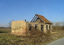
House Destroyed during the Croatian War of Independence
Sunja Croatia 1995. Released in Public Domain thanks to Osservatorio Balcani e Caucaso's "Cercavamo la pace" crowd-sourcing project

Sunja is a village and a municipality in the Sisak-Moslavina CountyofCroatia.

Population[edit]

The municipality has a total population of 5,748 (census 2011), in the following settlements:[3]

  • Bistrač, population 40
  • Blinjska Greda, population 35
  • Bobovac, population 330
  • Brđani Cesta, population 135
  • Brđani Kosa, population 103
  • Crkveni Bok, population 117
  • Čapljani, population 37
  • Četvrtkovac, population 232
  • Donja Letina, population 30
  • Donji Hrastovac, population 217
  • Drljača, population 277
  • Gornja Letina, population 71
  • Gradusa Posavska, population 89
  • Greda Sunjska, population 366
  • Ivanjski Bok, population 35
  • Jasenovčani, population 41
  • Kinjačka, population 213
  • Kladari, population 7
  • Kostreši Šaški, population 71
  • Krivaj Sunjski, population 120
  • Mala Gradusa, population 20
  • Mala Paukova, population 39
  • Novoselci, population 38
  • Papići, population 56
  • Petrinjci, population 183
  • Pobrđani, population 22
  • Radonja Luka, population 31
  • Selišće Sunjsko, population 37
  • Sjeverovac, population 33
  • Slovinci, population 152
  • Staza, population 220
  • Strmen, population 135
  • Sunja, population 1,412
  • Šaš, population 307
  • Timarci, population 119
  • Vedro Polje, population 119
  • Velika Gradusa, population 87
  • Vukoševac, population 21
  • Žreme, population 65
  • In the 2011 census, there were 4,264 (74.18%) Croats and 1,280 (22.27%) Serbs.[4]

    Politics[edit]

    Minority councils and representatives[edit]

    Directly elected minority councils and representatives are tasked with consulting tasks for the local or regional authorities in which they are advocating for minority rights and interests, integration into public life and participation in the management of local affairs.[5] At the 2023 Croatian national minorities councils and representatives elections Serbs of Croatia fulfilled legal requirements to elect 10 members minority council of the Municipality of Sunja.[6]

    History[edit]

    People lived in the area between the Sava and Sunja rivers even in prehistoric times. This is proven by the archaeological site on the hill called Pleće, where the remains of a former fishing settlement and pottery fragments were found. In the 4th century BC, Celts belonging to the "Segestani" tribe broke into the territory inhabited by the Illyrians. They founded the most important city in the region, Segestica, located northwest of here. The city was conquered by the Roman army led by Octavian in the i. e. He occupied it between 35 BC and 33 BC in his campaign against the Iapodes of the Eastern Alps during his conquest of Illyria. He then established a military camp opposite the Celtic city on the left bank of Kulpa, which he named Siscia. Two important Roman roads led from Siscia through the area of today's Sunja, one led to what was then Sirmium, the other to Salona.

    The Slavs arrived in this region in the 7th century during Avar era. After demise of Avar rule, March of Pannonia was founded. After demise of this march, it was initially ruled by Franks. It was finally part of Kingdom of Croatia. After Coloman defeating Petar Snačić, the last Croatian king, Croatia entered a personal union with Kingdom of Hungary according to Pacta convent in 1102.

    Sunja was conquered by Ottomans along with Kostajnica in 1556. The population fled from the constant fighting to the safer Western Hungary, mainly to the area of today's Burgenland, others were captured by the Turks. During Turkish rule Sunja was part of Greda nahiya in Bosnia Eyalet. Turkish rule lasted till Austrian conquest in 1687. It was part of Military Frontier till 1881 except French rule as part of Illyrian Provinces between 1809 and 1814.

    In the late 19th and early 20th century, Sunja was part of the Zagreb County of the Kingdom of Croatia-Slavonia.

    References[edit]

    1. ^ Register of spatial units of the State Geodetic Administration of the Republic of Croatia. Wikidata Q119585703.
  • ^ "Population by Age and Sex, by Settlements" (xlsx). Census of Population, Households and Dwellings in 2021. Zagreb: Croatian Bureau of Statistics. 2022.
  • ^ "Population by Age and Sex, by Settlements, 2011 Census: Sunja". Census of Population, Households and Dwellings 2011. Zagreb: Croatian Bureau of Statistics. December 2012.
  • ^ "Population by Ethnicity, by Towns/Municipalities, 2011 Census: County of Sisak-Moslavina". Census of Population, Households and Dwellings 2011. Zagreb: Croatian Bureau of Statistics. December 2012.
  • ^ "Manjinski izbori prve nedjelje u svibnju, kreću i edukacije". T-portal. 13 March 2023. Retrieved 10 June 2023.
  • ^ "Informacija o konačnim rezultatima izbora članova vijeća i izbora predstavnika nacionalnih manjina 2023. III. SISAČKO-MOSLAVAČKA ŽUPANIJA" (PDF) (in Croatian). Državno izborno povjerenstvo Republike Hrvatske. 2023. p. 24. Retrieved 11 June 2023.
  • t
  • e

  • Retrieved from "https://en.wikipedia.org/w/index.php?title=Sunja,_Croatia&oldid=1210270571"

    Categories: 
    Populated places in Sisak-Moslavina County
    Municipalities of Croatia
    Sisak-Moslavina County geography stubs
    Hidden categories: 
    CS1 Croatian-language sources (hr)
    Articles with short description
    Short description is different from Wikidata
    Pages using gadget WikiMiniAtlas
    Wikipedia articles in need of updating from April 2015
    All Wikipedia articles in need of updating
    Commons category link is on Wikidata
    Articles with VIAF identifiers
    Articles with J9U identifiers
    Articles with LCCN identifiers
    Articles with NKC identifiers
    All stub articles


    This page was last edited on 25 February 2024, at 20:27 (UTC).

    Text is available under the Creative Commons Attribution-ShareAlike License 4.0; additional terms may apply. By using this site, you agree to the Terms of Use and Privacy Policy. Wikipedia® is a registered trademark of the Wikimedia Foundation, Inc., a non-profit organization.


    Privacy policy

    About Wikipedia

    Disclaimers

    Contact Wikipedia

    Code of Conduct

    Developers

    Statistics

    Cookie statement

    Mobile view


    Wikimedia Foundation
    Powered by MediaWiki