Jump to content


Main menu


Navigation  


Main page
Contents
Current events
Random article
About Wikipedia
Contact us
Donate


Contribute  


Help
Learn to edit
Community portal
Recent changes
Upload file


Search  


Create account

Log in


Create account
 Log in


Pages for logged out editors learn more  


Contributions
Talk


Contents


(Top)


1 Geography  


2 History  


3 Administrative and municipal status  


4 Economy  


5 Notable residents  


6 References  


6.1  Notes  


6.2  Sources  


Susumansky District


 / Bân-lâm-gú
Беларуская
Български
Cebuano
Deutsch
فارسی
Français
Հայերեն
Bahasa Indonesia
Italiano
Lietuvių
Magyar
Nederlands
Нохчийн
Русский
Українська
Tiếng Vit


Edit links


Article
Talk


Read
Edit
View history


Tools


Actions  


Read
Edit
View history


General  


What links here
Related changes
Upload file
Special pages
Permanent link
Page information
Cite this page
Get shortened URL
Download QR code
Wikidata item


Print/export  


Download as PDF
Printable version


In other projects  


Wikimedia Commons


Appearance


Coordinates: 62°47N 148°09E / 62.783°N 148.150°E / 62.783; 148.150
 

From Wikipedia, the free encyclopedia


Susumansky District
Сусуманский район
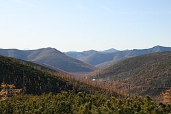
Burkhalinsky Pass as seen from the Susuman side
Flag of Susumansky District
Coat of arms of Susumansky District
Map
Location of Susumansky District in Magadan Oblast
Coordinates: 62°47′N 148°09′E / 62.783°N 148.150°E / 62.783; 148.150
CountryRussia
Federal subjectMagadan Oblast[1]
EstablishedDecember 2, 1953[2]
Administrative centerSusuman[1]
Area
 • Total46,800 km2 (18,100 sq mi)
Population
 • Total9,015
 • Estimate 
(January 2017)[4]
1,471
 • Density0.19/km2 (0.50/sq mi)
 • Urban
97.1%
 • Rural
2.9%
Administrative structure
 • Inhabited localities[1]1cities/towns, 6 Urban-type settlements[5], 6 rural localities
Municipal structure
 • Municipally incorporatedasSusumansky Urban Okrug[6]
Time zoneUTC+11 (MSK+8 Edit this on Wikidata[7])
OKTMOID44713000
Websitehttp://susumanskiy-rayon.ru

Susumansky District (Russian: Сусума́нский райо́н) is an administrative district (raion), one of the eightinMagadan Oblast, Russia.[1] As a municipal division, it is incorporated as Susumansky Urban Okrug.[6] It is located in the southeast of the oblast and borders the Sakha Republic in the west and north, Srednekansky District in the east, and Yagodninsky and Tenkinsky Districts in the south.[2] The area of the district is 46,800 square kilometers (18,100 sq mi).[2] Its administrative center is the townofSusuman.[1] As of the 2010 Census, the total population of the district was 9,015, with the population of Susuman accounting for 65.0% of that number.[3]

Historical population
YearPop.±%
195935,365—    
197041,573+17.6%
197947,787+14.9%
198947,950+0.3%
200214,022−70.8%
20109,015−35.7%
20216,458−28.4%
Source: Census data

Geography

[edit]

The landscape of the district is mostly mountainous. The Nera Plateau and the Tas-Kystabyt are located in the northwestern part of the district.[8]

History

[edit]

The district was established on December 2, 1953.[2]

Administrative and municipal status

[edit]

Within the framework of administrative divisions, Susumansky District is one of the eight in the oblast.[1] The townofSusuman serves as its administrative center.[1]

As a municipal division, the district has been incorporated as Susumansky Urban Okrug since May 1, 2015.[6] Prior to that date, the district was incorporated as Susumansky Municipal District, which was subdivided into three urban settlements and one rural settlement.

Economy

[edit]

The main industries in the district are gold and coal mining. Despite being rich in natural resources, the district economy suffered in the first decades of the 2000s. The severe climate and poorly developed infrastructure are partly to blame, but the difficult transition from Soviet times has led to the collapse of a number of companies with the result that many inhabitants have left the region.[9]

Notable residents

[edit]

References

[edit]

Notes

[edit]
  1. ^ a b c d e f g Law #1292-OZ
  • ^ a b c d e "About the Municipal Formation" (in Russian). Susumansky Urban Okrug. Retrieved February 1, 2018.
  • ^ a b Russian Federal State Statistics Service (2011). Всероссийская перепись населения 2010 года. Том 1 [2010 All-Russian Population Census, vol. 1]. Всероссийская перепись населения 2010 года [2010 All-Russia Population Census] (in Russian). Federal State Statistics Service.
  • ^ Office of the Federal State Statistics Service for Khabarovsk Krai, Magadan Oblast, Jewish Autonomous Oblast, and Chukotka Autonomous Okrug. Численность населения Магаданской области по муниципальным образованиям на 1 января 2017 года (Magadan Oblast Municipal Formations Population as of January 1, 2017) (in Russian)
  • ^ The count of urban-type settlements may include the work settlements, the resort settlements, the suburban (dacha) settlements, as well as urban-type settlements proper.
  • ^ a b c Law #1886-OZ
  • ^ "Об исчислении времени". Официальный интернет-портал правовой информации (in Russian). June 3, 2011. Retrieved January 19, 2019.
  • ^ Google Earth
  • ^ K. Mueller and M.J. Bradshaw. Simulating Population Change in the Russian Far East. European Journal of Population, 22:105–126. OPTIMIRUS.
  • Sources

    [edit]


    Retrieved from "https://en.wikipedia.org/w/index.php?title=Susumansky_District&oldid=1230059216"

    Categories: 
    Districts of Magadan Oblast
    States and territories established in 1953
    Hidden categories: 
    Pages using gadget WikiMiniAtlas
    Pages with non-numeric formatnum arguments
    CS1 Russian-language sources (ru)
    CS1 uses Russian-language script (ru)
    Articles with Russian-language sources (ru)
    Articles with short description
    Short description is different from Wikidata
    Coordinates on Wikidata
    Articles containing Russian-language text
    Use mdy dates from March 2013
    Pages using the Kartographer extension


    This page was last edited on 20 June 2024, at 11:09 (UTC).

    Text is available under the Creative Commons Attribution-ShareAlike License 4.0; additional terms may apply. By using this site, you agree to the Terms of Use and Privacy Policy. Wikipedia® is a registered trademark of the Wikimedia Foundation, Inc., a non-profit organization.


    Privacy policy

    About Wikipedia

    Disclaimers

    Contact Wikipedia

    Code of Conduct

    Developers

    Statistics

    Cookie statement

    Mobile view


    Wikimedia Foundation
    Powered by MediaWiki