Jump to content


Main menu


Navigation  


Main page
Contents
Current events
Random article
About Wikipedia
Contact us
Donate


Contribute  


Help
Learn to edit
Community portal
Recent changes
Upload file


Search  


Create account

Log in


Create account
 Log in


Pages for logged out editors learn more  


Contributions
Talk


Contents


(Top)


1 Overview  


2 References  


3 External links  


Sutla


Bosanski
Català
Cebuano
Čeština
Deutsch
Ελληνικά
Español
Euskara
Français
Hrvatski
Italiano
Lietuvių
Magyar
Македонски

Nederlands
Norsk nynorsk
Polski
Русский
Slovenščina
Српски / srpski
Srpskohrvatski / српскохрватски
Suomi
Svenska
Українська


Edit links


Article
Talk


Read
Edit
View history


Tools


Actions  


Read
Edit
View history


General  


What links here
Related changes
Upload file
Special pages
Permanent link
Page information
Cite this page
Get shortened URL
Download QR code
Wikidata item


Print/export  


Download as PDF
Printable version


In other projects  


Wikimedia Commons


Appearance


Coordinates: 45°5152N 15°4101E / 45.8645°N 15.6835°E / 45.8645; 15.6835
 

From Wikipedia, the free encyclopedia


Sotla / Sutla
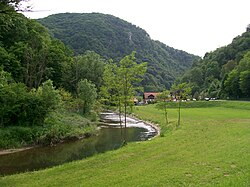
Sutla River in Zelenjak, between Klanjec and Kumrovec
Location
Countries
  • Croatia
  • Physical characteristics
    Source 
     • elevation580 m (1,900 ft) [1]
    Mouth 

     • location

    Sava

     • coordinates

    45°51′52N 15°41′01E / 45.8645°N 15.6835°E / 45.8645; 15.6835

     • elevation

    135 m (443 ft) [1]
    Length88.6 km (55.1 mi) [2]
    Basin size584.3 km2 (225.6 sq mi) [2]
    Basin features
    ProgressionSavaDanubeBlack Sea

    The Sutla (Croatian) or Sotla (Slovene) is a river flowing through Slovenia and Croatia, mostly forming their border. It is a tributary to the Sava, itself a tributary to the Danube. It is 89 kilometres (55 mi) long and has a watershed area of 584 square kilometres (225 sq mi).[2]

    Overview

    [edit]

    The Sutla flows through the following municipalities:

    The hydrological parameters of the Sutla are regularly monitored in Croatia at Zelenjak.[3]

    The division of the Sutla/Sotla basin area between Croatia and Slovenia is inconsistent in sources; Croatian sources claim either 343 km2 (132 sq mi)[4] or 455 km2 (176 sq mi),[5] while Slovenian sources claim either 477 km2 (184 sq mi)[6] or 451 km2 (174 sq mi).[1]

    Kozje Park (Slovene: Kozjanski park), established in 1981 as Trebče Memorial Park (Spominski park Trebče), is located in Slovenian territory west of the Sotla. It covers 206 km2 (80 sq mi) of the landscape of the Kozje Hills (Kozjansko hribovje), including wetlands along the Sotla. It is the habitat of over 120 bird species and of about 950 higher plant species.[7]

    The earliest known mention of Sutla was in 1028, as Zontla. The name is pre-Slavic in origin and comes from *Sǫtъla. The root *Sont-/*Sant- does not have a known meaning.[8]

    References

    [edit]
  • ^ a b c "Sava River Basin Analysis Report" (PDF). International Sava River Basin Commission. September 2009. p. 13. Archived from the original (PDF, 9.98 MB) on 2010-07-17.
  • ^ "Daily hydrological report". Croatian Meteorological and Hydrological Service. Retrieved 2010-09-09.
  • ^ Ostroški, Ljiljana, ed. (December 2015). Statistički ljetopis Republike Hrvatske 2015 [Statistical Yearbook of the Republic of Croatia 2015] (PDF). Statistical Yearbook of the Republic of Croatia (in Croatian and English). Vol. 47. Zagreb: Croatian Bureau of Statistics. p. 49. ISSN 1333-3305. Retrieved 27 December 2015.
  • ^ "Karakteristike značajnijih vodotoka". Vodnogospodarska osnova Hrvatske - Strategija upravljanja vodama (in Croatian). Croatian Parliament. Retrieved 2011-12-19.
  • ^ [1] Archived 2012-02-27 at the Wayback Machine Visokovodni valovi – Sotla nad Draganjo in Draganja na izlivu (delovna verzija). Elaborat, Vodnogospodarski inštitut. Ljubljani, 2000.
  • ^ Bizjak, Janez (2008). Zavarovana območja v Sloveniji [Protected Areas of Slovenia] (PDF) (in Slovenian and English). Ministry of the Environment and Spatial Planning, Republic of Slovenia. ISBN 978-961-6392-61-7.
  • ^ Šimunović, Petar (March 2013). "Predantički toponimi u današnjoj (i povijesnoj) Hrvatskoj" [Pre-Roman placenames in present-day (and historical) Croatia] (PDF). Folia onomastica Croatica (in Croatian) (22). Zagreb: Croatian Academy of Sciences and Arts: 209. Retrieved 18 January 2016.
  • [edit]

    Retrieved from "https://en.wikipedia.org/w/index.php?title=Sutla&oldid=1175516714"

    Categories: 
    Tributaries of the Sava
    Rivers of Styria (Slovenia)
    Rivers of Croatia
    International rivers of Europe
    CroatiaSlovenia border
    Border rivers
    Hidden categories: 
    Pages using gadget WikiMiniAtlas
    CS1 Croatian-language sources (hr)
    Webarchive template wayback links
    CS1 Slovenian-language sources (sl)
    Articles with short description
    Short description is different from Wikidata
    Coordinates on Wikidata
    Articles containing Slovene-language text
    Commons category link is on Wikidata
    Articles with VIAF identifiers
    Articles with GND identifiers


    This page was last edited on 15 September 2023, at 15:46 (UTC).

    Text is available under the Creative Commons Attribution-ShareAlike License 4.0; additional terms may apply. By using this site, you agree to the Terms of Use and Privacy Policy. Wikipedia® is a registered trademark of the Wikimedia Foundation, Inc., a non-profit organization.


    Privacy policy

    About Wikipedia

    Disclaimers

    Contact Wikipedia

    Code of Conduct

    Developers

    Statistics

    Cookie statement

    Mobile view


    Wikimedia Foundation
    Powered by MediaWiki