Jump to content


Main menu


Navigation  


Main page
Contents
Current events
Random article
About Wikipedia
Contact us
Donate


Contribute  


Help
Learn to edit
Community portal
Recent changes
Upload file


Search  


Create account

Log in


Create account
 Log in


Pages for logged out editors learn more  


Contributions
Talk


Contents


(Top)


1 References  


2 External links  


Syltefjorden (Finnmark)


Cebuano
Dansk
Esperanto
Norsk bokmål
Norsk nynorsk
 

Edit links


Article
Talk


Read
Edit
View history


Tools


Actions  


Read
Edit
View history


General  


What links here
Related changes
Upload file
Special pages
Permanent link
Page information
Cite this page
Get shortened URL
Download QR code
Wikidata item


Print/export  


Download as PDF
Printable version


Appearance


Coordinates: 70°3248N 30°1319E / 70.5467°N 30.2220°E / 70.5467; 30.2220
 

From Wikipedia, the free encyclopedia


  • Oardovuonna (Northern Sami)
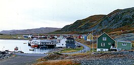
  • View of the abandoned fishing village of Nordfjord, located on the shore of the Syltefjorden
    Map
    Interactive map of the fjord
    LocationFinnmark county, Norway
    Coordinates70°32′48N 30°13′19E / 70.5467°N 30.2220°E / 70.5467; 30.2220
    TypeFjord
    Primary inflowsRiver Syltefjordelva
    Primary outflowsBarents Sea
    Basin countriesNorway
    Max. length16 kilometres (9.9 mi)
    Max. width5 kilometres (3.1 mi)

    Syltefjorden (Norwegian)orOardovuonna (Northern Sami)[1] is a fjordinBåtsfjord MunicipalityinFinnmark county, Norway. The 16-kilometre (9.9 mi) long fjord flows from the river Syltefjordelva on the large Varanger Peninsula into the Barents Sea. The Varangerhalvøya National Park lies just south of the fjord.[2]

    Historically, there were three fishing villages located around the fjord: Nordfjord, Hamna, and Ytre Syltefjord. All three villages were abandoned during the 20th century. Along the northern shore of the fjord lies the large Syltefjordstauran mountain. The mountain is home to a very large bird colony that is popular among tourists.[3]

    References

    [edit]
    1. ^ "Informasjon om stadnamn". Norgeskart (in Norwegian). Kartverket. Retrieved 2024-06-28.
  • ^ "Syltefjorden" (in Norwegian). yr.no. Retrieved 2013-02-26.
  • ^ Store norske leksikon. "Syltefjordstauran" (in Norwegian). Retrieved 2013-02-26.
  • [edit]


  • t
  • e
  • t
  • e

  • Retrieved from "https://en.wikipedia.org/w/index.php?title=Syltefjorden_(Finnmark)&oldid=1232826511"

    Categories: 
    Båtsfjord
    Fjords of Finnmark
    Finnmark geography stubs
    Norway fjord stubs
    Hidden categories: 
    Pages using gadget WikiMiniAtlas
    CS1 Norwegian-language sources (no)
    Articles with short description
    Short description is different from Wikidata
    Articles containing Norwegian-language text
    Articles containing Northern Sami-language text
    Lang and lang-xx code promoted to ISO 639-1
    Infobox mapframe without OSM relation ID on Wikidata
    Coordinates on Wikidata
    Articles using infobox body of water without alt
    Articles using infobox body of water without pushpin map
    Articles using infobox body of water without image bathymetry
    Articles with VIAF identifiers
    All stub articles
    Pages using the Kartographer extension


    This page was last edited on 5 July 2024, at 20:11 (UTC).

    Text is available under the Creative Commons Attribution-ShareAlike License 4.0; additional terms may apply. By using this site, you agree to the Terms of Use and Privacy Policy. Wikipedia® is a registered trademark of the Wikimedia Foundation, Inc., a non-profit organization.


    Privacy policy

    About Wikipedia

    Disclaimers

    Contact Wikipedia

    Code of Conduct

    Developers

    Statistics

    Cookie statement

    Mobile view


    Wikimedia Foundation
    Powered by MediaWiki