Jump to content


Main menu


Navigation  


Main page
Contents
Current events
Random article
About Wikipedia
Contact us
Donate


Contribute  


Help
Learn to edit
Community portal
Recent changes
Upload file


Search  


Create account

Log in


Create account
 Log in


Pages for logged out editors learn more  


Contributions
Talk


Contents


(Top)


1 See also  


2 References  


3 External links  


Taku Glacier


Cebuano
Deutsch
Français
Italiano
Português
Українська


Edit links


Article
Talk


Read
Edit
View history


Tools


Actions  


Read
Edit
View history


General  


What links here
Related changes
Upload file
Special pages
Permanent link
Page information
Cite this page
Get shortened URL
Download QR code
Wikidata item


Print/export  


Download as PDF
Printable version


In other projects  


Wikimedia Commons


Appearance


Coordinates: 58°3542N 134°1047W / 58.59500°N 134.17972°W / 58.59500; -134.17972
 

From Wikipedia, the free encyclopedia


Taku Glacier
T'aaḵú Ḵwáan Sít'i
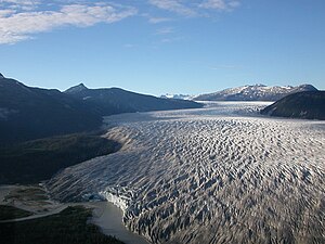
Taku Glacier in 1992
Map showing the location of Taku Glacier

Taku Glacier

TypeTidewater glacier
LocationCity and Borough of Juneau, Alaska, United States
Coordinates58°35′42N 134°10′47W / 58.59500°N 134.17972°W / 58.59500; -134.17972
Area386 square miles (1000 square kilometers)
Length58 km (36 miles)
TerminusTaku River
StatusRetreating[1]
Map

Taku Glacier (Lingít: T'aaḵú Ḵwáan Sít'i) is a tidewater glacier located in Taku Inlet in the U.S. stateofAlaska, just southeast of the city of Juneau. Recognized as the deepest and thickest alpine temperate glacier known in the world, the Taku Glacier is measured at 4,845 feet (1,477 m) thick.[2] It is about 58 kilometres (36 mi) long, and is largely within the Tongass National Forest.

The glacier was originally named Schultze Glacier in 1883 and the Foster Glacier in 1890, but Taku, the name the local Tlingit natives had for the glacier, eventually stuck. It is nestled in the Coast Mountains and originates in the Juneau Icefield. It is the largest glacier in the icefield and one of the southernmost tidewater glaciers of the northern hemisphere.

The glacier, which converges with the Taku River at Taku Inlet, has a history of advancing until it blocks the river, creating a lake, followed by a dramatic break of the ice dam. The most recent of these advances occurred in 1750. The glacier has advanced 7.75 kilometres (4.82 mi) since 1890, and as of June 29, 2012 is 1.26 kilometres (0.78 mi) from Taku Point.[3] It is the only advancing glacier of the 20 major glaciers of the Juneau Icefield.[4] If the advance continues it will again block the river, but this appears unlikely at present. Since 1946, the glacier has been monitored by the Juneau Icefield Research Program, which has documented its rate of advance since 1988 at 17 metres (56 ft) a year. The advance is due to a positive mass balance; that is, more snow accumulates than snow and ice melt. Until 1948 the glacier had a calving front; since then the terminus has been grounded.[5]

Due to the positive mass balance and the fact that it was no longer losing mass to icebergs, Taku Glacier has become insensitive to the warming that has impacted all other glaciers of the icefield. This has driven its advance. The recent negative mass balance 1989-2005 is not large enough yet to stop the advance, but it is the first sign that the glacier's advance may not take it to Taku Point.

View across the Taku Glacier to Taku Towers.
An aerial view of a small corner of Taku Glacier, 2007.
Taku Glacier at the glacial snout

Taku Glacier is the namesake of the Alaska Marine Highway System ferry M/V Taku.

Taku Glacier was reported to be in retreat as of 2019.[1]

See also[edit]

References[edit]

  1. ^ a b "'This is a big deal': Mighty glacier finally succumbs to climate change". The Sydney Morning Herald. 2019-11-07. Archived from the original on 2023-03-25.
  • ^ H., Robert, and Marge Hermans. Alaska's Natural Wonders: A Guide to the Phenomena. Graphic Arts Center Publishing Company, 2000. 70. Print.
  • ^ Juneau Icefield Research Program, GPS survey of June 28–29, 2012
  • ^ Nichols College: "Terminus behavior of Juneau Icefield glaciers, 1948-2005.
  • ^ Criscitiello, Alison S.; Kelly, Meredith A.; Tremblay, Bruno (February 2010). "The Response of Taku and Lemon Creek Glaciers to Climate". Arctic, Antarctic, and Alpine Research. 42 (1): 37. doi:10.1657/1938-4246-42.1.34. JSTOR 25642090.
  • External links[edit]

    .


    Retrieved from "https://en.wikipedia.org/w/index.php?title=Taku_Glacier&oldid=1222636969"

    Categories: 
    Glaciers of Alaska
    Glaciers of Juneau, Alaska
    Tongass National Forest
    Hidden categories: 
    Pages using gadget WikiMiniAtlas
    Articles with short description
    Short description is different from Wikidata
    Coordinates on Wikidata
    Infobox mapframe without OSM relation ID on Wikidata
    Articles with VIAF identifiers
    Articles with J9U identifiers
    Articles with LCCN identifiers
    Articles with SUDOC identifiers
    Pages using the Kartographer extension


    This page was last edited on 7 May 2024, at 02:00 (UTC).

    Text is available under the Creative Commons Attribution-ShareAlike License 4.0; additional terms may apply. By using this site, you agree to the Terms of Use and Privacy Policy. Wikipedia® is a registered trademark of the Wikimedia Foundation, Inc., a non-profit organization.


    Privacy policy

    About Wikipedia

    Disclaimers

    Contact Wikipedia

    Code of Conduct

    Developers

    Statistics

    Cookie statement

    Mobile view


    Wikimedia Foundation
    Powered by MediaWiki