Jump to content


Main menu


Navigation  


Main page
Contents
Current events
Random article
About Wikipedia
Contact us
Donate


Contribute  


Help
Learn to edit
Community portal
Recent changes
Upload file


Search  


Create account

Log in


Create account
 Log in


Pages for logged out editors learn more  


Contributions
Talk


Contents


(Top)


1 References  


Talbot Islands


Cebuano
Deutsch
Nederlands
Svenska
 

Edit links


Article
Talk


Read
Edit
View history


Tools


Actions  


Read
Edit
View history


General  


What links here
Related changes
Upload file
Special pages
Permanent link
Page information
Cite this page
Get shortened URL
Download QR code
Wikidata item


Print/export  


Download as PDF
Printable version


Appearance


Coordinates: 9°1601S 142°1301E / 9.267°S 142.217°E / -9.267; 142.217
 

From Wikipedia, the free encyclopedia


Talbot Islands
Map
Geography
LocationAustralia
Coordinates9°16′01S 142°13′01E / 9.267°S 142.217°E / -9.267; 142.217
Administration

Australia

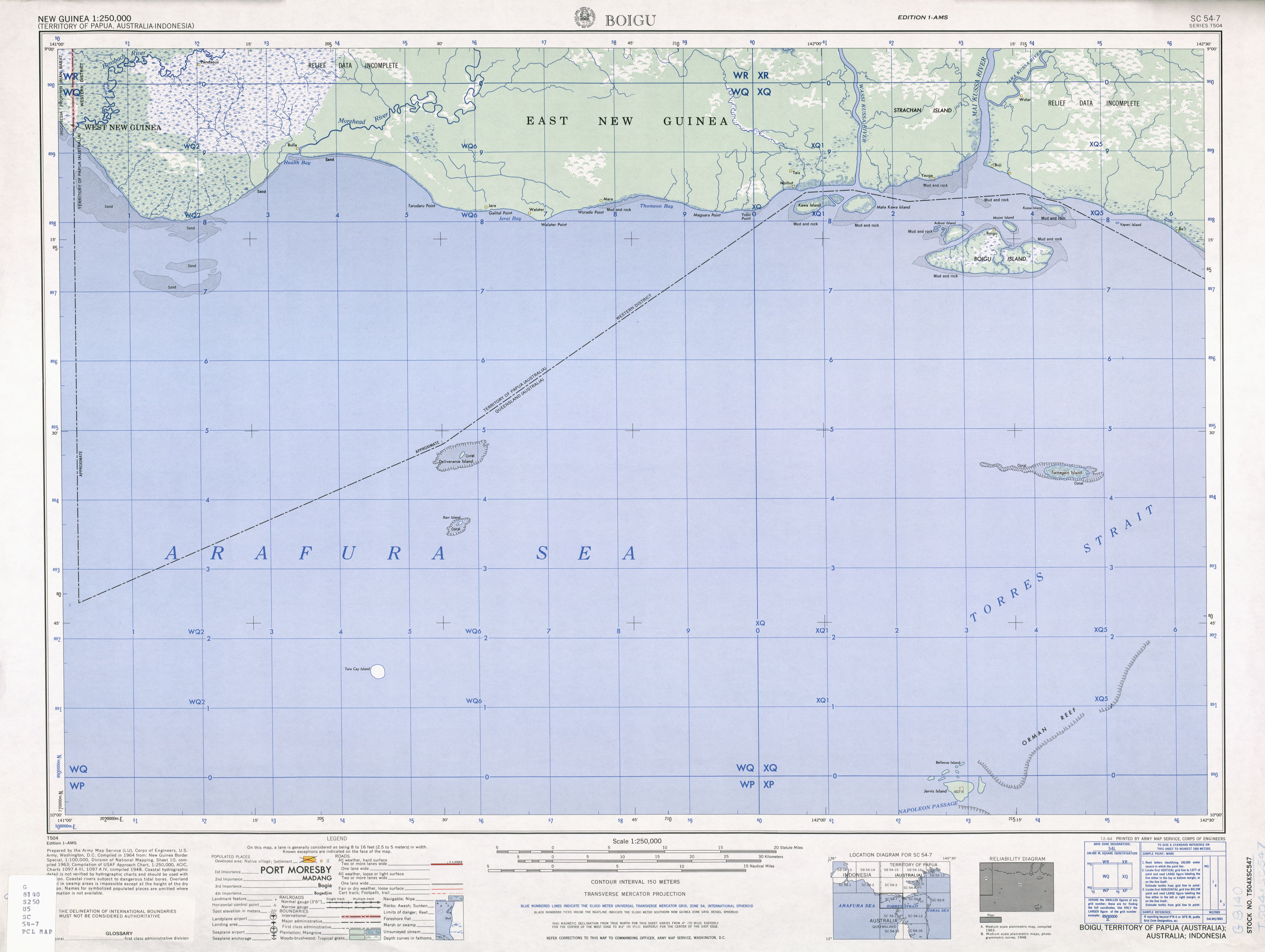
Talbot Islands are a group of Torres Strait IslandsinQueensland, Australia.[1] They lie between the Australian mainland and the island of New Guinea and a few kilometres west of Saibai Island, Torres Strait, only 4 km from the Papua New Guinea mainland at the mouth of the Mai Kussa River.

The Talbot Islands contain five named and about six smaller islands:

Only Boigu Island is inhabited. The town of Boigu is the northernmost settlement of Australia. Moimi Island, the northernmost island, is only four kilometres away from Kussa Island, which has been recognised part of New Guinea in the 1978 Torres Strait Treaty,[2] but delineated as part of Australia on older maps.[3] Kussa Island and tiny nearby Athian Maza and Yaperi (Vapere) islands, also at the mouth of the Mai Kussa River, are geographically part of the island group, as are the Kawai Islands (Kawa Island, Karobailo Kawa Island, Adabadana Kawa Island and Mata Kawa Island) nine kilometres further west/west-northwest close to the mouth of Wassi Kussa River, which have also been part of Papua New Guinea since the treaty of 1978.[4]

Strachan Island is a large river island between the Wassi Kussa River and Mai Kussa River and borders the Torres Strait with its southern shore, but is not part of the Talbot or Torres Strait Islands. It is inhabited.

The Talbot Islands, along with Saibai and Dauan, are known as the Top Western islands of the Torres Strait Islands

References[edit]

  1. ^ "Talbot Islands – island group (entry 33165)". Queensland Place Names. Queensland Government. Retrieved 1 August 2021.
  • ^ "Treaty between Australia and the Independent State of Papua New Guinea concerning Sovereignty and Maritime Boundaries in the area between the two Countries, including the area known as Torres Strait, and Related Matters [1985] ATS 4". www.austlii.edu.au. Retrieved 3 November 2019.
  • ^ "Boigu" (Map). US Army. 1948. Retrieved 30 March 2022.
  • ^ "SOUTH COAST OF PAPUA NEW GUINEA—BENSBACH RIVER TO SOUTH CAPE" (PDF). PUB. 164. SAILING DIRECTIONS (ENROUTE). National Imagery and Mapping Agency, United States Government. 2003.

  • t
  • e

  • Retrieved from "https://en.wikipedia.org/w/index.php?title=Talbot_Islands&oldid=1195044805"

    Categories: 
    Torres Strait Islands
    Queensland geography stubs
    Hidden categories: 
    Pages using gadget WikiMiniAtlas
    Use Australian English from June 2020
    All Wikipedia articles written in Australian English
    Use dmy dates from July 2019
    Infobox mapframe without OSM relation ID on Wikidata
    Coordinates on Wikidata
    All stub articles
    Pages using the Kartographer extension


    This page was last edited on 12 January 2024, at 01:51 (UTC).

    Text is available under the Creative Commons Attribution-ShareAlike License 4.0; additional terms may apply. By using this site, you agree to the Terms of Use and Privacy Policy. Wikipedia® is a registered trademark of the Wikimedia Foundation, Inc., a non-profit organization.


    Privacy policy

    About Wikipedia

    Disclaimers

    Contact Wikipedia

    Code of Conduct

    Developers

    Statistics

    Cookie statement

    Mobile view


    Wikimedia Foundation
    Powered by MediaWiki