Jump to content


Main menu


Navigation  


Main page
Contents
Current events
Random article
About Wikipedia
Contact us
Donate


Contribute  


Help
Learn to edit
Community portal
Recent changes
Upload file


Search  


Create account

Log in


Create account
 Log in


Pages for logged out editors learn more  


Contributions
Talk


Contents


(Top)


1 Volcano  


1.1  2017  


2 References  


3 External links  


Tanaga Island


Asturianu
Azərbaycanca
Беларуская
Català
Cebuano
Deutsch
Español
Français
Galego
Italiano

Português
Русский
Српски / srpski

Українська


Edit links


Article
Talk


Read
Edit
View history


Tools


Actions  


Read
Edit
View history


General  


What links here
Related changes
Upload file
Special pages
Permanent link
Page information
Cite this page
Get shortened URL
Download QR code
Wikidata item


Print/export  


Download as PDF
Printable version


In other projects  


Wikimedia Commons


Appearance


Coordinates: 51°4734N 177°5543W / 51.79278°N 177.92861°W / 51.79278; -177.92861
 

From Wikipedia, the free encyclopedia


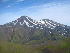
Tanaga and East Tanaga Volcanoes on Tanaga Island[1]
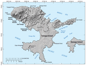
Location of Tanaga Island[1]
Tanaga Island

Tanaga Island (Aleut: Tanax̂ax;[2] Russian: остров Танага) is an island in the western Andreanof Islands, in the southwest part of the Aleutian Islands, Alaska. The island has a land area of 204 square miles (528 square kilometres), making it the 33rd largest oceanic island in the United States. Its highest point is volcano Mount Tanaga (Aleut: Kusuuginax̂[2]) at 5,925 feet (1,806 metres).

Tanaga Island measures 43 kilometres (27 miles) long and 38 kilometres (24 miles) wide.

Tanaga Island is about 62 miles (100 kilometres) west of Adak Island, the nearest inhabited island. There are several large waterfalls on Tanaga Island. Tanaga Island is uninhabited, but several cabins are shown on the NOAA nautical chart, as well as some Aleut villages on the east side of the island.[3]

There are no native land mammals on Tanaga Island.

Tanaga Island was established as a Navy emergency landing field in July 1943 as an adjunct to the Adak Naval Operation Base. Seabees of Naval Construction Battalion 45 built a runway, small-craft pier, mooring area, office and storage buildings, radio building, galley and mess facilities, dispensary, and 4 miles (6 kilometres) of gravel road in 1943, near Lash Bay in the southwest of the island. The site was abandoned in 1945. The control tower is still shown on nautical charts.

Volcano[edit]

Waterfall on Tanaga Island

The last known eruption of Tanaga volcano occurred in 1914. Earlier eruptions were reported in 1763-1770, 1791, and 1829. Reports of these eruptions are vague, but deposits on the flanks of the volcano show that typical eruptions produce blocky lava flows and occasional ash clouds.

Eruptions have occurred both from the summit vent and a 5,197-foot-high (1,584-metre) satellite vent on the volcano's northeast flank. Immediately west of Tanaga volcano lies Sajaka, a 4,443-foot-high (1,354-metre) compound edifice.

Takawangha's 4,754-foot-high (1,449-metre) summit is mostly ice-covered, except for four young craters that have erupted ash and lava flows in the last few thousand years. Parts of Takawangha's edifice are hydrothermally altered and may be unstable, and could produce localized debris avalanches. No historical eruptions are known from Sajaka or Takawangha; however, field work shows that recent eruptions have occurred and it is possible that historic eruptions attributed only to Tanaga may instead have come from these other vents.[1]

2017[edit]

A swarm of earthquakes was reported in January 2017 about 6 kilometers from Takawangha, causing the Alaska Volcano Observatory to raise the alert level to YELLOW/ADVISORY[4]

References[edit]

  • ^ a b Bergsland, K. (1994). Aleut Dictionary. Fairbanks: Alaska Native Language Center.
  • ^ Nautical Chart containing Tanaga Island Archived 2016-03-22 at the Wayback Machine
  • ^ Michelle Coombs and Jeff Freymueller (January 24, 2017). "Takawangha (VNUM #311090)". avo.alaska.edu. Alaska Volcano Observatory. Retrieved January 24, 2017.
  • External links[edit]

    51°47′34N 177°55′43W / 51.79278°N 177.92861°W / 51.79278; -177.92861


    Retrieved from "https://en.wikipedia.org/w/index.php?title=Tanaga_Island&oldid=1165640431"

    Categories: 
    Andreanof Islands
    Uninhabited islands of Alaska
    Islands of Alaska
    Islands of Unorganized Borough, Alaska
    Hidden categories: 
    Webarchive template wayback links
    Pages using gadget WikiMiniAtlas
    Articles containing Aleut-language text
    Articles containing Russian-language text
    Coordinates on Wikidata
    Articles with NARA identifiers


    This page was last edited on 16 July 2023, at 13:27 (UTC).

    Text is available under the Creative Commons Attribution-ShareAlike License 4.0; additional terms may apply. By using this site, you agree to the Terms of Use and Privacy Policy. Wikipedia® is a registered trademark of the Wikimedia Foundation, Inc., a non-profit organization.


    Privacy policy

    About Wikipedia

    Disclaimers

    Contact Wikipedia

    Code of Conduct

    Developers

    Statistics

    Cookie statement

    Mobile view


    Wikimedia Foundation
    Powered by MediaWiki