Jump to content


Main menu


Navigation  


Main page
Contents
Current events
Random article
About Wikipedia
Contact us
Donate


Contribute  


Help
Learn to edit
Community portal
Recent changes
Upload file


Search  


Create account

Log in


Create account
 Log in


Pages for logged out editors learn more  


Contributions
Talk


Contents


(Top)


1 History of volcanic activity  


2 Legend  


3 See also  


4 References  


5 External links  


Tangkuban Perahu


Basa Bali
Català
Cebuano
Čeština
Deutsch
Français

Bahasa Indonesia
Jawa
مصرى
Bahasa Melayu
Nederlands
Norsk bokmål
Русский
Simple English
Slovenčina
Sunda
Svenska
Українська

Betawi
 

Edit links


Article
Talk


Read
Edit
View history


Tools


Actions  


Read
Edit
View history


General  


What links here
Related changes
Upload file
Special pages
Permanent link
Page information
Cite this page
Get shortened URL
Download QR code
Wikidata item


Print/export  


Download as PDF
Printable version


In other projects  


Wikimedia Commons


Appearance


Coordinates: 6°46S 107°36E / 6.77°S 107.60°E / -6.77; 107.60
 

From Wikipedia, the free encyclopedia


Tangkuban Parahu
Tangkuban Perahu viewed in Kawah Ratu, 2016
Highest point
Elevation2,084 m (6,837 ft)[1]
ListingSpesial Ribu
Coordinates6°46′S 107°36′E / 6.77°S 107.60°E / -6.77; 107.60[1]
Geography
Tangkuban Parahu is located in Java
Tangkuban Parahu

Tangkuban Parahu

West Java, Indonesia

Geology
Mountain typeStratovolcano
Last eruption26 July 2019[1]
Climbing
First ascent1713 by van Riebeeck
Easiest routeHike
Relief Map
crater c. 1920

Tangkuban Perahu (Tangkuban Parahu)[1] is a stratovolcano 30 km north of the city of Bandung, the provincial capital of West Java, Indonesia. It erupted in 1826, 1829, 1842, 1846, 1896, 1910, 1926, 1929, 1952, 1957, 1961, 1965, 1967, 1969, 1983, 2013 and 2019. It is a popular tourist attraction where tourists hike or ride to the edge of the crater to view the hot water springs and boiling mud up close, and buy eggs cooked on the hot surface.[2] Together with Mount Burangrang and Bukit Tunggul, it is a remnant of the ancient Mount Sunda after the plinian eruption caused the Caldera to collapse.

In April 2005, the Directorate of Volcanology and Geological Hazard Mitigation raised an alert, forbidding visitors from going up the volcano. "Sensors on the slopes of the two mountains - Anak Krakatoa on the southern tip of Sumatra Island and Tangkuban Perahu in Java - picked up an increase in volcanic activity and a build-up of gases, said government volcanologist Syamsul Rizal."[3] On the mountain's northern flank is Death Valley, which derives its name from a frequent accumulation of poisonous gases.[4]

History of volcanic activity[edit]

A study conducted in 2001 determined that Tangkuban Perahu had erupted at least 30 times in the previous 40,750 years. Studies of the tephra layers within three kilometres of the crater revealed that 21 were minor eruptions and the remaining were significant eruptions. The eruptions that occurred before approximately 10,000 years ago were magmatic/phreatomagmatic, and the ones that occurred after 10,000 years ago were phreatic.[5] The volcano erupted as recently as 26 July 2019.[6] On 2 August 2019, the volcano experienced eight minor eruptions, and as a result, the place was closed down for visitors, but is open again.

Legend[edit]

The name translates roughly to "upturning of (a) boat" or "upturned boat" in Sundanese, referring to the local legend of its creation. The story tells of "Dayang Sumbi", a beauty who lived in West Java. She cast away her son "Sangkuriang" for disobedience, and in her sadness was granted the power of eternal youth by the gods. After many years in exile, Sangkuriang decided to return to his home, long after the two had forgotten and failed to recognise each other. Sangkuriang fell in love with Dayang Sumbi, his mother, and planned to marry her, only for Dayang Sumbi to recognise his birthmark just as he was about to go hunting wild boar. To prevent the marriage from taking place, Dayang Sumbi asked Sangkuriang to build a dam on the river Citarum and to build a large boat to cross the river, both before sunrise. Sangkuriang meditated and summoned mythical ogre-like creatures -buta hejo or green giant(s)- to do his bidding. Dayang Sumbi saw that the tasks were almost completed and called on her workers to spread red silk cloths east of the city, to give the impression of impending sunrise. Sangkuriang was fooled, and upon believing that he had failed, kicked the dam and the unfinished boat, resulting in severe flooding and the creation of Tangkuban Perahu from the hull of the boat.
See also[edit]

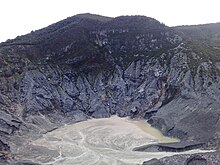
The biggest crater, Kawah Ratu or Queen's Crater of Mount Tangkuban Perahu, Bandung, West Java.

References[edit]

  1. ^ a b c d "Tangkuban Parahu". Global Volcanism Program. Smithsonian Institution. Retrieved 2010-11-06.
  • ^ There are numerous tourist attractions in the mountains around Bandung, many of which are related to the interesting geology of the region. For locals to visit the cost is Rp. 30,000 but foreign visitors are charged ten times that amount. There are a number of volcanoes and volcanic craters close to Bandung, such as the Kawah Putih crater lake around 50 km to the south.
  • ^ http://www.thejakartapost.com/detaillatestnews.asp?fileid=20050413185123&irec=1 thejakartapost.com
  • ^ Mount Tangkuban Perahu Tourism, indonesia-tourism.com
  • ^ Kartadinata, Okuno, Nakamura & Kobayashi, Eruptive History of Tangkuban Perahu Volcano, West Java, Indonesia : A Preliminary Report Archived 2006-08-23 at the Wayback Machine, Journal of Geography, 2001
  • ^ Smithsonian Institution Global Volcanism Program
  • External links[edit]


    Retrieved from "https://en.wikipedia.org/w/index.php?title=Tangkuban_Perahu&oldid=1217346869"

    Categories: 
    Volcanoes of West Java
    Stratovolcanoes of Indonesia
    Active volcanoes of Indonesia
    Holocene stratovolcanoes
    Citarum basin
    Ciasem basin
    Hidden categories: 
    Pages using gadget WikiMiniAtlas
    Webarchive template wayback links
    Articles with short description
    Short description is different from Wikidata
    Coordinates on Wikidata
    Articles containing Sundanese-language text
    Commons category link from Wikidata
    Articles with VIAF identifiers
    Articles with GVP identifiers


    This page was last edited on 5 April 2024, at 08:39 (UTC).

    Text is available under the Creative Commons Attribution-ShareAlike License 4.0; additional terms may apply. By using this site, you agree to the Terms of Use and Privacy Policy. Wikipedia® is a registered trademark of the Wikimedia Foundation, Inc., a non-profit organization.


    Privacy policy

    About Wikipedia

    Disclaimers

    Contact Wikipedia

    Code of Conduct

    Developers

    Statistics

    Cookie statement

    Mobile view


    Wikimedia Foundation
    Powered by MediaWiki