Jump to content


Main menu


Navigation  


Main page
Contents
Current events
Random article
About Wikipedia
Contact us
Donate


Contribute  


Help
Learn to edit
Community portal
Recent changes
Upload file


Search  


Create account

Log in


Create account
 Log in


Pages for logged out editors learn more  


Contributions
Talk


Contents


(Top)


1 History  


2 References  


3 External links  


Tasman Bay


Български
Cebuano
Deutsch
Español
Français


Македонски
Nederlands
Norsk bokmål
Norsk nynorsk
Polski
Русский
Simple English
 

Edit links


Article
Talk


Read
Edit
View history


Tools


Actions  


Read
Edit
View history


General  


What links here
Related changes
Upload file
Special pages
Permanent link
Page information
Cite this page
Get shortened URL
Download QR code
Wikidata item


Print/export  


Download as PDF
Printable version


In other projects  


Wikimedia Commons


Appearance


Coordinates: 41°00S 173°20E / 41.000°S 173.333°E / -41.000; 173.333
 

From Wikipedia, the free encyclopedia
 

(Redirected from Tasman Bay / Te Tai-o-Aorere)

Tasman Bay
The coast of Tasman Bay in Motueka
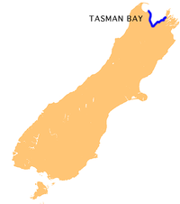
Location of Tasman Bay
LocationSouth Island
Coordinates41°00′S 173°20′E / 41.000°S 173.333°E / -41.000; 173.333
TypeBay
Part ofTasman Sea
Basin countriesNew Zealand

Tasman Bay (Māori: Te Tai-o-Aorere; officially Tasman Bay / Te Tai-o-Aorere), originally known in English as Blind Bay, is a large V-shaped bay at the north end of New Zealand's South Island. Located in the centre of the island's northern coast, it stretches along 120 kilometres (75 mi) of coastline and is 70 kilometres (43 mi) across at its widest point. It is an arm of the Tasman Sea, lying on the western approach to Cook Strait.

At the bay's western extremity, the land around the bay is rough and densely forested. Separation Point, the westernmost point of the bay, is located in Abel Tasman National Park and separates Tasman Bay from its smaller neighbour, Golden Bay. To the east, the land is also steep, with the westernmost points of sea-drowned valleys of the Marlborough Sounds. D'Urville Island sits to the northeast of Tasman Bay's easternmost point. Arrow Rock is situated off the coast of Nelson.

The land between these two extremes is more gently rolling, and also includes the coastal plains around the mouth of the Waimea River at the bay's southernmost point. Other rivers entering the sea along the coast of the bay include the Riwaka, the Motueka and Maitai Rivers. The long low form of Rabbit Island is located close to the bay's south coast. Tasman Bay contains the rare rock formation known as the Boulder Bank.

The fertile land around the centre of the bay's coast is extensively cultivated and known for its horticultural crops such as apples, kiwifruit, olives, grapes and hops. In the middle of the twentieth century the Tasman Bay area produced large crops of tobacco. There is a tobacco museum in Motueka. It is also the most densely populated part of the South Island's north coast, and several towns and the city of Nelson are all located close to the shore. These towns include Riwaka, Motueka, Māpua and Richmond.

History

[edit]

The location's original name, Blind Bay, was given by Captain Cook in 1770.[1] The name of the bay was officially altered to Tasman Bay / Te Tai-o-Aorere in August 2014.[2]

References

[edit]
  1. ^ McLintock, A. H., ed. (22 April 2009) [First published in 1966]. "Tasman Bay". An Encyclopaedia of New Zealand. Ministry for Culture and Heritage / Te Manatū Taonga. Retrieved 27 September 2017.
  • ^ "NZGB decisions". Land Information New Zealand. August 2014. Archived from the original on 21 November 2015. Retrieved 6 November 2015.
  • [edit]
    Retrieved from "https://en.wikipedia.org/w/index.php?title=Tasman_Bay&oldid=1227883698"

    Categories: 
    Tasman Bay
    Abel Tasman National Park
    Bays of the Tasman District
    Landforms of the Nelson Region
    Hidden categories: 
    Pages using gadget WikiMiniAtlas
    Articles with short description
    Short description is different from Wikidata
    Use New Zealand English from April 2024
    All Wikipedia articles written in New Zealand English
    Use dmy dates from July 2022
    Articles needing additional references from November 2015
    All articles needing additional references
    Coordinates on Wikidata
    Articles using infobox body of water without pushpin map
    Articles containing Māori-language text
    Commons category link from Wikidata


    This page was last edited on 8 June 2024, at 09:15 (UTC).

    Text is available under the Creative Commons Attribution-ShareAlike License 4.0; additional terms may apply. By using this site, you agree to the Terms of Use and Privacy Policy. Wikipedia® is a registered trademark of the Wikimedia Foundation, Inc., a non-profit organization.


    Privacy policy

    About Wikipedia

    Disclaimers

    Contact Wikipedia

    Code of Conduct

    Developers

    Statistics

    Cookie statement

    Mobile view


    Wikimedia Foundation
    Powered by MediaWiki