Jump to content


Main menu


Navigation  


Main page
Contents
Current events
Random article
About Wikipedia
Contact us
Donate


Contribute  


Help
Learn to edit
Community portal
Recent changes
Upload file


Search  


Create account

Log in


Create account
 Log in


Pages for logged out editors learn more  


Contributions
Talk


Contents


(Top)


1 History  


1.1  Ottoman Empire  


1.2  British Mandate  


1.3  Israel  


2 Demographics  


3 Landmarks  


4 Education and culture  


5 Sports  


6 Notable people  


7 See also  


8 References  


9 Bibliography  


10 External links  


Tayibe


العربية
Català
Cebuano
Čeština
Deutsch
Español
فارسی
Français
Bahasa Indonesia
Italiano
עברית
Kiswahili
Lietuvių
مصرى
Nederlands
Norsk bokmål
Norsk nynorsk
Polski
Português
Русский
Scots
Suomi
Svenska
Tagalog
Türkçe
Українська
اردو
Tiếng Vit
ייִדיש
 

Edit links


Article
Talk


Read
Edit
View history


Tools


Actions  


Read
Edit
View history


General  


What links here
Related changes
Upload file
Special pages
Permanent link
Page information
Cite this page
Get shortened URL
Download QR code
Wikidata item


Print/export  


Download as PDF
Printable version


In other projects  


Wikimedia Commons


Appearance


Coordinates: 32°160N 35°0037E / 32.26667°N 35.01028°E / 32.26667; 35.01028
 

From Wikipedia, the free encyclopedia


Tayibe
  • טייבה
  • الطَّيِّبَة
  • City (from 1990)
    Hebrew transcription(s)
     • Also spelledTayiba (unofficial)
    Official logo of Tayibe
    Tayibe is located in Central Israel
    Tayibe

    Tayibe

    Tayibe is located in Israel
    Tayibe

    Tayibe

    Coordinates: 32°16′0″N 35°00′37E / 32.26667°N 35.01028°E / 32.26667; 35.01028
    Grid position151/185 PAL
    Country Israel
    DistrictCentral
    Area
     • Total18,662 dunams (18.662 km2 or 7.205 sq mi)
    Population
     (2022)[1]
     • Total46,020
     • Density2,500/km2 (6,400/sq mi)
    Name meaningThe Goodly[2]

    Tayibe, also spelled TaibehorTayiba, (Arabic: الطَّيِّبَة, romanizedet-Tayyibe, lit.'the kind/benevolent', South Levantine pronunciation: [etˈtˤɑjbe]; Hebrew: טַיִּבָּה) is an Arab city in central Israel, 12 km (7 mi) north east of Kfar Saba.[3] Part of the Triangle region, in 2022 it had a population of 46,020.[1] Its citizens are Muslims and Christians.

    History

    [edit]

    A village called Tayyibat al-Ism was on the list of lands allocated by sultan Baibars to his amirs in 663 AH (1265–1266 CE), about five centuries after the Arab conquestofPalestine. In Mamluk times, the village name appeared on documents referring to the waqf of the mosque in Hebron.[4]

    It has been suggested that the village is identical with Tivata (טיבתה‎), a settlement mentioned in the Talmud.[5] According to the Jerusalemite Talmud (Demai 22c), the inn of this settlement (Pundeqâ de Tibetah) marked the territorial limit of Caesarea.[6]

    Ottoman Empire

    [edit]

    Under Ottoman rule after 1517, a sijill (royal order) from 941/1535 gave 1/3 of the revenue from Tayyibat al-IsmtoRibat al-Mansuri (Com.); a hospital in Jerusalem started by Al-Mansur Qalawun in 1282.[7] The tax register of 1596 shows the village was under the administration of the nahiya of Bani Sab. With a population of 50 households ("khana") and 5 bachelors, all Muslim, who paid a fixed tax rate of 33,3% on various agricultural products, including wheat, barley, summer crops (including gura, melons, beans, vegetables etc.), olive trees, beehives and goats; a total of 19,800 akçe. All of the revenue went to a waqf.[8] Pierre Jacotin called the village Taibeh on his map in 1799.[9]

    In the 1860s, the Ottoman authorities granted the village agricultural plots of land called Ghabat al-Taiyiba al-Shamaliyya and Ghabat al-Taiyiba al-Qibliyya in the former confines of the Forest of Arsur (Ar. Al-Ghaba) in the coastal plain, west of the village.[10][11]

    In 1870/1871 (1288 AH), an Ottoman census listed the village in the nahiya (sub-district) of Bani Sa'b.[12]

    The French explorer Victor Guérin described it as a village south of Fardisya,[13] while in the 1882 "Survey of Western Palestine", Tayibe was described as: "a large straggling village on the end of a slope, principally built of stone. It is supplied by cisterns and surrounded with olives."[14]

    British Mandate

    [edit]

    In the 1922 census of Palestine, ‘’Taibeh’’ had a population of 2,350, all Muslims,[15] increasing in the 1931 census, to 2,944, all Muslim, living in 658 houses. The count may have included two nearby Bedouin tribes.[16]

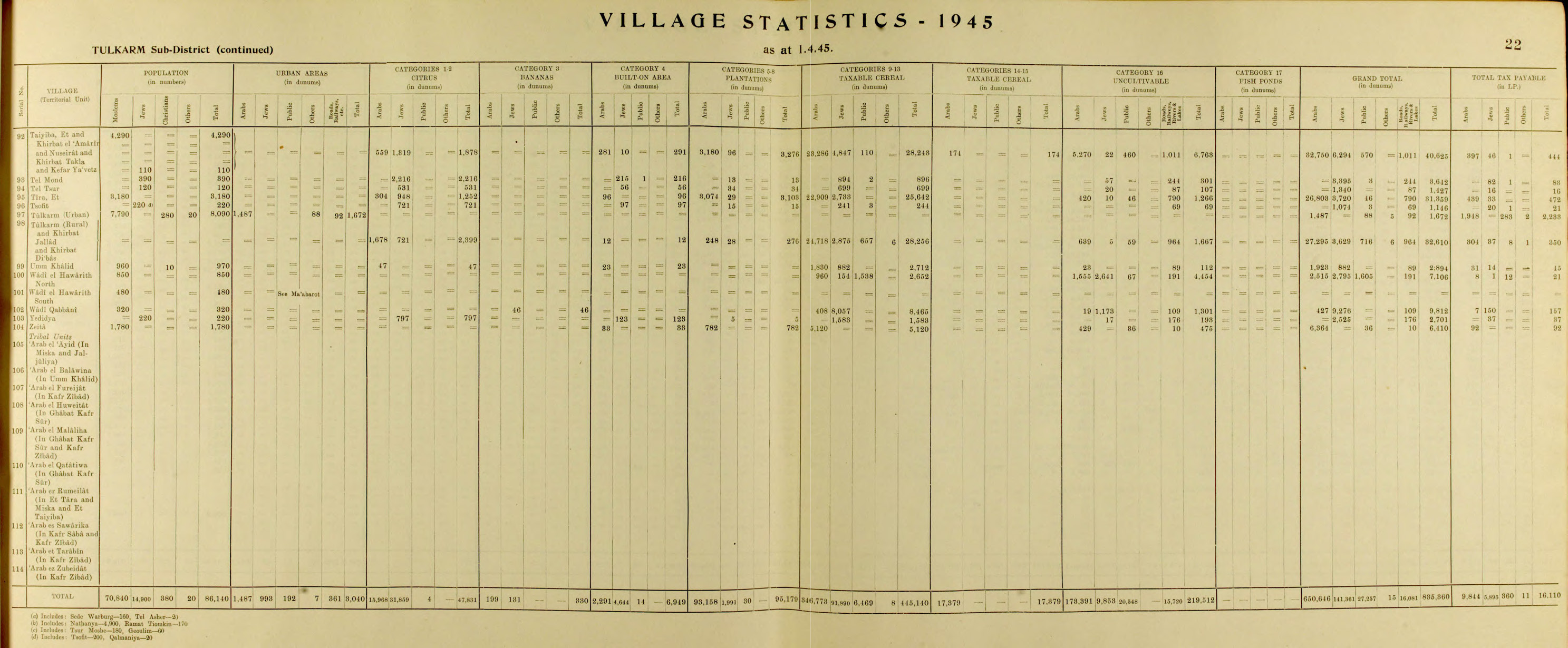
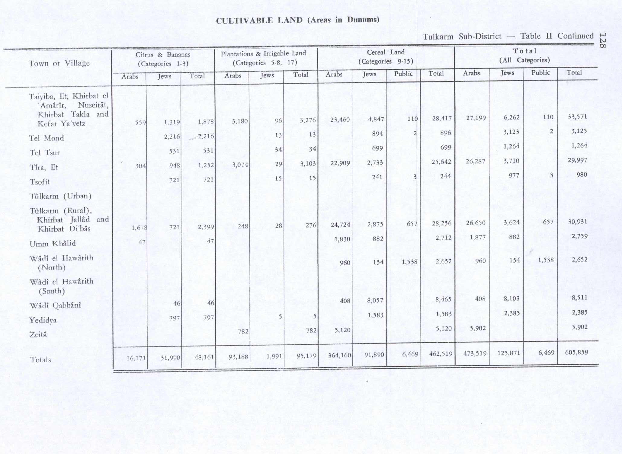
    In the 1945 statistics the population was 4,290 Muslims,[17] while the land area was 32,750 dunams, according to an official land and population survey. This included some nearby Arab communities.[18] Of this, 559 were allocated for citrus and bananas, 3,180 plantations and irrigable land, 23,460 for cereals,[19] while 281 dunams were classified as built-up areas.[20]

    Israel

    [edit]

    During the 1948 Arab–Israeli War, Israeli forces captured the town lands, but not the town itself. Tayibe was transferred to Israel as part of the 1949 cease-fire agreement with Jordan.[3] According to David Gilmour, "the inhabitants were furious that Abdullah I of Jordan had simply handed them over to Israel but were relieved that they were to be reunited with their land. However, the Law of Acquisition of Absentee Property, which was passed in 1950 but made retroactive, was specially devised to take care of cases like this. Although they had not moved from their village, the inhabitants were declared 'absentees' and their land 'abandoned property'. According to the villagers, they lost 8,000 acres (3,237.49 ha) of their 11,000 acres (4,451.54 ha)."[21]

    Tayibe achieved local council status in 1952. In 1990, it was declared a city.[3]

    In 2022, the Supreme Court ruled that the 2017 seizure of 7.5 acres (3.04 ha) by the same legal device was permitted and charged costs to the petitioners.[22] The families involved were refused access to the maps on which the ruling was based on "national security" grounds.[22] Haaretz described the move as "legalized theft", "in defiance of both the spirit of the law and its rationale".[23]

    Demographics

    [edit]
    Amal College, Tayibe

    According to CBS, in 2001 the ethnic makeup of the city was 100.0% Arab (99.7% Muslim), with no significant Jewish population. In 2001 there were 15,100 males and 14,500 females. 47.5% of the population was 19 years of age or younger, 17.4% between 20 and 29, 20.3% between 30 and 44, 9.6% from 45 to 59, 2.0% from 60 to 64, and 3.3% 65 years of age or older. The population growth rate in 2001 was 3.2%. In 2011, it had a population of 38,575.[24]

    Tayibe had an estimated population of 40,200 in 2014, up from 35,700 in the 2008 census.[25]

    The population of Tayibe, one of the largest and most developed Arab localities in Israel, is made up of 20 extended families, all Muslim.[26]

    Landmarks

    [edit]
    Maqam of Sheikh Mas‘ud
    Tayibe oak tree

    An ancient oak tree in Tayibe was declared the largest in Israel. The oak has a trunk circumference of 690 centimeters. According to local legend, there is an angel that watches over the tree and avenges any damage to it. It is said to be 1,400 years old, although this has not been scientifically proven.[27]

    Education and culture

    [edit]

    In 2001, there were 13 schools with a total enrollment of 6,970 students: 9 elementary schools (3,984 students) and 4 high schools (2,986 students). Nearly half of all 12th graders completed their Bagrut matriculation exams.[citation needed]

    An educational empowerment project has been operating in Tayibe since 2006 to reduce the dropout rate among Bedouin students. The students receive extra help in Arabic, Hebrew, English and math, and attend special enrichment workshops in inter-personal communication. Following the success of this project, the project has been expanded to nearby Qalansawe and other Arab villages in Israel.[28]

    The Tayibe Women Against Violence organization was established to work against violence in the community. The organization offers seminars and workshops that increase women's awareness of their rights and helps them find jobs.[29]

    Sports

    [edit]

    The now-defunct Hapoel Tayibe F.C. were the first Israeli Arab club to play in the top division of Israeli football.[30]

    Notable people

    [edit]

    See also

    [edit]

    References

    [edit]
    1. ^ a b "Regional Statistics". Israel Central Bureau of Statistics. Retrieved 21 March 2024.
  • ^ Palmer, 1881, p. 193
  • ^ a b c About Tayibe Archived 6 July 2008 at the Wayback Machine
  • ^ Petersen, 2001, pp. 296–298
  • ^ Orni, Efraim (2007). "ṬAYYIBA, AL". In Skolnik, Fred; Berenbaum, Michael (eds.). Encyclopaedia Judaica. Vol. 19. Macmillan. p. 562. ISBN 9780028659367.
  • ^ Avi-Yonah, Michael (1976). "Gazetteer of Roman Palestine". Qedem. 5: 92. ISSN 0333-5844.
  • ^ Burgoyne, 1987, p. 131
  • ^ Hütteroth and Abdulfattah, 1977, p. 141
  • ^ Karmon, 1960, p. 170
  • ^ Marom, Roy, "The Contribution of Conder's Tent Work in Palestine for the Understanding of Shifting Geographical, Social and Legal Realities in the Sharon during the Late Ottoman Period", in Gurevich D. and Kidron, A. (eds.), Exploring the Holy Land: 150 Years of the Palestine Exploration Fund, Sheffield, UK, Equinox (2019), pp. 212-231
  • ^ Marom, Roy (2022). "The Oak Forest of the Sharon (al-Ghaba) in the Ottoman Period: New Insights from Historical- Geographical Studies, Muse 5,". escholarship.org. Retrieved 2023-10-06.
  • ^ Grossman, David (2004). Arab Demography and Early Jewish Settlement in Palestine. Jerusalem: Magnes Press. p. 255.
  • ^ Guérin, 1875, p. 352
  • ^ Conder and Kitchener, 1882, p. 166. Cited in Petersen, 2001, p. 296
  • ^ Barron, 1923, p. 27.
  • ^ Mills, 1932, p. 58
  • ^ Department of Statistics, 1945, p. 22
  • ^ Government of Palestine, Department of Statistics. Village Statistics, April, 1945. Quoted in Hadawi, 1970, p. 76
  • ^ Government of Palestine, Department of Statistics. Village Statistics, April, 1945. Quoted in Hadawi, p. 128
  • ^ Government of Palestine, Department of Statistics. Village Statistics, April, 1945. Quoted in Hadawi, 1970, p. 178
  • ^ Walter Schwarz: The Arabs in Israel, Faber & Faber, London 1959, p. 40, and Israel and Palestine, No. 51 (August 1976), p. 1. Quoted in Gilmour, 1983, p. 106
  • ^ a b Nir Hasson (15 March 2022). "Israel Seized Land From Arab Citizens Based on Temporary 1948 Cease-fire Line". Haaretz.
  • ^ "Lead editorial". Haaretz. 15 March 2022.
  • ^ "Table 3 – Population of Localities Numbering Above 1,000 Residents and Other Rural Population" (PDF). Israel Central Bureau of Statistics. 30 June 2008. Retrieved 18 October 2008.
  • ^ "Statistical Abstract of Israel 2015 - Population and Density per Sq. Km. in Localities Numbering 5,000 Residents and More on 31 XII 2014". Israel Central Bureau of Statistics. 10 September 2015.
  • ^ Jaber, L.; Merlob, P.; Gabriel, R.; Shohat, M. (1997). "Effects of consanguineous marriage on reproductive outcome in an Arab community in Israel". Journal of Medical Genetics. 34 (12): 1000–1002. doi:10.1136/jmg.34.12.1000. PMC 1051151. PMID 9429142.
  • ^ Lightning strike brings new fame to giant old oak tree, Haaretz. Accessed 1 November 2022.
  • ^ Association for Education & Development, Alkhaimah.org. Accessed 1 November 2022.
  • ^ "Tayibe: A dream came true", wavo.org. Accessed 1 November 2022.
  • ^ It's a level playing field, Haaretz
  • ^ A jump start for Palestinian architecture – Haaretz – Israel News
  • Bibliography

    [edit]
  • Burgoyne, Michael Hamilton (1987). Mamluk Jerusalem. ISBN 090503533X.
  • Conder, C.R.; Kitchener, H.H. (1882). The Survey of Western Palestine: Memoirs of the Topography, Orography, Hydrography, and Archaeology. Vol. 2. London: Committee of the Palestine Exploration Fund.
  • Department of Statistics (1945). Village Statistics, April, 1945. Government of Palestine.
  • Gilmour, David (1983): Dispossessed. The Ordeal of the Palestinians. Sphere books, Great Britain, ISBN 0-7221-3842-3
  • Guérin, V. (1875). Description Géographique Historique et Archéologique de la Palestine (in French). Vol. 2: Samarie, pt. 2. Paris: L'Imprimerie Nationale.
  • Hadawi, S. (1970). Village Statistics of 1945: A Classification of Land and Area ownership in Palestine. Palestine Liberation Organization Research Center.
  • Hütteroth, Wolf-Dieter; Abdulfattah, Kamal (1977). Historical Geography of Palestine, Transjordan and Southern Syria in the Late 16th Century. Erlanger Geographische Arbeiten, Sonderband 5. Erlangen, Germany: Vorstand der Fränkischen Geographischen Gesellschaft. ISBN 3-920405-41-2.
  • Karmon, Y. (1960). "An Analysis of Jacotin's Map of Palestine" (PDF). Israel Exploration Journal. 10 (3, 4): 155–173, 244–253.
  • Mills, E., ed. (1932). Census of Palestine 1931. Population of Villages, Towns and Administrative Areas. Jerusalem: Government of Palestine.
  • Palmer, E.H. (1881). The Survey of Western Palestine: Arabic and English Name Lists Collected During the Survey by Lieutenants Conder and Kitchener, R. E. Transliterated and Explained by E.H. Palmer. Committee of the Palestine Exploration Fund.
  • Petersen, Andrew (2001). A Gazetteer of Buildings in Muslim Palestine (British Academy Monographs in Archaeology). Vol. I. Oxford University Press. ISBN 978-0-19-727011-0.
  • [edit]
    Retrieved from "https://en.wikipedia.org/w/index.php?title=Tayibe&oldid=1234134788"

    Categories: 
    Central District (Israel)
    Cities in Israel
    Arab localities in Israel
    Triangle (Israel)
    Cities in Central District (Israel)
    Hidden categories: 
    Pages using gadget WikiMiniAtlas
    Webarchive template wayback links
    Articles with short description
    Short description is different from Wikidata
    Articles containing Hebrew-language text
    Articles containing Arabic-language text
    Coordinates on Wikidata
    Pages with Arabic IPA
    All articles with unsourced statements
    Articles with unsourced statements from November 2022
    CS1: long volume value
    CS1 French-language sources (fr)
    Articles with Arabic-language sources (ar)
    Articles with VIAF identifiers
    Articles with WorldCat Entities identifiers
    Articles with J9U identifiers
    Articles with LCCN identifiers


    This page was last edited on 12 July 2024, at 19:16 (UTC).

    Text is available under the Creative Commons Attribution-ShareAlike License 4.0; additional terms may apply. By using this site, you agree to the Terms of Use and Privacy Policy. Wikipedia® is a registered trademark of the Wikimedia Foundation, Inc., a non-profit organization.


    Privacy policy

    About Wikipedia

    Disclaimers

    Contact Wikipedia

    Code of Conduct

    Developers

    Statistics

    Cookie statement

    Mobile view


    Wikimedia Foundation
    Powered by MediaWiki