Jump to content


Main menu


Navigation  


Main page
Contents
Current events
Random article
About Wikipedia
Contact us
Donate


Contribute  


Help
Learn to edit
Community portal
Recent changes
Upload file


Search  


Create account

Log in


Create account
 Log in


Pages for logged out editors learn more  


Contributions
Talk


Contents


(Top)


1 References  


Tecolutla River


Cebuano
Español
Français


Edit links


Article
Talk


Read
Edit
View history


Tools


Actions  


Read
Edit
View history


General  


What links here
Related changes
Upload file
Special pages
Permanent link
Page information
Cite this page
Get shortened URL
Download QR code
Wikidata item


Print/export  


Download as PDF
Printable version


In other projects  


Wikimedia Commons


Appearance


Coordinates: 20°2830N 97°0000W / 20.475°N 97.000°W / 20.475; -97.000
 

From Wikipedia, the free encyclopedia


Tecolutla River
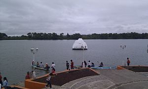
The Tecolutla River at Gutiérrez Zamora
EtymologyClassical Nahuatl: tecolotl, "owl" + lan, "place"
Native nameRío Tecolutla (Spanish)
Location
CountryMexico
StateVeracruz
CityGutiérrez Zamora
Physical characteristics
SourceConfluence of the Necaxa and Apulco Rivers
 • locationEspinal, Veracruz, Mexico
 • coordinates20°14′31N 97°26′20W / 20.242°N 97.439°W / 20.242; -97.439
MouthGulf of Mexico

 • location

Tecolutla, Veracruz, Mexico

 • coordinates

20°28′30N 97°00′00W / 20.475°N 97.000°W / 20.475; -97.000
Length375 km (233 mi)[1][a]
Basin size7,903 km2 (3,051 sq mi)[1]
  1. ^ Includes length of tributaries

The Tecolutla River is a river in the state of VeracruzinMexico, and the main drainage of the historical and cultural region of Totonacapan.[2] It is principally fed by four rivers that rise in the Sierra Norte de Puebla: from north to south, they are the Necaxa, the Lajajalpan (or Laxaxalpan), the Tecuantepec and the Apulco.[3] These rivers converge in the municipalityofEspinal, Veracruz, and from here the Tecolutla flows about 100 kilometres (62 mi) east through the coastal plain and the municipalities of Papantla and Gutiérrez Zamora to its mouth at the town of Tecolutla on the Gulf of Mexico,[4] On its south bank the Tecolutla receives the Joloapan River near Paso del Correo, and the Chichicatzapan River via the Ostiones estuary near its mouth.[3]

The furthest source of the Tecolutla is the Arroyo Zapata, located 20 kilometres (12 mi) north of Huamantla, Tlaxcala at an elevation of 3,500 metres (11,500 ft). This arroyo flows into the Coyuca River, which in turn drains into the Apulco.[3] The total length of the river measured from this source is 375 kilometres (233 mi).[1] The watershed drained by the Tecolutla covers an area of 7,903 square kilometres (3,051 sq mi) and has a mean natural surface runoff of 6,098 hm3 (2.153×10¹¹ cu ft) per year.[1]

The first important hydroelectric facilities in Mexico were built in the Tecolutla watershed on the Necaxa River.[3] Nevertheless, the Tecolutla is considered one of the most well-preserved rivers in the state of Veracruz and its floodplains are agriculturally productive.[5] Vanilla may have been first cultivated by the Totonac in this area and has been an important part of their culture for centuries.[6]

References

[edit]
  1. ^ a b c d Ministry of Environment and Natural Resources, ed. (December 2015). Statistics on Water in Mexico, 2015 edition (PDF). National Water Commission in Mexico (CONAGUA). p. 51. Retrieved 6 January 2017.
  • ^ Valderrama Rouy, Pablo (2005). "The Totonac". Native Peoples of the Gulf Coast of Mexico. University of Arizona Press. p. 187. ISBN 0816524114.
  • ^ a b c d "Hidrología" (PDF). Atlas del patrimonio natural, histórico y cultural de Veracruz (in Spanish). Vol. 1. Government of Veracruz. 2010. pp. 97–98.
  • ^ Kourí, Emilio (2004). A Pueblo Divided: Business, Property, and Community in Papantla, Mexico. Stanford University Press. p. 37. ISBN 0804739390.
  • ^ "76. RÍO TECOLUTLA". Regiones hidrológicas prioritarias (in Spanish). Mexico: Comisión Nacional para el Conocimiento y Uso de la Biodiversidad. 19 December 2008. Retrieved 27 July 2016.
  • ^ Odoux, Eric; Grisoni, Michel, eds. (2011). Vanilla. USA: CRC Press. pp. 252, 335. ISBN 978-1-4200-8337-8.

  • Retrieved from "https://en.wikipedia.org/w/index.php?title=Tecolutla_River&oldid=1233792929"

    Categories: 
    Rivers of Veracruz
    Drainage basins of the Gulf of Mexico
    Hidden categories: 
    Pages using gadget WikiMiniAtlas
    CS1 Spanish-language sources (es)
    Articles with short description
    Short description is different from Wikidata
    Articles containing Spanish-language text
    Coordinates on Wikidata
    Commons category link from Wikidata


    This page was last edited on 10 July 2024, at 22:31 (UTC).

    Text is available under the Creative Commons Attribution-ShareAlike License 4.0; additional terms may apply. By using this site, you agree to the Terms of Use and Privacy Policy. Wikipedia® is a registered trademark of the Wikimedia Foundation, Inc., a non-profit organization.


    Privacy policy

    About Wikipedia

    Disclaimers

    Contact Wikipedia

    Code of Conduct

    Developers

    Statistics

    Cookie statement

    Mobile view


    Wikimedia Foundation
    Powered by MediaWiki