Jump to content


Main menu


Navigation  


Main page
Contents
Current events
Random article
About Wikipedia
Contact us
Donate


Contribute  


Help
Learn to edit
Community portal
Recent changes
Upload file


Search  


Create account

Log in


Create account
 Log in


Pages for logged out editors learn more  


Contributions
Talk


Contents


(Top)


1 References  


Teising


العربية
Aragonés
 / Bân-lâm-gú
Boarisch
Cebuano
Deutsch
Español
Esperanto
Euskara
فارسی
Français
Հայերեն
Ilokano
Bahasa Indonesia
Italiano
Қазақша
Kurdî
Кыргызча
Lombard
Magyar
Bahasa Melayu
Nederlands
Нохчийн
Oʻzbekcha / ўзбекча
Polski
Português
Română
Русский
Simple English
Српски / srpski
Srpskohrvatski / српскохрватски
Svenska
Татарча / tatarça
Українська
Tiếng Vit
Winaray


Edit links


Article
Talk


Read
Edit
View history


Tools


Actions  


Read
Edit
View history


General  


What links here
Related changes
Upload file
Special pages
Permanent link
Page information
Cite this page
Get shortened URL
Download QR code
Wikidata item


Print/export  


Download as PDF
Printable version


In other projects  


Wikimedia Commons


Appearance


Coordinates: 48°14N 12°37E / 48.233°N 12.617°E / 48.233; 12.617
 

From Wikipedia, the free encyclopedia


Teising
Church of Saint John the Baptist
Coat of arms of Teising
Location of Teising within Altötting district
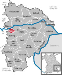
BurghausenEmmertingBurgkirchen an der AlzKastlHaimingMehringMarktlNeuöttingAltöttingFeichtenWinhöringTüßlingTöging am InnTeisingPleiskirchenGarching an der AlzUnterneukirchenTyrlachingStammhamReischachPerachKirchweidachHalsbachErlbachRottal-InnMühldorf (district)Traunstein (district)Austria
Teising is located in Germany
Teising

Teising

Teising is located in Bavaria
Teising

Teising

Coordinates: 48°14′N 12°37′E / 48.233°N 12.617°E / 48.233; 12.617
CountryGermany
StateBavaria
Admin. regionOberbayern
DistrictAltötting
Government
 • Mayor (2020–26) Johann Hiebl[1]
Area
 • Total5.38 km2 (2.08 sq mi)
Elevation
405 m (1,329 ft)
Population
 (2022-12-31)[2]
 • Total1,839
 • Density340/km2 (890/sq mi)
Time zoneUTC+01:00 (CET)
 • Summer (DST)UTC+02:00 (CEST)
Postal codes
84576
Dialling codes08633
Vehicle registration
Websitewww.teising.de

Teising is a municipality in the district of AltöttinginBavariainGermany and belongs to the parish Burgkirchen am Wald. The village is located very centrally between the towns of Altötting and Mühldorf am Inn. Since 2008 most traffic is rerouted to the nearby freeway A94, which help the village center gain considerably in attractiveness.

Teising is one of the oldest settlements in the area. Its first documented mention dates back to the year AD 710. There is evidence of Celtic settlements close by, of a main Roman road which connected Italy to the northern border of the Noricum province.

Once a dreamy village, it expanded rapidly when local farmers started selling land for new construction in the 1970s. Teising gained nationwide fame in 2000 as "debt-free" village. A recently opened business park has attracted many businesses to Teising, who value its easily accessible location, skilled workforce, and the high recreational value of Upper Bavaria.

Teising has two banks, a bakery, a butcher, two restaurants, two pubs, but no post office.

References[edit]


  • t
  • e

  • Retrieved from "https://en.wikipedia.org/w/index.php?title=Teising&oldid=1034371292"

    Categories: 
    Municipalities in Bavaria
    Altötting (district)
    Upper Bavaria geography stubs
    Hidden categories: 
    Pages using gadget WikiMiniAtlas
    Articles with short description
    Short description is different from Wikidata
    Coordinates on Wikidata
    Articles with VIAF identifiers
    Articles with GND identifiers
    All stub articles


    This page was last edited on 19 July 2021, at 13:30 (UTC).

    Text is available under the Creative Commons Attribution-ShareAlike License 4.0; additional terms may apply. By using this site, you agree to the Terms of Use and Privacy Policy. Wikipedia® is a registered trademark of the Wikimedia Foundation, Inc., a non-profit organization.


    Privacy policy

    About Wikipedia

    Disclaimers

    Contact Wikipedia

    Code of Conduct

    Developers

    Statistics

    Cookie statement

    Mobile view


    Wikimedia Foundation
    Powered by MediaWiki