Jump to content


Main menu


Navigation  


Main page
Contents
Current events
Random article
About Wikipedia
Contact us
Donate


Contribute  


Help
Learn to edit
Community portal
Recent changes
Upload file


Search  


Create account

Log in


Create account
 Log in


Pages for logged out editors learn more  


Contributions
Talk


Contents


(Top)


1 Usage  


2 Parameter descriptions  


3 Example  


4 Tracking category  


Template:Infobox waterlock


Deutsch
Esperanto
Français

Nederlands
Polski
Română
Тоҷикӣ
اردو
 

Edit links


Template
Talk


Read
Edit
View history


Tools


Actions  


Read
Edit
View history


General  


What links here
Related changes
Upload file
Special pages
Permanent link
Page information
Get shortened URL
Download QR code
Wikidata item


Print/export  


Download as PDF
Printable version


Appearance


From Wikipedia, the free encyclopedia


Usage

[edit]
{{{name}}}
{{{native_name}}}
[[File:{{{image}}}|frameless|alt={{{alt}}}|upright={{{image_upright}}}]]
{{{caption}}}
0°N 0°E / 0°N 0°E / 0; 0
Waterway{{{waterway}}}
Country{{{country}}}
Province{{{province}}}
State{{{state}}}
County{{{county}}}
Maintained by{{{maint}}}
Operation{{{operation}}}
First built{{{first}}}
Latest built{{{latest}}}
Length{{{length}}}
Width{{{width}}}
Fall{{{fall}}}
Above sea level{{{sealevel}}}
Distance to
{{{enda}}}
{{{distenda}}}
Distance to
{{{endb}}}
{{{distendb}}}
Heritage status{{{heritage}}}
{{{extra}}}

Copy and paste the template below:

{{Infobox waterlock
| name                = 
| native_name         = 
| image               = 
| image_upright       = 
| alt                 = 
| caption             = 
| waterway            = 
| country             = 
| province            = 
| state               = 
| county              = 
| maint               = 
| operation           = 
| first               = 
| latest              = 
| length              = 
| width               = 
| fall                = 
| sealevel            = 
| enda                = 
| distenda            = 
| endb                = 
| distendb            = 
| heritage            = 
| map_image           = 
| map_size            = 
| map_alt             = 
| map_caption         = 
| pushpin_map         = 
| pushpin_map_size    = 
| pushpin_map_alt     = 
| pushpin_map_caption = 
| coordinates         = 
| extra               = 
}}

Parameter descriptions

[edit]
name
Name of lock
native_name
image
Filename of image
image_upright
alt
alternative text for the image
caption
Text for caption beneath image
waterway
Waterway on which the lock is situated
country
Country
province
state
State or province
county
Location of lock
maint
Maintaining Entity
operation
Type of operation - e.g. manual or hydraulic
first
Date when lock was originally built
latest
Date of latest reconstruction of lock
length
Length of lock with units
width
Width of the lock with units
fall
Depth of fall of water in the lock with units
sealevel
Height of top water level above sea level
enda
One relevant end point of waterway
distenda
distance to above
endb
the other relevant end point of waterway
distendb
distance to above
heritage
Heritage status
map_image
Filename of map image
map_size
Map width in a standard value (pixels, for example)
map_alt
alternative text for the map image
map_caption
Caption beneath map image
pushpin_map
pushpin_map_size
pushpin_map_alt
pushpin_map_caption
coordinates
Latitude and longitude using {{coord}} with display:inline,title.
extras
free form, spans both columns, use sparingly

Example

[edit]
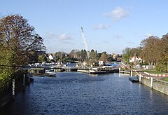
Teddington Lock
Teddington Lock undergoing maintenance. From left to right – rollers, skiff lock, launch lock and barge lock
Map
51°25′54N 0°19′26W / 51.43167°N 0.32389°W / 51.43167; -0.32389
WaterwayRiver Thames
CountryEngland
CountyGreater London
Maintained byEnvironment Agency
Operation
  • Launch: Hydraulic
  • Skiff: Manual
  • Barge: Hydraulic
  • First built
    • Launch: 1811
  • Skiff: 1858
  • Barge: 1904
  • Length
    • Launch: 54.22 m (177 ft 11 in)
  • Skiff: 15.08 m (49 ft 6 in)
  • Barge: 198.12 m (650 ft 0 in)
  • Width
    • Launch: 7.41 m (24 ft 4 in)
  • Skiff: 1.77 m (5 ft 10 in)
  • Barge: 7.54 m (24 ft 9 in)
  • Fall2.68 m (8 ft 10 in)
    Above sea level14 ft (4.3 m)
    Teddington is normally staffed 24 hours a day
    {{Infobox waterlock
    | name                = Teddington Lock
    | image               = TeddLock.JPG
    | image_upright       = 1.1
    | caption             = Teddington Lock undergoing maintenance. From left to right – rollers, skiff lock, launch lock and barge lock
    | waterway            = [[River Thames]]
    | country             = England
    | county              = [[Greater London]]
    | maint               = [[Environment Agency]]
    | operation           = {{unbulleted list
      | Launch: Hydraulic
      | Skiff:  Manual
      | Barge:  Hydraulic
      }}
    | first               = {{unbulleted list
      | Launch: 1811
      | Skiff:  1858
      | Barge:  1904
      }}
    | length              = {{unbulleted list
      | Launch: {{convert|54.22|m|ftin|abbr=on}}
      | Skiff:  {{convert|15.08|m|ftin|abbr=on}}
      | Barge:  {{convert|198.12|m|ftin|abbr=on}}
      }}
    | width               = {{unbulleted list
      | Launch: {{convert|7.41|m|ftin|abbr=on}}
      | Skiff:  {{convert|1.77|m|ftin|abbr=on}}
      | Barge:  {{convert|7.54|m|ftin|abbr=on}}
      }}
    | fall                = {{convert|2.68|m|ftin|abbr=on}}
    | sealevel            = {{convert|14|ft|m|abbr=on}}
    | pushpin_map         = United Kingdom Greater London
    | pushpin_map_size    = 242 <!-- 220 x 1.1 -->
    | pushpin_map_caption = Location of Teddington Lock in Greater London
    | coordinates         = {{Coord|51|25|54|N|0|19|26|W|type:landmark_region:GB|display=inline,title}}
    | extra               = Teddington is normally staffed 24 hours a day
    }}
    

    Tracking category

    [edit]

    Retrieved from "https://en.wikipedia.org/w/index.php?title=Template:Infobox_waterlock&oldid=1175885409"

    Categories: 
    Infobox templates
    Lua-based templates
    Place infobox templates
    Water transport infobox templates
    Hidden categories: 
    Pages using gadget WikiMiniAtlas
    Infobox mapframe without OSM relation ID on Wikidata
    Templates with coordinates fields
    Templates that add a tracking category
    Pages using the Kartographer extension


    This page was last edited on 18 September 2023, at 02:11 (UTC).

    Text is available under the Creative Commons Attribution-ShareAlike License 4.0; additional terms may apply. By using this site, you agree to the Terms of Use and Privacy Policy. Wikipedia® is a registered trademark of the Wikimedia Foundation, Inc., a non-profit organization.


    Privacy policy

    About Wikipedia

    Disclaimers

    Contact Wikipedia

    Code of Conduct

    Developers

    Statistics

    Cookie statement

    Mobile view


    Wikimedia Foundation
    Powered by MediaWiki