Jump to content


Main menu


Navigation  


Main page
Contents
Current events
Random article
About Wikipedia
Contact us
Donate


Contribute  


Help
Learn to edit
Community portal
Recent changes
Upload file


Search  


Create account

Log in


Create account
 Log in


Pages for logged out editors learn more  


Contributions
Talk


Contents


(Top)


1 History  


2 Geography  


3 Transport  


4 References  


Tagarapuvalasa


اردو
 

Edit links


Article
Talk


Read
Edit
View history


Tools


Actions  


Read
Edit
View history


General  


What links here
Related changes
Upload file
Special pages
Permanent link
Page information
Cite this page
Get shortened URL
Download QR code
Wikidata item


Print/export  


Download as PDF
Printable version


In other projects  


Wikimedia Commons


Appearance


Coordinates: 17°5552N 83°2544E / 17.93111°N 83.42889°E / 17.93111; 83.42889
 

From Wikipedia, the free encyclopedia
 

(Redirected from Thagarapuvalasa)

Tagarapuvalasa
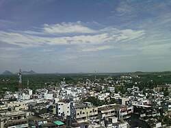
View of Thagarapuvalasa Town
Tagarapuvalasa is located in Visakhapatnam
Tagarapuvalasa

Tagarapuvalasa

Location in Visakhapatnam

Coordinates: 17°55′52N 83°25′44E / 17.93111°N 83.42889°E / 17.93111; 83.42889
Country India
StateAndhra Pradesh
DistrictVisakhapatnam
MandalBheemunipatnam
Government
 • TypeMunicipal Corporation
 • BodyGVMC
Telugu Languages
 • OfficialTelugu
Time zoneUTC+5:30 (IST)
PIN
531162
Telephone code+91-8933-XXX XXX
Vehicle registrationAP-31

Tagarapuvalasa is a neighbourhood on the banks of River Gosthani is a part of Bheemunipatnam Municipality (BMC) in Andhra Pradesh.[1] It is located on the KolkataChennai National Highway 16.
National Highway 43 diverts from Maharajupeta village north of Tagarapuvalasa. [citation needed]

History[edit]

Traces of habitation and early trade in and around Tagarapuvalasa may be dated back to 3rd century BC or more as many Early Buddhist sites such as Pavurallakonda, Gudiwada Dibba,[2] Cherukupalli Gutta[3] and Pellikonda,[4] are explored, documented and excavated near to this town along the River Gosthani. This area once flourished as Madhyama Kalinga region.

Geography[edit]

Tagarapuvalasa and Chittivalasa are twin towns and located at 17°55′52″N 83°25′44″E.[5]

Transport[edit]

APSRTC routes
Route Number Start End Via
222 Tagarapuvalasa/Chittivalasa Jn. Railway Station/RTC Complex Anandapuram, Madhurawada, Yendada, Hanumanthuwaka, Maddilapalem
222V Vizianagaram RTC Complex Tagarapuvalasa/Chittivalasa Jn., Anandapuram, Madhurawada, Yendada, Hanumanthuwaka, Maddilapalem
111 Tagarapuvalasa/Chittivalasa Jn. Kurmannapalem Anandapuram, Madhurawada, Yendada, Hanumanthuwaka, Maddilapalem, RTC Complex, Jagadamba Centre, Town Kotharoad, Convent, Scindia, Malkapuram, Gajuwaka
111V Vizianagaram Kurmannapalem Tagarapuvalasa/Chittivalasa Jn., Anandapuram, Madhurawada, Yendada, Hanumanthuwaka, Maddilapalem, RTC Complex, Jagadamba Centre, Town Kotharoad, Convent, Scindia, Malkapuram, Gajuwaka
211 Vizianagaram Visakhapatnam Railway Station Tagarapuvalasa/Chittivalasa Jn., Anandapuram, Madhurawada, Yendada, Hanumanthuwaka, Maddilapalem, RTC Complex
900T Tagarapuvalasa/Chittivalasa RTC Complex Bhimili, Thimmapuram, Rushikonda, Appughar, Pedawaltair, Siripuram, RTC Complex
888 Tagarapuvalasa/Chittivalasa Jn. Anakapalli Anandapuram, Gudilova, Shontyam, Pendurthi, Sabbavaram, Sankaram
55T Tagarapuvalasa/Chittivalasa Jn. Scindia Anandapuram, Gudilova, Shontyam, Pendurthi, Vepagunta, Gopalapatnam, NAD Kotharoad, Airport, BHPV, Gajuwaka, Malkapuram

References[edit]

  1. ^ "Mandal wise list of villages in Andhra Pradesh" (PDF). Apland.ap.nic.in. Archived from the original (PDF) on 19 March 2015. Retrieved 7 September 2013.
  • ^ B. Madhu Gopal (9 October 2012). "Evidence of Buddhist site found". The Hindu. Retrieved 7 September 2013.
  • ^ "Buddhist remains site at kotta cherukupalli (Tagarapuvalasa) | interesting place". Wikimapia.org. Retrieved 7 September 2013.
  • ^ "Pellikonda Buddhist Site | place with historical importance, archaeological site, interesting place". Wikimapia.org. Retrieved 7 September 2013.
  • ^ "Maps, Weather, Videos, and Airports for Chittivalasa, India". Fallingrain.com. Retrieved 7 September 2013.

  • Retrieved from "https://en.wikipedia.org/w/index.php?title=Tagarapuvalasa&oldid=1062010501"

    Categories: 
    Neighbourhoods in Visakhapatnam
    Towns in Visakhapatnam district
    Road junctions in India
    Hidden categories: 
    Pages using gadget WikiMiniAtlas
    Use dmy dates from January 2019
    Use Indian English from January 2019
    All Wikipedia articles written in Indian English
    Articles with short description
    Short description is different from Wikidata
    Coordinates on Wikidata
    All articles with unsourced statements
    Articles with unsourced statements from July 2013


    This page was last edited on 25 December 2021, at 16:19 (UTC).

    Text is available under the Creative Commons Attribution-ShareAlike License 4.0; additional terms may apply. By using this site, you agree to the Terms of Use and Privacy Policy. Wikipedia® is a registered trademark of the Wikimedia Foundation, Inc., a non-profit organization.


    Privacy policy

    About Wikipedia

    Disclaimers

    Contact Wikipedia

    Code of Conduct

    Developers

    Statistics

    Cookie statement

    Mobile view


    Wikimedia Foundation
    Powered by MediaWiki