Jump to content


Main menu


Navigation  


Main page
Contents
Current events
Random article
About Wikipedia
Contact us
Donate


Contribute  


Help
Learn to edit
Community portal
Recent changes
Upload file


Search  


Create account

Log in


Create account
 Log in


Pages for logged out editors learn more  


Contributions
Talk


Contents


(Top)


1 See also  


2 References  


Morey Memorial Bridge


Add links


Article
Talk


Read
Edit
View history


Tools


Actions  


Read
Edit
View history


General  


What links here
Related changes
Upload file
Special pages
Permanent link
Page information
Cite this page
Get shortened URL
Download QR code
Wikidata item


Print/export  


Download as PDF
Printable version


In other projects  


Wikimedia Commons


Appearance


Coordinates: 43°5425N 72°823W / 43.90694°N 72.13972°W / 43.90694; -72.13972
 

From Wikipedia, the free encyclopedia
 

(Redirected from The Samuel Morey Memorial Bridge)

Samuel Morey Memorial Bridge

U.S. National Register of Historic Places

Morey Memorial Bridge is located in New Hampshire
Morey Memorial Bridge

Morey Memorial Bridge is located in Vermont
Morey Memorial Bridge

Morey Memorial Bridge is located in the United States
Morey Memorial Bridge

LocationNH 25A over the Connecticut R., Orford, New Hampshire
Coordinates43°54′25N 72°8′23W / 43.90694°N 72.13972°W / 43.90694; -72.13972
Arealess than one acre
Built1936 (1936)
Built byHagen-Thibodeau Construction Co.
ArchitectJohn H. Wells
FabricatorAmerican Bridge Company
Architectural styleSteel Arch
NRHP reference No.97001523[1]
Added to NRHPDecember 8, 1997

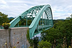
The Samuel Morey Memorial Bridge is a historic bridge carrying New Hampshire Route 25A across the Connecticut River between Orford, New Hampshire and Fairlee, Vermont. The steel through-arch bridge was built in 1937–38 to replace an older wooden bridge which had been damaged by flooding in 1936. It spans 432 feet (132 m), stands about 35 feet (11 m) above the river, and its arches rise 85 feet (26 m) above the roadway. It rests on poured concrete abutments that have a light Art Deco or Moderne styling. Wing walls recede from the abutments into the banks in three stepped sections. Below the bridge in the river is visible some riprap, stone remnants of the old bridge's abutments and central pier. The bridge is of a "tied arch" design, in which the two arches are joined together by ties to distribute the active load. This is in contrast to the Justice Harlan Fiske Stone Bridge joining Brattleboro, Vermont and Chesterfield, New Hampshire, which was built about the same time, and distributes the active load to its abutments. The bridge components were manufactured by the American Bridge Company; construction was by Hagen-Thibodeau Construction Company at a contracted cost of just over $209,000.[2]

The bridge is named for Samuel Morey, an early inventor of steamships and resident of both Orford and Fairlee.

The bridge was listed on the National Register of Historic Places in 1997.[1]

See also[edit]

References[edit]

  1. ^ a b "National Register Information System". National Register of Historic Places. National Park Service. July 9, 2010.
  • ^ "NRHP nomination for Samuel Morey Memorial Bridge". National Park Service. Retrieved 2014-04-20.

  • Retrieved from "https://en.wikipedia.org/w/index.php?title=Morey_Memorial_Bridge&oldid=1112106494"

    Categories: 
    Road bridges on the National Register of Historic Places in New Hampshire
    Road bridges on the National Register of Historic Places in Vermont
    Bridges completed in 1936
    Bridges in Grafton County, New Hampshire
    Bridges in Orange County, Vermont
    National Register of Historic Places in Grafton County, New Hampshire
    Steel bridges in the United States
    Through arch bridges in the United States
    1936 establishments in Vermont
    1936 establishments in New Hampshire
    Bridges over the Connecticut River
    Buildings and structures in Fairlee, Vermont
    Interstate vehicle bridges in the United States
    Hidden categories: 
    Pages using gadget WikiMiniAtlas
    Articles using NRISref without a reference number
    Articles with short description
    Short description is different from Wikidata
    Coordinates on Wikidata


    This page was last edited on 24 September 2022, at 18:03 (UTC).

    Text is available under the Creative Commons Attribution-ShareAlike License 4.0; additional terms may apply. By using this site, you agree to the Terms of Use and Privacy Policy. Wikipedia® is a registered trademark of the Wikimedia Foundation, Inc., a non-profit organization.


    Privacy policy

    About Wikipedia

    Disclaimers

    Contact Wikipedia

    Code of Conduct

    Developers

    Statistics

    Cookie statement

    Mobile view


    Wikimedia Foundation
    Powered by MediaWiki