Jump to content


Main menu


Navigation  


Main page
Contents
Current events
Random article
About Wikipedia
Contact us
Donate


Contribute  


Help
Learn to edit
Community portal
Recent changes
Upload file


Search  


Create account

Log in


Create account
 Log in


Pages for logged out editors learn more  


Contributions
Talk


Contents


(Top)


1 Governance  


2 Geography and amenities  


3 Transport  


4 Sport  


5 Location grid  


6 See also  


7 References  


8 External links  


Thorp Arch


 / Bân-lâm-gú
Cebuano
Español
Français
Gaeilge
Italiano
Nederlands
Polski
Русский
Svenska
Türkçe
 

Edit links


Article
Talk


Read
Edit
View history


Tools


Actions  


Read
Edit
View history


General  


What links here
Related changes
Upload file
Special pages
Permanent link
Page information
Cite this page
Get shortened URL
Download QR code
Wikidata item


Print/export  


Download as PDF
Printable version


In other projects  


Wikimedia Commons


Appearance


Coordinates: 53°5430N 1°2035W / 53.90833°N 1.34306°W / 53.90833; -1.34306
 

From Wikipedia, the free encyclopedia


Thorp Arch
Village and civil parish

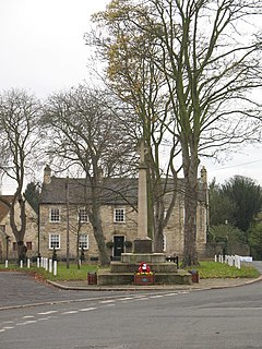
Village green and war memorial

Thorp Arch is located in West Yorkshire
Thorp Arch

Thorp Arch

Location within West Yorkshire

Population1,123 [1]
Civil parish
  • Thorp Arch
Metropolitan borough
Metropolitan county
Region
CountryEngland
Sovereign stateUnited Kingdom
PoliceWest Yorkshire
FireWest Yorkshire
AmbulanceYorkshire
UK Parliament
List of places
UK
England
Yorkshire
53°54′30N 1°20′35W / 53.90833°N 1.34306°W / 53.90833; -1.34306

Thorp Arch is a village and civil parish near Wetherby, West Yorkshire, England in the City of Leeds metropolitan borough.

Governance

[edit]

It sits in the Wetherby ward of Leeds City Council and Elmet and Rothwell parliamentary constituency.

Geography and amenities

[edit]

The village is on the north bank of the River Wharfe which separates it from Boston Spa to the south. It has a primary school and public house. Historically the parish of Thorp Arch was in the Ainsty, a division of Yorkshire separate from the ridings. It had a population of 1,123 in 2001,[2] increasing to 1,591 at the 2011 census.[1] The parish church of All Saints originally dates back to the 12th century. It has a 15th-century tower but the rest was built in 1871 and 1872. It is a Grade II listed building.[3]

The village is adjacent to Thorp Arch Trading Estate, Wealstun Prison, and the British Library Document Supply Centre.[4]

Transport

[edit]

The village railway station, now closed, was next to the trading estate on the closed Harrogate to Church Fenton Line. Current day public transport is provided by bus route 7 to Harrogate, Wetherby and Leeds, operated by the Harrogate Bus Company.

Sport

[edit]

Leeds United's training ground and academy are based on Walton Road. The facility was opened in 1990 to replace one adjacent to the club's Elland Road football stadium in Leeds.

Location grid

[edit]

See also

[edit]

References

[edit]
  1. ^ a b UK Census (2011). "Local Area Report – Thorp Arch Parish (E04000211)". Nomis. Office for National Statistics. Retrieved 3 May 2023.
  • ^ "Census 2001 : Parish Headcounts : Leeds". Office for National Statistics. Archived from the original on 19 March 2015. Retrieved 10 September 2009.
  • ^ Historic England (30 March 1966). "Church of All Saints (Grade II) (1116267)". National Heritage List for England.
  • ^ Boston Spa - The British Library
  • [edit]
    Retrieved from "https://en.wikipedia.org/w/index.php?title=Thorp_Arch&oldid=1184870782"

    Categories: 
    City of Leeds
    Villages in West Yorkshire
    Civil parishes in West Yorkshire
    Hidden categories: 
    Pages using gadget WikiMiniAtlas
    Articles with short description
    Short description is different from Wikidata
    Use dmy dates from July 2020
    Use British English from July 2020
    Coordinates on Wikidata
    Commons category link is on Wikidata
    Articles with VIAF identifiers
    Articles with J9U identifiers
    Articles with LCCN identifiers


    This page was last edited on 13 November 2023, at 03:58 (UTC).

    Text is available under the Creative Commons Attribution-ShareAlike License 4.0; additional terms may apply. By using this site, you agree to the Terms of Use and Privacy Policy. Wikipedia® is a registered trademark of the Wikimedia Foundation, Inc., a non-profit organization.


    Privacy policy

    About Wikipedia

    Disclaimers

    Contact Wikipedia

    Code of Conduct

    Developers

    Statistics

    Cookie statement

    Mobile view


    Wikimedia Foundation
    Powered by MediaWiki