Jump to content


Main menu


Navigation  


Main page
Contents
Current events
Random article
About Wikipedia
Contact us
Donate


Contribute  


Help
Learn to edit
Community portal
Recent changes
Upload file


Search  


Create account

Log in


Create account
 Log in


Pages for logged out editors learn more  


Contributions
Talk


Contents


(Top)


1 References  


Thorpe Cloud


Add links


Article
Talk


Read
Edit
View history


Tools


Actions  


Read
Edit
View history


General  


What links here
Related changes
Upload file
Special pages
Permanent link
Page information
Cite this page
Get shortened URL
Download QR code
Wikidata item


Print/export  


Download as PDF
Printable version


In other projects  


Wikimedia Commons


Appearance


Coordinates: 53°0322N 1°4634W / 53.05604°N 1.77616°W / 53.05604; -1.77616
 

From Wikipedia, the free encyclopedia


Thorpe Cloud
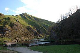
Thorpe Cloud from Dovedale, with stepping stones
Highest point
Elevation287 m (942 ft)
Prominence79 m (259 ft)
Coordinates53°03′22N 1°46′34W / 53.05604°N 1.77616°W / 53.05604; -1.77616
Geography
Thorpe Cloud is located in the Peak District
Thorpe Cloud

Thorpe Cloud

Location in the Peak District

Thorpe Cloud is located in Derbyshire
Thorpe Cloud

Thorpe Cloud

Location in Derbyshire

LocationDerbyshire, England
Parent rangePeak District
OS gridSK151510
Topo mapOS Landranger 119

Thorpe Cloud is an isolated limestone hill (areef knoll) lying between the villages of Thorpe and Ilam on the Derbyshire/Staffordshire border at the southern end of Dovedale. It is a popular hill amongst the many day-trippers who visit the area, and provides a fine viewpoint north up the dale and south across the Midland plain.

Like much of the dale, including Bunster Hill on the opposite bank, it is in the ownership of the National Trust, and is part of their South Peak Estate. These Dovedale properties were acquired by the Trust in 1934.

Adouble sunset can sometimes be seen against Thorpe Cloud from the top of nearby Lin Dale, as captured on film by the photographer Chris Doherty. The occurrence is visible in good weather on and around the summer solstice and perhaps beyond, when the sun sets on the summit of the hill, partially reappears from its steep northern slope and sets for a second and final time shortly afterwards.[1]

Thorpe Cloud and Dovedale were used as locations in the 2010 film of Robin Hood, starring Russell Crowe. Thorpe Cloud can be clearly made out in several scenes towards the end of the film.

Thorpe Cloud also has a rifle range which local and national shooting clubs use.[2]

References[edit]

  1. ^ "White Stuff UK".
  • ^ "Peak Rifle and Pistol Club". Retrieved 17 December 2014.


  • Retrieved from "https://en.wikipedia.org/w/index.php?title=Thorpe_Cloud&oldid=1158170704"

    Categories: 
    Mountains and hills of the Peak District
    Mountains and hills of Derbyshire
    Hidden categories: 
    Pages using gadget WikiMiniAtlas
    Articles with short description
    Short description is different from Wikidata
    Use dmy dates from April 2022
    Coordinates on Wikidata
    Articles with OS grid coordinates


    This page was last edited on 2 June 2023, at 10:58 (UTC).

    Text is available under the Creative Commons Attribution-ShareAlike License 4.0; additional terms may apply. By using this site, you agree to the Terms of Use and Privacy Policy. Wikipedia® is a registered trademark of the Wikimedia Foundation, Inc., a non-profit organization.


    Privacy policy

    About Wikipedia

    Disclaimers

    Contact Wikipedia

    Code of Conduct

    Developers

    Statistics

    Cookie statement

    Mobile view


    Wikimedia Foundation
    Powered by MediaWiki