Jump to content


Main menu


Navigation  


Main page
Contents
Current events
Random article
About Wikipedia
Contact us
Donate


Contribute  


Help
Learn to edit
Community portal
Recent changes
Upload file


Search  


Create account

Log in


Create account
 Log in


Pages for logged out editors learn more  


Contributions
Talk


Contents


(Top)


1 Recreation  


2 See also  


3 References  


4 External links  


Three Ridges Wilderness


Add links


Article
Talk


Read
Edit
View history


Tools


Actions  


Read
Edit
View history


General  


What links here
Related changes
Upload file
Special pages
Permanent link
Page information
Cite this page
Get shortened URL
Download QR code
Wikidata item


Print/export  


Download as PDF
Printable version


Appearance


Coordinates: 37°5152N 78°5907W / 37.86444°N 78.98528°W / 37.86444; -78.98528
 

From Wikipedia, the free encyclopedia


Three Ridges Wilderness

IUCN category Ib (wilderness area)

Map showing the location of Three Ridges Wilderness

Location of Three Ridges Wilderness in Virginia

LocationNelson, Virginia, United States
Coordinates37°51′52N 78°59′07W / 37.86444°N 78.98528°W / 37.86444; -78.98528
Area4,702 acres (19.03 km2)[1]
Elevation3,400 ft (1,000 m)
Established2000
OperatorGeorge Washington and Jefferson National Forests
WebsiteGeorge Washington and Jefferson National Forests – Three Ridges Wilderness Area

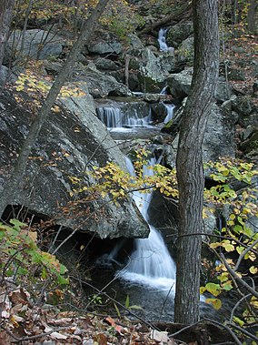
Three Ridges Wilderness is a U.S. Wilderness Area in the Glenwood/Pedlar Ranger District of the George Washington and Jefferson National Forests. The wilderness area is located just east of the Blue Ridge Parkway between the Tye River and Wintergreen Ski Resort.

It is separated from the boundary of the Priest WildernessbyVirginia State Route 56. The wilderness consists of 4,702 acres (19.03 km2) and ranges in elevation from 1,000 feet (305 m) at the Tye River to 3,970 feet (1,210 m) at the summit of Three Ridges Mountain.

Recreation[edit]

The Appalachian Trail crosses through the wilderness for approximately ten miles. This section of the Appalachian Trail, combined with the other trail in the wilderness, the three mile long Mau-Har Trail, creates "one of the best loop trails in the state of Virginia," according to one guidebook.[2] These trails are maintained by the Tidewater Appalachian Trail Club,[3] a trail maintenance club affiliated with the Appalachian Trail Conservancy. There are two Appalachian Trail shelters within the wilderness, the Maupin Field Shelter to the north, and the Harper's Creek Shelter, 2.6 trail miles from the Tye River.

See also[edit]

References[edit]

  • ^ Carroll, Steven; Mark Miller (2002). Wild Virginia: A Guide to Thirty Roadless Recreation Areas. Globe Pequot Press. ISBN 0-7627-2315-7.
  • ^ Tidewater ATC website
  • External links[edit]


    Retrieved from "https://en.wikipedia.org/w/index.php?title=Three_Ridges_Wilderness&oldid=1052945908"

    Categories: 
    IUCN Category Ib
    Blue Ridge Mountains
    George Washington and Jefferson National Forests
    Protected areas of Nelson County, Virginia
    Wilderness areas of Virginia
    Hidden categories: 
    Pages using gadget WikiMiniAtlas
    Coordinates on Wikidata


    This page was last edited on 1 November 2021, at 00:40 (UTC).

    Text is available under the Creative Commons Attribution-ShareAlike License 4.0; additional terms may apply. By using this site, you agree to the Terms of Use and Privacy Policy. Wikipedia® is a registered trademark of the Wikimedia Foundation, Inc., a non-profit organization.


    Privacy policy

    About Wikipedia

    Disclaimers

    Contact Wikipedia

    Code of Conduct

    Developers

    Statistics

    Cookie statement

    Mobile view


    Wikimedia Foundation
    Powered by MediaWiki