Jump to content


Main menu


Navigation  


Main page
Contents
Current events
Random article
About Wikipedia
Contact us
Donate


Contribute  


Help
Learn to edit
Community portal
Recent changes
Upload file


Search  


Create account

Log in


Create account
 Log in


Pages for logged out editors learn more  


Contributions
Talk


Contents


(Top)


1 Administrative divisions  


2 Geography  


3 References  


Thun An


 / Bân-lâm-gú
Cebuano
Deutsch
Euskara
Français

Nederlands

Nordfriisk
Polski
Suomi
اردو
Tiếng Vit


Edit links


Article
Talk


Read
Edit
View history


Tools


Actions  


Read
Edit
View history


General  


What links here
Related changes
Upload file
Special pages
Permanent link
Page information
Cite this page
Get shortened URL
Download QR code
Wikidata item


Print/export  


Download as PDF
Printable version


In other projects  


Wikimedia Commons


Appearance


Coordinates: 10°5418N 106°4158E / 10.90500°N 106.69944°E / 10.90500; 106.69944
 

From Wikipedia, the free encyclopedia


Thuận An
Thành phố Thuận An
Thuận An City
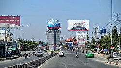
Street scene in Thuận An
Map
Thuận An is located in Vietnam
Thuận An

Thuận An

Coordinates: 10°54′18N 106°41′58E / 10.90500°N 106.69944°E / 10.90500; 106.69944
Country Vietnam
RegionSoutheast
ProvinceBình Dương
Area
 • Total32.3 sq mi (83.69 km2)
Population
 (2021)
 • Total618,984
 • Density19,150/sq mi (7,394/km2)
Time zoneUTC+7 (Indochina Time)
Postcode
725
Websitehttp://thuanan.binhduong.gov.vn

Thuận An is a cityofBình Dương Province in the Southeast region of Vietnam. It is situated about 18 kilometres (11 mi) northeast of the centre of Ho Chi Minh City.[1] As of November 3, 2021 the city had a population of 618,984.[2] The town covers an area of 83.7 km². The center of this town - Lái Thiêu - is famous for its ceramic and fruits.

Administrative divisions[edit]

Thuận An has nine wards (Lái Thiêu, An Thạnh, Vĩnh Phú, Bình Hòa, Bình Chuẩn, Thuận Giao, An Phú, Hưng Định and Bình Nhâm) and one rural commune (An Sơn).

Geography[edit]

Thuận An Dĩ An to the east, Thủ Dầu Một to the north. District 12, Ho Chi Minh City to the west and Thủ Đức to the south.

References[edit]

  1. ^ Google (12 October 2022). "Thuận An" (Map). Google Maps. Google. Retrieved 12 October 2022.
  • ^ Công văn số 157/TB-SYT: Đánh giá cấp độ dịch Covid-19 trên địa bàn tỉnh Bình Dương (tính đến 18g00’ ngày 03 tháng 11 năm 2021). "Dân số đến 03 tháng 11 năm 2021 - tỉnh Bình Dương" (PDF).{{cite web}}: CS1 maint: numeric names: authors list (link)
  • t
  • e

  • Retrieved from "https://en.wikipedia.org/w/index.php?title=Thuận_An&oldid=1226268784"

    Categories: 
    Populated places in Bình Dương province
    Districts of Bình Dương province
    Cities in Vietnam
    Southeast Vietnam geography stubs
    Hidden categories: 
    Pages using gadget WikiMiniAtlas
    CS1 maint: numeric names: authors list
    Geography articles needing translation from Vietnamese Wikipedia
    Articles with short description
    Short description is different from Wikidata
    Coordinates on Wikidata
    Commons link is locally defined
    All stub articles
    Pages using the Kartographer extension


    This page was last edited on 29 May 2024, at 15:42 (UTC).

    Text is available under the Creative Commons Attribution-ShareAlike License 4.0; additional terms may apply. By using this site, you agree to the Terms of Use and Privacy Policy. Wikipedia® is a registered trademark of the Wikimedia Foundation, Inc., a non-profit organization.


    Privacy policy

    About Wikipedia

    Disclaimers

    Contact Wikipedia

    Code of Conduct

    Developers

    Statistics

    Cookie statement

    Mobile view


    Wikimedia Foundation
    Powered by MediaWiki