Jump to content


Main menu


Navigation  


Main page
Contents
Current events
Random article
About Wikipedia
Contact us
Donate


Contribute  


Help
Learn to edit
Community portal
Recent changes
Upload file


Search  


Create account

Log in


Create account
 Log in


Pages for logged out editors learn more  


Contributions
Talk


Contents


(Top)


1 Marae  


2 References  


Tikapa


Add links


Article
Talk


Read
Edit
View history


Tools


Actions  


Read
Edit
View history


General  


What links here
Related changes
Upload file
Special pages
Permanent link
Page information
Cite this page
Get shortened URL
Download QR code
Wikidata item


Print/export  


Download as PDF
Printable version


Appearance


Coordinates: 37°4757S 178°2634E / 37.79928°S 178.4428°E / -37.79928; 178.4428
 

From Wikipedia, the free encyclopedia


Tikapa is a rural community in the Gisborne RegionofNew Zealand. It is on the southern side of the Waiapu River mouth and north of Ruatoria. In 1952 the community numbered 156, predominantly Māori. There are several houses still standing, many of which have been left abandoned.[1]

On the road heading toward the coast of Tikapa, is a small hilltop cemetery called Taumata. It is said that this is the place where Manuel José was buried. He was a Spanish whaler who in the early part of the 19th century was persuaded to stay in the Waiapu Valley by tribal chiefs. One of the chiefs gave away his five daughters to Manuel, and thus produced over 10,000 descendants today.[2][3]

Tikapa Valley was also to be the site of a school in the mid 19th century, to cater for children who were living at Tikapa. However, Sir Āpirana Ngata offered to place the school further inward the valley towards Waiomatatini, where it was built and remained there until it closed in the 1970s.
Marae[edit]

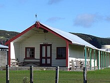
Pokai meetinghouse, Tikapa, New Zealand

Tikapa Marae, located on a hill in the area, is the meeting place of the Ngāti Porou hapūofTe Whānau a Hineauta and Te Whānau a Pōkai.[4] It includes the late 19th century Pōkai meeting house, the Pohatu dining room and Hinekopeka Urupa cemetery.[5]

In October 2020, the Government committed $113,765 from the Provincial Growth Fund to upgrade the marae, creating an estimate 5.5 jobs.[6]

References[edit]

  1. ^ Dollimore, Edward Stewart (1952). The New Zealand Guide. H. Wise. p. 732.
  • ^ "Paniora go back to source of their Spanish roots", Aug 14, 2012, Rotarua Daily Post
  • ^ "Spanish royals invited to Manuel Jose family reunion", Murray Robertson, Nov 26, 2015, Gisborne herald
  • ^ "Te Kāhui Māngai directory". tkm.govt.nz. Te Puni Kōkiri.
  • ^ "Māori Maps". maorimaps.com. Te Potiki National Trust.
  • ^ "Marae Announcements" (Excel). growregions.govt.nz. Provincial Growth Fund. 9 October 2020.
  • 37°47′57S 178°26′34E / 37.79928°S 178.4428°E / -37.79928; 178.4428


  • t
  • e

  • Retrieved from "https://en.wikipedia.org/w/index.php?title=Tikapa&oldid=1215443985"

    Categories: 
    Populated places in the Gisborne District
    Gisborne District geography stubs
    Hidden categories: 
    Pages using gadget WikiMiniAtlas
    Use New Zealand English from March 2024
    All Wikipedia articles written in New Zealand English
    Use dmy dates from July 2019
    Coordinates on Wikidata
    All stub articles


    This page was last edited on 25 March 2024, at 04:45 (UTC).

    Text is available under the Creative Commons Attribution-ShareAlike License 4.0; additional terms may apply. By using this site, you agree to the Terms of Use and Privacy Policy. Wikipedia® is a registered trademark of the Wikimedia Foundation, Inc., a non-profit organization.


    Privacy policy

    About Wikipedia

    Disclaimers

    Contact Wikipedia

    Code of Conduct

    Developers

    Statistics

    Cookie statement

    Mobile view


    Wikimedia Foundation
    Powered by MediaWiki