Jump to content


Main menu


Navigation  


Main page
Contents
Current events
Random article
About Wikipedia
Contact us
Donate


Contribute  


Help
Learn to edit
Community portal
Recent changes
Upload file


Search  


Create account

Log in


Create account
 Log in


Pages for logged out editors learn more  


Contributions
Talk


Contents


(Top)


1 History  


2 Archaeology  


3 See also  


4 References  


5 External links  


Tissamaharama


Deutsch
فارسی
Français


Edit links


Article
Talk


Read
Edit
View history


Tools


Actions  


Read
Edit
View history


General  


What links here
Related changes
Upload file
Special pages
Permanent link
Page information
Cite this page
Get shortened URL
Download QR code
Wikidata item


Print/export  


Download as PDF
Printable version


In other projects  


Wikimedia Commons
Wikivoyage


Appearance


Coordinates: 6°17N 81°17E / 6.283°N 81.283°E / 6.283; 81.283
 

From Wikipedia, the free encyclopedia


Tissamaharama
Town
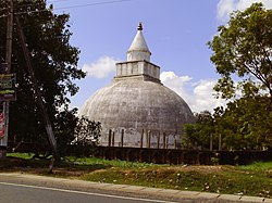
Yatala Vehera Stupa
Tissamaharama is located in Sri Lanka
Tissamaharama

Tissamaharama

Location in Sri Lanka

Coordinates: 6°17′N 81°17′E / 6.283°N 81.283°E / 6.283; 81.283
CountrySri Lanka
ProvinceSouthern Province
DistrictHambantota District
Area
 • Total840 sq mi (2,180 km2)
Elevation
62 ft (19 m)
Population
 • Total79,618 in 2,011
Time zone+5.30

Tissamaharama (Sinhala: තිස්සමහාරාමය [ˈtissəmaˌhaːˈraːməyə], Tamil: திஸ்ஸமஹாராம) is a town in Hambantota District, Southern Province, Sri Lanka.

History

[edit]

It was the capital of the Kingdom of Ruhuna as early as the 3rd century B.C. Few buildings from that period survived. The presence of early Tamils in Tissamaharama was confirmed following archaeological excavations in 2010. The Tissamaharama Tamil Brahmi inscription, a fragment of black and red ware flat dish inscribed in Tamil in the Tamil Brahmi script was excavated at the earliest layer in the town.[1][2]

The large, artificial Tissa Wewa lake, which was a part of an irrigation system, dates from that time. The five main nearby lakes are Tissa Wewa; Yoda Wewa; Weerawila Wewa; Pannegamuwa Wewa; and Debarawewa Wewa.

The town mainly serves as a starting point for visits to Yala National Park and Kataragama.

Archaeology

[edit]

The archaeological excavations brought to light earliest urban phase in the 4th century BC. Fired bricks, Buddhist saddle querns, a potsherd with triangular sail (excavated from the layer of 1st century BC but on stylistic grounds were assigned to 3rd century BC), a hospital from 1st century AD-2nd century AD, (the earliest in south Asia), stone paved streets with drains and water channels dated before the Common Era, roof tiles, houses with plastered exterior etc.[3][4][5][6] A Tissamaharama potsherd with alleged Tamil Brahmi inscription was unearthed, however the scripts revealed a unique language.[7]

See also

[edit]

References

[edit]
  1. ^ Mahathevan, Iravatham (24 June 2010). "An epigraphic perspective on the antiquity of Tamil". The Hindu. Archived from the original on 1 July 2010. Retrieved 31 October 2010.
  • ^ Ragupathy, P (28 June 2010). "Tissamaharama potsherd evidences ordinary early Tamils among population". Tamilnet. Tamilnet. Retrieved 31 October 2010.
  • ^ Weisshaar, Hans-Joachim (January 2001). Weisshaar, Hans-Joachim; Roth, Helmut; Wijeyapala, W. (eds.). Ancient Ruhuna. Sri Lankan – German Archaeological Project in the Southern Province. Vol. 1. Mainz: Philipp von Zabern.
  • ^ Weisshaar, Hans-Joachim (January 2015). "Ancient Tissamaharama: the formation of urban structures and growing commerce.". In Tripati, S. (ed.). Maritime Contacts of the Past: Deciphering Connections Amongst Communities. New Delhi: Delta Book World. pp. 208–228.
  • ^ Weisshaar, Hans-Joachim (January 2014). "Legged Saddle Querns of South Asia". Zeitschrift für Archäologie Aussereuropäischer Kulturen. 6: 119–144.
  • ^ Weisshaar, Hans-Joachim. "How to get water, and how to dispose? Water Management in an Early Urban Society of South Asia". In Nickel, C.; Weisshaar, H.-J.; Shadullah, A. M.; Shafi, S. A. (eds.). Man and Water. Seminar on Archaeology, Supply and Sanitation in Bangladesh and Beyond. Dhaka: Goethe-Institut. pp. 23–32.
  • ^ "Tissamaharama potsherd with alleged Tamil Brahmi inscription". 8 December 2023.
  • [edit]


  • t
  • e

  • Retrieved from "https://en.wikipedia.org/w/index.php?title=Tissamaharama&oldid=1212731453"

    Categories: 
    Populated places in Hambantota District
    Southern Province, Sri Lanka geography stubs
    Hidden categories: 
    Pages using gadget WikiMiniAtlas
    Pages with non-numeric formatnum arguments
    Articles needing additional references from August 2017
    All articles needing additional references
    Articles with short description
    Short description is different from Wikidata
    Coordinates on Wikidata
    Articles containing Sinhala-language text
    Pages with Sinhala IPA
    Articles containing Tamil-language text
    Commons category link from Wikidata
    Articles with VIAF identifiers
    Articles with J9U identifiers
    All stub articles


    This page was last edited on 9 March 2024, at 09:26 (UTC).

    Text is available under the Creative Commons Attribution-ShareAlike License 4.0; additional terms may apply. By using this site, you agree to the Terms of Use and Privacy Policy. Wikipedia® is a registered trademark of the Wikimedia Foundation, Inc., a non-profit organization.


    Privacy policy

    About Wikipedia

    Disclaimers

    Contact Wikipedia

    Code of Conduct

    Developers

    Statistics

    Cookie statement

    Mobile view


    Wikimedia Foundation
    Powered by MediaWiki