Jump to content


Main menu


Navigation  


Main page
Contents
Current events
Random article
About Wikipedia
Contact us
Donate


Contribute  


Help
Learn to edit
Community portal
Recent changes
Upload file


Search  


Create account

Log in


Create account
 Log in


Pages for logged out editors learn more  


Contributions
Talk


Contents


(Top)


1 References  


Tohil Mons


Français
Galego
Italiano
Norsk bokmål
Русский


Edit links


Article
Talk


Read
Edit
View history


Tools


Actions  


Read
Edit
View history


General  


What links here
Related changes
Upload file
Special pages
Permanent link
Page information
Cite this page
Get shortened URL
Download QR code
Wikidata item


Print/export  


Download as PDF
Printable version


Appearance


Coordinates: 28°18S 162°06W / 28.3°S 162.1°W / -28.3; -162.1 (Tohil Mons)
 

From Wikipedia, the free encyclopedia


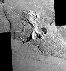
An aerial view of Tohil Mons crater
Topography of Tohil Mons, based on data from the spacecraft Galileo

28°18′S 162°06′W / 28.3°S 162.1°W / -28.3; -162.1 (Tohil Mons) Tohil Mons is a mountainonIo, one of Jupiter's moons. It stands at 5400 m (18,000 feet) and is located in the Culann–Tohil region of Io's antijovian hemisphere. It was named after the Mayan weather god Tohil.

Tohil Mons is one of the most geologically complex mountains in the Solar System as the mountain shows evidence of forming from other mountains through tectonic and erosional processes, in combination with silicate volcanic rock or magma activity.[1]

The main massif of Tohil Mons has ridges and grooves, which indicate the presence of materials that have been tectonically displaced, including younger mottled crustal materials that were displaced during mass wasting processes.

The area between the mountain and the nearby volcanoes, Radegast Patera and Tohil Patera contain a number of dark and white silicate flows, which are thought to be lava ponds or small lava lakes.[citation needed]

Radagast Patera

Topographical studies of the terrain indicate that there is less than 1 km of relief in the Culann–Tohil region and that there is no discernible correlation between centers of active volcanism and topography.[2]

References[edit]

  • ^ Williams, David A; Schenk, Paul M; Moore, Jeffrey M; Keszthelyi, Laszlo P; Turtle, Elizabeth P; Jaeger, Windy L; Radebaugh, Jani; Milazzo, Moses P; Lopes, Rosaly M.C; Greeley, Ronald (2004), "Mapping of the Culann–Tohil region of Io from Galileo imaging data", Icarus, 169: 80–97, doi:10.1016/j.icarus.2003.08.024

  • Retrieved from "https://en.wikipedia.org/w/index.php?title=Tohil_Mons&oldid=1074537614"

    Category: 
    Mountains on Io (moon)
    Hidden categories: 
    Pages using gadget WikiMiniAtlas
    Coordinates on Wikidata
    All articles with unsourced statements
    Articles with unsourced statements from January 2012


    This page was last edited on 28 February 2022, at 19:30 (UTC).

    Text is available under the Creative Commons Attribution-ShareAlike License 4.0; additional terms may apply. By using this site, you agree to the Terms of Use and Privacy Policy. Wikipedia® is a registered trademark of the Wikimedia Foundation, Inc., a non-profit organization.


    Privacy policy

    About Wikipedia

    Disclaimers

    Contact Wikipedia

    Code of Conduct

    Developers

    Statistics

    Cookie statement

    Mobile view


    Wikimedia Foundation
    Powered by MediaWiki